
The geography of Mozambique consists mostly of coastal lowlands with uplands in its center and high plateaus in the northwest. There are also mountains in the western portion. The country is located on the east coast of southern Africa, directly west of the island of Madagascar. Mozambique has a tropical climate with two seasons, a wet season from October to March and a dry season from April to September.

Portuguese Mozambique or Portuguese East Africa were the common terms by which Mozambique was designated during the period in which it was a Portuguese overseas province. Portuguese Mozambique originally constituted a string of Portuguese possessions along the south-east African coast, and later became a unified province, which now forms the Republic of Mozambique.

The Mfecane, also known by the Sesotho names Difaqane or Lifaqane, was a historical period of heightened military conflict and migration associated with state formation and expansion in Southern Africa. The exact range of dates that comprise the Mfecane varies between sources. At its broadest, the period lasted from the late eighteenth century to the mid-nineteenth century, but scholars often focus on an intensive period from the 1810s to the 1840s.

Sofala is a province of Mozambique. It has a population of 2,259,248. Beira is the capital of the province, named for the ruined port of Sofala which is 35 kilometres (22 mi) to the south.

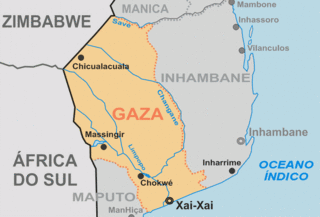
Gaza is a province of Mozambique. It has an area of 75,709 km2 and a population of 1,422,460, which is the least populous of all the provinces of Mozambique.
The Ndau are an ethnic group. The name "Ndau" means Land. Just like the Manyika people in northern Manicaland, their name Manyika also meaning "Owners of the Land", the name Ndau means Land. E.g "Ndau yedu" meaning "our land" When the Ngoni observed this, they called them the Ndau people, the name itself meaning the land, the place or the country in their language. A traditional outsider suggestion is that the name is derived from the Nguni words "Amading'indawo" which means "those looking for a place" as this is what the Gaza Nguni called them and the name then evolved to Ndau. However, they are described in detail to have already been occupying parts of Zimbabwe and Mozambique in 1500s by the Portuguese missionary Joao dos Santos. The five largest Ndau groups are the Magova; the Mashanga; the Vatomboti, the Madanda and the Teve. Ancient Ndau People met with the Khoi/San during the first trade with the Arabs at Mapungumbwe and its attributed to the Kalanga, Venda, Shona, and Ndau peoples. They traded with Arabs with "Mpalu", "Njeti" and "Vukotlo" these are the red, white and blue coloured cloths together with golden beads. Ndau people traded traditional herbs, spiritual powers, animal skins and bones.

Ngungunyane, also known as Mdungazwe Ngungunyane Nxumalo, N'gungunhana, or Gungunhana Reinaldo Frederico Gungunhana, was a king of the Gaza Empire and vassal of the Portuguese Empire, who rebelled, was defeated by General Joaquim Mouzinho de Albuquerque and lived out the rest of his life in exile, first in Lisbon, but later on the island of Terceira, in the Azores.
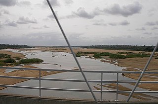
The Save River, or Sabi River is a 640 km (400 mi) river of southeastern Africa, flowing through Zimbabwe and Mozambique. The river has its source in Zimbabwe, some 80 km (50 mi) south of Harare, then flows south and then east, from the Zimbabwean highveld to its confluence with the Odzi River. It then turns south, drops over the Chivirira Falls, and flows down the western side of Zimbabwe's Eastern Highlands, forming a dry river valley in the rain shadow of these mountains. It is joined by the Runde River or Lundi at the Mozambique border, forming a dramatic confluence at Mahenya. It then crosses Mozambique to flow into the Indian Ocean at about 21°S.

Cashel is a village in Chimanimani District of Manicaland Province, Zimbabwe. It is located near the Mozambique border, just north of the Chimanimani Mountains. Forestry, bananas, wheat, and various cash crops are grown in the area. It was originally called Penkridge but was changed to Cashel in 1957. It was named after Lt. Col. E. Cashel, a former member of the British South Africa Police and the Rhodesian Volunteers, who retired to this area after World War I. The Cashel valley is well known for radio and television commercials, which sought to extol the quality of its peas, beans and other agricultural products.
Soshangana Ka Gasa Zikode, born Soshangana Nxumalo, was the Founder and the Monarch of the Gaza Empire, which at the height of its power stretched from the Limpopo river in southern Mozambique up to the Zambezi river in the north. Soshangana ruled over the Gaza state from 1825 until his death in 1858. Soshangana was also known by the name of Manukosi.
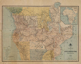
The Pink Map, also known as the Rose-Coloured Map, was a map prepared in 1885 to represent the Kingdom of Portugal's claim of sovereignty over a land corridor connecting the Portuguese colonies of Angola and Mozambique during the Scramble for Africa. The area claimed included most of modern-day Zimbabwe and large parts of modern-day Zambia and Malawi.
Articles related to Mozambique include:
The Chopi are a Bantu ethnic group of Mozambique. They have lived primarily in the Zavala region of southern Mozambique, in the Inhambane Province. They traditionally lived a life of subsistence agriculture, traditionally living a rural existence, although many were displaced or killed in the civil war that followed Mozambique's liberation from Portuguese colonial rule in 1975. In addition, drought forced many away from their homeland and into the nation's cities.
The Gaza Empire (1824–1895) was an African empire established by general Soshangane and was located in southeastern Africa in the area of southern Mozambique and southeastern Zimbabwe. The Gaza Empire, at its height in the 1860s, covered all of Mozambique between the Zambezi and Limpopo rivers, known as Gazaland.

The wildlife of Mozambique consists of the flora and fauna of this country in southeastern Africa. Mozambique has a range of different habitat types and an ecologically rich and diverse wildlife. This includes 236 species of mammal, 740 species of bird and 5,692 species of vascular plant. The Maputaland-Pondoland-Albany hotspot, with significantly high levels of biodiversity, stretches from the southern tip of Mozambique into northeastern South Africa.
King Mzila Nxumalo, Mzila kaSoshangane Nxumalo, Umzila, Muzila, or Nyamende was the son of Soshangane kaZikode, the founder of the Gaza empire, which at the height of its power stretched from southern Mozambique to the Limpopo River. He defeated his brother Mawewe kaSoshangane in 1861 to ascend to the Gaza throne which he ruled from 1861 to 1885. He was father of King Ngungunyane Nxumalo Gungunhana|Ndungazwe who was deposed by the Portuguese invasion Portuguese Empire.
St Vincent Whitshed Erskine, Surveyor General of South Africa, was an early explorer in Gazaland and was the first European to travel down the length of the Limpopo river to its mouth.
The Bight of Sofala/Swamp Coast is a marine ecoregion along the eastern coast of Africa, characterized by extensive mangrove swamps and coastal wetlands. It extends along the coast of Mozambique, from Angoche to the Bazaruto Archipelago. It adjoins the East African coral coast ecoregion to the north, and the Delagoa ecoregion to the south.
The Urema Valley, also known as the Urema Graben, is a lowland valley in Sofala Province of central Mozambique.

