| Gdyel | |
|---|---|
| Commune and town | |
 | |
 Gdyel | |
| Coordinates: 35°46′56″N0°25′25″W / 35.782171°N 0.423746°W | |
| Country | |
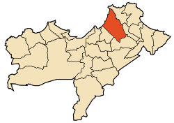
| Province | Oran Province |
| District | Gdyel District |
| Area | |
| • Total | 36.22 sq mi (93.82 km2) |
| Population (2009) | |
| • Total | 39,129 |
| Time zone | UTC+1 (CET) |
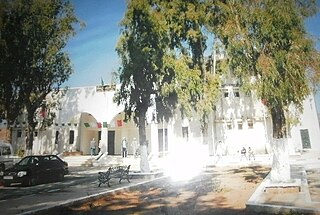
Gdyel (Arabic : قديل), former Saint-Cloud, is a town and commune in District Gdyel, Oran Province, Algeria, about 15 miles to the east of Oran. Under French rule, it was the centre of a wine-growing district and was called St. Cloud.

The municipalities of Algeria form the second level of administrative subdivisions of Algeria. As of 2002, there were 1,541 municipalities in the country.

Oran is a province (wilaya) in Algeria whose seat is the city of the same name.

Algeria, officially the People's Democratic Republic of Algeria, is a country in the Maghreb region of North Africa. The capital and most populous city is Algiers, located in the far north of the country on the Mediterranean coast. With an area of 2,381,741 square kilometres (919,595 sq mi), Algeria is the tenth-largest country in the world, the world's largest Arab country, and the largest in Africa. Algeria is bordered to the northeast by Tunisia, to the east by Libya, to the west by Morocco, to the southwest by the Western Saharan territory, Mauritania, and Mali, to the southeast by Niger, and to the north by the Mediterranean Sea. The country is a semi-presidential republic consisting of 48 provinces and 1,541 communes (counties). It has the highest human development index of all non-island African countries.
According to the 1998 census it has a population of 29 999. [1]
When the Americans invaded Algeria in November 1942 (Operation Torch), the troops who landed at Beach Z, between Arzew and St. Leu (now called Bethioua) were held up for two days by fierce fighting at St. Cloud. Eventually, the town was simply by-passed by Major-General Terry de La Mesa Allen, which surprised the defenders of Oran, who quickly surrendered. [2]

Arzew or Arzeu is a port city in Algeria, 25 miles from Oran. It is the capital of Arzew District, Oran Province.

Bethioua is a town in the wilaya of Oran in the west of Algeria. It has a gas port, petrochemical facilities and desalination plant.