Geerdijk | |
|---|---|
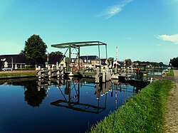 Drawbridge at Geerdijk | |
 Geerdijk Location in the Netherlands  Geerdijk Geerdijk (Netherlands) | |
| Coordinates: 52°28′32″N6°34′11″E / 52.4756°N 6.5698°E | |
| Country | Netherlands |
| Province | Overijssel |
| Municipality | Twenterand |
| Area | |
• Total | 4.52 km2 (1.75 sq mi) |
| Elevation | 10 m (33 ft) |
| Population (2021) [1] | |
• Total | 995 |
| • Density | 220/km2 (570/sq mi) |
| Time zone | UTC+1 (CET) |
| • Summer (DST) | UTC+2 (CEST) |
| Postal code | 7681 & 7686 [1] |
| Dialing code | 0546 |
Geerdijk is a village in the Dutch province of Overijssel. It is located in the municipality of Twenterand. It became a village in 2009.