
Glacier County is located in the U.S. state of Montana. As of the 2020 census, the population was 13,778. The county is located in northwestern Montana between the Great Plains and the Rocky Mountains, known to the Blackfeet as the "Backbone of the World". The county is geographically and culturally diverse and includes the Blackfeet Indian Reservation, Glacier National Park, and Lewis and Clark National Forest. The county is bordered by 75 miles of international boundary with two ports of entry open year-round and one seasonal international border crossing into Alberta, Canada.

Flathead County is a county located in the U.S. state of Montana. At the 2020 census, its population was 104,357, making it the state's fourth most populous county. Its county seat is Kalispell. Its numerical designation is 7. Its northern border is on the state's north border, making it contiguous with the Canada–US border, facing British Columbia.
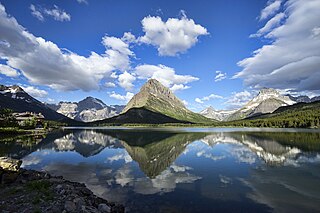
Swiftcurrent Lake is located in the Many Glacier region of Glacier National Park, in the U.S. state of Montana. The Many Glacier Hotel, the largest hotel in the park, is along the east shore of the lake. Many hiking trails originate from the area and scenic tour boats provide access to the lake for visitors.

Grinnell Glacier is in the heart of Glacier National Park in the U.S. state of Montana. The glacier is named for George Bird Grinnell, an early American conservationist and explorer, who was also a strong advocate of ensuring the creation of Glacier National Park. The glacier is in the Lewis Range and rests on the north flank of Mount Gould at an altitude averaging 7,000 feet (2,100 m), in the Many Glacier region of the park.
Glenns Lake is located in Glacier National Park, in the U. S. state of Montana. Glenns Lake is a long narrow lake located between Cosley Ridge and Whitecrow Mountain in the northeastern region of Glacier National Park. Mokowanis Lake is .50 miles (0.80 km) south of Glenns Lake.

Lake Frances is located in Glacier National Park, in the U. S. state of Montana. Runoff from the Dixon Glacier empties into the south side of the lake while runoff from Thunderbird Glacier flows into Thunderbird Creek and into the east shore of the lake.

Lake Wurdeman is located in Glacier National Park, in the U. S. state of Montana. The lake is northwest of Chapman Peak and .50 miles (0.80 km) east of Lake Nooney.
Lake Nooney is located in Glacier National Park, in the U. S. state of Montana. The lake is east of Mount Custer and .50 miles (0.80 km) west of Lake Wurdeman. The Herbst Glacier is located above the lake to the northwest. Rock flour (silt) from melting glaciers make the lake appear opaque turquoise in color.
Falling Leaf Lake is located in Glacier National Park, in the U. S. state of Montana. The lake is in a cirque to the north of Allen Mountain and adjacent to Snow Moon Lake.
Snow Moon Lake is located in Glacier National Park, in the U. S. state of Montana. The lake is in a cirque to the north of Allen Mountain and adjacent to Falling Leaf Lake.
Lake Isabel is located in Glacier National Park, in the U. S. state of Montana. Lake Isabel is northeast of Battlement Mountain and northwest of Vigil Peak. Located in a remote region of Glacier National Park, Lake Isabel is a 30 miles (48 km) roundtrip hike from Two Medicine Lake.

Buffalo Woman Lake is located in Glacier National Park, in the U. S. state of Montana. Buffalo Woman Lake is east of Eaglehead Mountain and .60 miles (0.97 km) south of Beaver Woman Lake.

Lake Ellen Wilson is located in Glacier National Park, in the U. S. state of Montana. Lake Ellen Wilson is .25 miles (0.40 km) upstream from Lincoln Lake but is more than 1,300 feet (400 m) higher in elevation. A series of cascades including Beaver Chief Falls can be found between the two lakes.
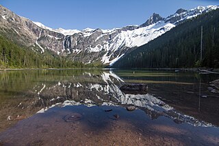
Avalanche Lake is located in Glacier National Park, in the U. S. state of Montana. Avalanche Lake is southwest of Bearhat Mountain and receives meltwater from Sperry Glacier. Avalanche Lake is a 2 miles (3.2 km) hike from the trailhead along the Trail of the Cedars. When measured in August 1910, the maximum depth of the lake was 63 feet (19 m) near the upper end.
Upper Snyder Lake is located in Glacier National Park, in the U. S. state of Montana. Upper Snyder Lake is NNE of Snyder Lake.

Snyder Lake is located in Glacier National Park, in the U. S. state of Montana. Snyder Lake is south-southwest of Upper Snyder Lake.
Akaiyan Lake is located in Glacier National Park, in the U. S. state of Montana. The lake is often ice-clogged and is .75 miles (1.21 km) WSW of Sperry Glacier.
Feather Woman Lake is located in Glacier National Park, in the U. S. state of Montana. The lake is often ice clogged and is 1 mile (1.6 km) WSW of Sperry Glacier.

Logging Lake is located in Glacier National Park, in the U. S. state of Montana. Logging Lake is one of the longest lakes in Glacier National Park at 6 miles (10 km) in length. The Lower Logging Lake Snowshoe Cabin and Boathouse are two structures located near the southwestern end of Logging Lake, and are on the National Register of Historic Places. Logging Lake is a 4.5 miles (7.2 km) hike from the Logging Lake Ranger Station.

The Regional designations of Montana vary widely within the U.S state of Montana. The state is a large geographical area that is split by the Continental Divide, resulting in watersheds draining into the Pacific Ocean, Gulf of Mexico and Hudson's Bay. The state is approximately 545 miles (877 km) east to west along the Canada–United States border and 320 miles (510 km) north to south. The fourth largest state in land area, it has been divided up in official and unofficial ways into a variety of regions. Additionally, Montana is part of a number of larger federal government administrative regions.

