
Mount Bryce is a mountain at the southwestern corner of the Columbia Icefield, in British Columbia, Canada, near the border with Alberta. It can be seen from the Icefields Parkway.

Mount Brazeau is a mountain in Alberta, Canada.

The Blue Range is a mountain range of the Canadian Rockies, located on the Continental Divide in Banff National Park, Canada. The range was so named on account of its blueish colour when viewed from afar. Mount Alcantara is the highest point in the range.

Pyramid Mountain is a mountain in Jasper National Park, Alberta, Canada, named for its pyramid-like shape. James Hector named the mountain in 1859 due to its appearance from the Athabasca River valley on the eastern side of the peak.

Monarch Mountain is one of the principal summits of the Pacific Ranges subdivision of the Coast Mountains in southern British Columbia. It stands just east of a pass between the Klinaklini River and the south branch of the Atnarko River, which is a tributary of the Bella Coola River. Surrounding Monarch Mountain is the Monarch Icefield, the northernmost of the major icefields of the Pacific Ranges, and just south of it is the Ha-Iltzuk Icefield, which is the largest. Monarch is in the southern end of Tweedsmuir South Provincial Park.

Saint Nicholas Peak is a 2,938-metre (9,639-foot) mountain summit in the Rocky Mountains of Canada. It is located on the Continental Divide, on the Alberta-British Columbia border, in both Banff National Park and Yoho National Park. It lies at the eastern edge of the Wapta Icefield, and is part of the Waputik Mountains which are a sub-range of the Canadian Rockies.

Mount Rae is a mountain located on the eastern side of Highway 40 between Elbow Pass and the Ptarmigan Cirque in the Canadian Rockies of Alberta. Mount Rae was named after John Rae, explorer of Northern Canada, in 1859.
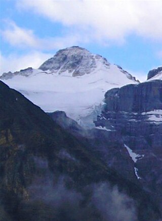
Mount Rutherford is a mountain in Jasper National Park in Alberta, Canada. It is part of the Northern Front Ranges of the Canadian Rockies. Its peak stands 3 km (2 mi) east of Harvey Lake and north of the Snaring River, a tributary of the Athabasca River.

Mount Ratz is a mountain located just west of the Stikine River, about 5 km (3 mi) east of the British Columbia-Alaska border. It is the highest peak in the Stikine Icecap and of the Boundary Ranges which in turn form part of the Coast Mountains. It is an extremely high-prominence summit, with a difference in elevation with its "key col" at Hyland Ranch Pass of 2,430 m (7,972 ft). Thus making it one of Canada's Ultra peaks.
Alhambra is a hamlet in Alberta, Canada within Clearwater County. It is located close to the David Thompson Highway, east of Rocky Mountain House.

Utopia Mountain is a 2,602-metre (8,537-foot) mountain in the Miette Range of Jasper National Park, in the Canadian Rockies of Alberta, Canada. It was named by Morrison P. Bridgland in 1916. Bridgland (1878-1948) was a Dominion Land Surveyor who named many peaks in Jasper Park and the Canadian Rockies.
Sirdar Mountain was named in 1926 by W.P. Hinton; the source of the name is not known. It is located in the Colin Range of Jasper National Park, Alberta.
Mount Ulysses, is the highest mountain in the Muskwa Ranges of the Northern Canadian Rockies in British Columbia. It and neighbouring peaks are part of a group of names drawing on the epic poem The Odyssey, in which here Ulysses wanders for 10 years before being able to return home to Ithaca.
Douai Mountain is a mountain on the border of Alberta and British Columbia, named in 1918 after Douai, a village in France liberated by Canadians and allies in World War I.
Gilgit Mountain is located on the border of Alberta and British Columbia at the head of Waitabit Creek and NE of Golden. It was named in 1898 by J. Norman Collie for Gilgit, Pakistan. Collie had accompanied Albert F. Mummery in an expedition to Nanga Parbat in 1895 where Mummery and two Gurkhas were killed in an avalanche on the mountain. Gilgit was the last civilization seen by the expedition.
Mount Little is situated at the northern end of Kootenay National Park, and straddles the Continental Divide marking the Alberta-British Columbia border. It was named in 1916 after George F. Little, a member of the first ascent party.
A mountain formerly known as Mount Pétain, but with no current official name, is located on the border of the Canadian provinces of Alberta and British Columbia (BC) on the Continental Divide.

The Sundance Range is a mountain range in the Canadian Rockies, south of the town of Banff. It is located on the Continental Divide, which forms the boundary between British Columbia and Alberta in this region.
Cloister Mountains is a mountain range in Alberta, Canada.
Cyclone Mountain is a summit located south of the Drummond Glacier in Banff National Park, Alberta, Canada.

