
Physical geography is one of the three main branches of geography. Physical geography is the branch of natural science which deals with the processes and patterns in the natural environment such as the atmosphere, hydrosphere, biosphere, and geosphere. This focus is in contrast with the branch of human geography, which focuses on the built environment, and technical geography, which focuses on using, studying, and creating tools to obtain,analyze, interpret, and understand spatial information. The three branches have significant overlap, however.

A geographer is a physical scientist, social scientist or humanist whose area of study is geography, the study of Earth's natural environment and human society, including how society and nature interacts. The Greek prefix "geo" means "earth" and the Greek suffix, "graphy," meaning "description," so a geographer is someone who studies the earth. The word "geography" is a Middle French word that is believed to have been first used in 1540.

Abu Abdullah Muhammad al-Idrisi al-Qurtubi al-Hasani as-Sabti, or simply al-Idrisi, was a Muslim Arab geographer, Egyptologist, and cartographer who served in the court of King Roger II at Palermo, Sicily. Muhammed al-Idrisi was born in Ceuta then belonging to the Almoravids. He created the Tabula Rogeriana, one of the most advanced medieval world maps.
Geoinformatics is the science and the technology which develops and uses information science infrastructure to address the problems of geography, cartography, geosciences and related branches of science and engineering, such as Land Surveying.

Ars Technica is a website covering news and opinions in technology, science, politics, and society, created by Ken Fisher and Jon Stokes in 1998. It publishes news, reviews, and guides on issues such as computer hardware and software, science, technology policy, and video games.
Geographic information science or geoinformation science is a scientific discipline at the crossroads of computational science, social science, and natural science that studies geographic information, including how it represents phenomena in the real world, how it represents the way humans understand the world, and how it can be captured, organized, and analyzed. It is a sub-field of geography, specifically part of technical geography with applications to both physical geography and human geography; although its techniques can be applied to many other fields of study as well as many different industries. As a field of study or profession, it can be contrasted with geographic information systems (GIS), which are the actual repositories of geospatial data, the software tools for carrying out relevant tasks, and the profession of GIS users. That said, one of the major goals of GIScience is to find practical ways to improve GIS data, software, and professional practice; it is more focused on how gis is applied in real life as opposed to being a geographic information system tool in and of it self. The field is also sometimes called geographical information science.

Samuel Bochart was a French Protestant biblical scholar, a student of Thomas Erpenius and the teacher of Pierre Daniel Huet. His two-volume Geographia Sacra seu Phaleg et Canaan exerted a profound influence on seventeenth-century Biblical exegesis.

Argedava was an important Dacian town mentioned in the Decree of Dionysopolis (48 BC), and potentially located at Popești, a district in the town of Mihăilești, Giurgiu County, Muntenia, Romania.

The Geography, also known by its Latin names as the Geographia and the Cosmographia, is a gazetteer, an atlas, and a treatise on cartography, compiling the geographical knowledge of the 2nd-century Roman Empire. Originally written by Claudius Ptolemy in Greek at Alexandria around AD 150, the work was a revision of a now-lost atlas by Marinus of Tyre using additional Roman and Persian gazetteers and new principles. Its translation into Arabic in the 9th century and Latin in 1406 was highly influential on the geographical knowledge and cartographic traditions of the medieval Caliphate and Renaissance Europe.
Phytogeography or botanical geography is the branch of biogeography that is concerned with the geographic distribution of plant species and their influence on the earth's surface. Phytogeography is concerned with all aspects of plant distribution, from the controls on the distribution of individual species ranges to the factors that govern the composition of entire communities and floras. Geobotany, by contrast, focuses on the geographic space's influence on plants.

Cremna, or Kremna, was an ancient town in Pisidia. It is situated in the district of Bucak. It stands in a remote valley on a high plateau dominating the ancient Cestrus River, with limited access and good defensive features.
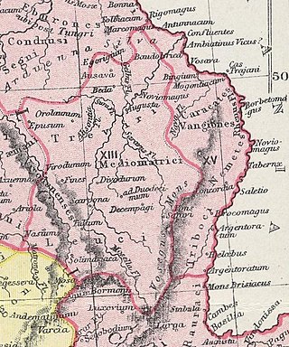
The Nemetes were a tribe settled along the Upper Rhine by Ariovistus in the 1st century BC. Their capital, Noviomagus Nemeton, was close to the site of medieval Speyer.
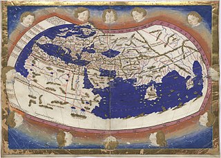
Nicolaus Germanus was a German cartographer who modernized Ptolemy's Geography by applying new projections, adding additional maps, and contributing other innovations that were influential in the development of Renaissance cartography.

Geography is a field of science devoted to the study of the lands, features, inhabitants, and phenomena of Earth. The first recorded use of the word γεωγραφία was as a title of a book by Greek scholar Eratosthenes. Geography is an all-encompassing discipline that seeks an understanding of Earth and its human and natural complexities—not merely where objects are, but also how they have changed and come to be. While geography is specific to Earth, many concepts can be applied more broadly to other celestial bodies in the field of planetary science. One such concept, the first law of geography, proposed by Waldo Tobler, is "everything is related to everything else, but near things are more related than distant things." Geography has been called "the world discipline" and "the bridge between the human and the physical sciences."

Argidava was a Dacian fortress town close to the Danube, inhabited and governed by the Albocense. Located in today's Vărădia, Caraș-Severin County, Romania.
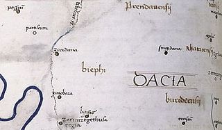
Zurobara was a Dacian town located in the northwest of today's Romanian Banat. It was positioned by the Tibiscus (Timiș) river, north of Sarmizegetusa Regia and south of Ziridava.
The Decree of Dionysopolis was written around 48 BC by the citizens of Dionysopolis to Akornion, who traveled far away in a diplomatic mission to meet somebody's farther in Argedauon. The decree, a fragmentary marble inscription, is located in the National Historical Museum in Sofia.

Geographia Neoteriki is a geography book written in Greek by Daniel Philippidis and Grigorios Konstantas and printed in Vienna in 1791. It focused on both the physical and human geography features of the European continent and especially on Southeastern Europe, and is considered one of the most remarkable works of the modern Greek Enlightenment. The authors of the Geographia Neoteriki adopted new geographical methodologies for that time, which were primarily based on personal examination of the described areas and used as sources a number of contemporary European handbooks.
Geographia Polonica is a peer-reviewed scientific journal published by the Institute of Geography and Spatial Organisation of the Polish Academy of Sciences. The journal is subsidized by the Ministry of Science and Higher Education of Poland.
Technical geography is the branch of geography that involves using, studying, and creating tools to obtain, analyze, interpret, and understand spatial information. The other two branches, human geography and physical geography, can usually apply the concepts and techniques of technical geography. However, the methods and theory are distinct, and a technical geographer may be more concerned with the spatial, technological, and theoretical concepts than the nature of the data. Thus, the spatial data types a technical geographer employs may vary widely, including human and physical geography topics, with the common thread being the techniques and philosophies employed. While technical geography mostly works with quantitative data, the techniques and technology can make use of qualitative datasets, differentiating it from quantitative geography. Within the branch of technical geography are the major and overlapping subbranches of geographic information science, geomatics, and geoinformatics.