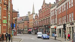
Thame is a market town and civil parish in Oxfordshire, about 13 miles (21 km) east of the city of Oxford and 10 miles (16 km) southwest of Aylesbury. It derives its name from the River Thame which flows along the north side of the town and forms part of the county border with Buckinghamshire. The parish includes the hamlet of Moreton south of the town. The 2011 Census recorded the parish's population as 11,561. Thame was founded in the Anglo-Saxon era and was in the kingdom of Wessex.

Wilmslow Road is a major road in Manchester, England, running from Parrs Wood northwards to Rusholme where it becomes the Oxford Road. The name of the road changes again to Oxford Street when it crosses the River Medlock before reaching Manchester city centre.

Adderbury is a winding linear village and rural civil parish about 3 miles (5 km) south of Banbury in northern Oxfordshire, England. The settlement has five sections: the new Milton Road housing Development and West Adderbury, towards the southwest; East Adderbury to the centre, with a village green and a manor house; the new housing Development on the Aynho Road; the northeast, which is known as Twyford, named after a small outlying settlement by a forked section of the River Cherwell.
Bloxham is a village and civil parish in northern Oxfordshire several miles from the Cotswolds, about 3 miles (5 km) southwest of Banbury. It is on the edge of a valley and overlooked by Hobb Hill. The village is on the A361 road. The 2011 Census recorded the parish's population as 3,374.
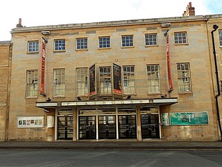
The Oxford Playhouse is a theatre designed by Edward Maufe and F. G. M. Chancellor. It is situated in Beaumont Street, Oxford, opposite the Ashmolean Museum.

Alvescot is a village and civil parish about 1+1⁄2 miles (2.4 km) south of Carterton, Oxfordshire, England. The 2011 Census recorded the parish's population as 472.

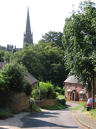
Bampton, also called Bampton-in-the-Bush, is a settlement and civil parish in the Thames Valley about 4+1⁄2 miles (7 km) southwest of Witney in Oxfordshire. The parish includes the hamlet of Weald. The 2011 Census recorded the parish's population as 2,564. Bampton is variously referred to as both a town and a village. The Domesday Book recorded that it was a market town by 1086. It continued as such until the 1890s. It has both a town hall and a village hall.

Finmere is a village and civil parish in Oxfordshire, south of the River Great Ouse. It is on the county boundary with Buckinghamshire, almost 4 miles (6 km) west of Buckingham and just over 4 miles (6 km) east of Brackley in Northamptonshire. The 2011 Census recorded the parish's population as 466.

Broad Street is a wide street in central Oxford, England, just north of the former city wall. The street is known for its bookshops, including the original Blackwell's bookshop at number 50, located here due to the University of Oxford. Among residents, the street is traditionally known as The Broad. On the street is a memorial paving for the Oxford Martyrs.

Walton Street is on the eastern edge of the Jericho district of central Oxford, England.

Middleton Stoney is a village and civil parish about 2+1⁄2 miles (4 km) west of Bicester, Oxfordshire. The 2011 Census recorded the parish's population as 331.

Hythe Bridge Street is in the west of central Oxford, England, forming part of the A4144 road.

St John the Evangelist Church is a non-parochial church on Iffley Road in Oxford, England. It was built as the community church of the mother house of the Anglican religious order known as the Society of St. John the Evangelist. Since 1980 it has served also as one of the college chapels of St Stephen's House, Oxford.

Kencot is a village and civil parish about 2 miles (3 km) south-west of Carterton in West Oxfordshire. The 2011 Census recorded the parish's population as 101.
Harry George Walter Drinkwater (1844–1895) was an English architect who practised in and around Oxford. His work included several churches and public houses.
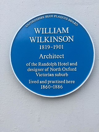
William Wilkinson (1819–1901) was a British Gothic Revival architect who practised in Oxford, England.

Wilcote is a hamlet in the civil parish of North Leigh, in the West Oxfordshire district, in Oxfordshire, England, about 3+1⁄2 miles (5.6 km) north of Witney.

New Road is a street in west central Oxford, England. It links Park End Street and Worcester Street to the west with Queen Street and Castle Street to the east. To the south is Oxford Castle and the former Oxford Prison, now a Malmaison hotel. To the north is Nuffield College, a graduate college of Oxford University. At the eastern end on the south side is New County Hall, the headquarters of Oxfordshire County Council.
Rewley Road is in the west of central Oxford, England. It is located in St Thomas's parish.
Henry James Tollit (1835–1904) was an English architect who practised in Oxford.