George Wallace Tunnel

Last updated
George Wallace Tunnel
Map Mobile River tunnels area.gif
Map of the Wallace (lower) and Bankhead (upper) tunnels under the Mobile River.
Overview
Official name George Corley Wallace Tunnel
Other name(s)Wallace Tunnel
Location Mobile River, Mobile, Alabama
Coordinates 30°41′24″N88°02′08″W / 30.69000°N 88.03556°W / 30.69000; -88.03556
RouteI-10.svg I-10
Operation
OpenedFebruary 9, 1973;50 years ago (1973-02-09)
Traffic78,775 (2015)
CharacterDual four-lane road tunnel
Tollnone
Technical
Length3,000 feet (914 m)
No. of lanes 4
Tunnel clearance 16 feet (5 m)
Depth of tunnel below water level 40 feet (12 m) (from surface to top of tunnel)

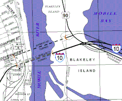
The George Wallace Tunnel is a pair of road tunnels that carry Interstate 10 through Mobile, Alabama from the city's downtown, going beneath the Mobile River, and emerging on Blakeley Island where they join the Jubilee Parkway over Mobile Bay. [1]

Contents

It, like the smaller Bankhead Tunnel a few blocks upriver from it, was constructed in Mobile at the shipyards of the Alabama Drydock and Shipbuilding Company (ADDSCO) from 1969-1973. [1] The George Corley Wallace Tunnel, actually two separate tunnels (one for two lanes of travel eastbound, and one for two lanes of travel westbound on Interstate 10), was built in sections and floated to the proper positions, then sunk. Each section was sunk next to the previous section and joined underwater. When all sections were connected, and concrete set into place, they were pumped dry and finished out. The depth of clearance is 40 ft (12.2 m) for the ship channel over the tunnel. [1] This is the same clearance as the older Bankhead Tunnel.

The tunnel was officially opened to traffic on February 9, 1973, after $50 million ($291.8 million in 2020 dollars) was spent to construct it. [2] It was named after George Wallace, the Governor of Alabama at the time. [2]

Entrances

Interstate 10 eastbound in downtown entering the Wallace Tunnel. Wallace Tunnel Mobile Alabama.jpg
Interstate 10 eastbound in downtown entering the Wallace Tunnel.
Inside of the tunnel, westbound lane. George Wallace Tunnel.jpg
Inside of the tunnel, westbound lane.

The George C. Wallace Tunnel, like the Bankhead Tunnel, emerges on the west end under Royal Street, in downtown Mobile (see map); however, whereas the Bankhead Tunnel emerges at street level joining into Government Street, the George C. Wallace Tunnel slopes upward to continue Interstate 10 as an elevated highway above the Mobile streets. On the eastern end, over Blakeley Island, the George C. Wallace Tunnel again slopes upward becoming the elevated spans of I-10, which cross Mobile Bay eastward, along the twin bridges of the curved I-10 Jubilee Parkway.

The western approach of the tunnel features a sharp curve which causes lengthy traffic backups in each direction depending on demand, and is part of the impetus to study a replacement for the tunnel.

Nearby construction

In the area where the George C. Wallace Tunnel passes beneath downtown Mobile, the re-filled area was later topped with a reconstruction of Fort Conde and several other new buildings, extending from the Mobile River for several blocks, along Water Street and Commerce Street. Because the tunnel tubes emerge within downtown Mobile, the riverbank along the Mobile River appears as an unbroken, continuous waterfront, with no other signs of the tunnels below.

Replacement

The tunnel is expected to be bypassed by a cable-stayed bridge which will be a toll bridge. The existing tunnel will remain as is and will still be in use. [3]

In literature

Author Michael Knight mentions the tunnel in his short story "Our Lady of the Roses," first published in The Southern Review and collected in his Eveningland (2017). He refers to a game Mobile children play whenever they ride through the tunnel. They attempt to hold their breaths all the way through the passage. [4]

See also

Related Research Articles

<span class="mw-page-title-main">Mobile, Alabama</span> City in Alabama, United States

Mobile is a city and the county seat of Mobile County, Alabama, United States. The population within the city limits was 187,041 at the 2020 census, down from 195,111 at the 2010 census. After a successful vote to annex areas west of the city limits in July 2023, Mobile's population increased to 204,689 residents. It is now the second-most-populous city in Alabama, after Huntsville.

<span class="mw-page-title-main">Mobile Bay</span> Inlet of the Gulf of Mexico, lying within the state of Alabama in the United States

Mobile Bay is a shallow inlet of the Gulf of Mexico, lying within the state of Alabama in the United States. Its mouth is formed by the Fort Morgan Peninsula on the eastern side and Dauphin Island, a barrier island on the western side. The Mobile River and Tensaw River empty into the northern end of the bay, making it an estuary. Several smaller rivers also empty into the bay: Dog River, Deer River, and Fowl River on the western side of the bay, and Fish River on the eastern side. Mobile Bay is the fourth largest estuary in the United States with a discharge of 62,000 cubic feet (1,800 m3) of water per second. Annually, and often several times during the summer months, the fish and crustaceans will swarm the shallow coastline and shore of the bay. This event, appropriately named a jubilee, draws a large crowd because of the abundance of fresh, easily caught seafood.

<span class="mw-page-title-main">Interstate 10</span> Interstate Highway across the southern US

Interstate 10 (I-10) is the southernmost transcontinental highway in the Interstate Highway System. I-10 is the fourth-longest Interstate in the United States at 2,460.34 miles (3,959.53 km), following I-90, I-80, and I-40. This freeway is part of the originally planned network that was laid out in 1956, and its last section was completed in 1990.

<span class="mw-page-title-main">Interstate 83</span> Interstate Highway in Pennsylvania and Maryland

Interstate 83 (I-83) is an Interstate Highway located in the states of Maryland and Pennsylvania in the Eastern United States. Its southern terminus is at a signalized intersection with Fayette Street in Baltimore, Maryland; its northern terminus is at I-81 near Harrisburg, Pennsylvania. I-83 runs from Downtown Baltimore north to I-695 near the northern suburb of Timonium on the Jones Falls Expressway before forming a concurrency with I-695. After splitting from I-695, the route follows the Baltimore-Harrisburg Expressway north to the border between Maryland and Pennsylvania. Upon crossing the state line, I-83 becomes the Veterans of Foreign Wars of the United States Memorial Highway and continues north through York toward the Harrisburg area. The route runs along the southern and eastern portion of the Capital Beltway that encircles Harrisburg before reaching its northern terminus.

<span class="mw-page-title-main">Interstate 65</span> Interstate Highway from Alabama to Indiana

Interstate 65 (I-65) is a major north–south Interstate Highway in the central United States. As with most primary Interstates ending in 5, it is a major crosscountry, north–south route, connecting between the Great Lakes and the Gulf of Mexico. Its southern terminus is located at an interchange with I-10 in Mobile, Alabama, and its northern terminus is at an interchange with US 12 (US 12), and US 20 in Gary, Indiana, just southeast of Chicago. I-65 connects several major metropolitan areas in the Midwest and Southern US. It connects the four largest cities in Alabama: Mobile, Montgomery, Birmingham, and Huntsville. It also serves as one of the main north–south routes through Nashville, Tennessee; Louisville, Kentucky; and Indianapolis, Indiana, each a major metropolitan area in its respective state.

<span class="mw-page-title-main">Interstate 278</span> Interstate Highway in New Jersey and New York

Interstate 278 (I-278) is an auxiliary Interstate Highway in New Jersey and New York in the United States. The road runs 35.62 miles (57.32 km) from US Route 1/9 (US 1/9) in Linden, New Jersey, northeast to the Bruckner Interchange in the New York City borough of the Bronx. The majority of I-278 is in New York City, where it serves as a partial beltway and passes through all five of the city's boroughs. I-278 follows several freeways, including the Union Freeway in Union County, New Jersey; the Staten Island Expressway (SIE) across Staten Island; the Gowanus Expressway in southern Brooklyn; the Brooklyn–Queens Expressway (BQE) across northern Brooklyn and Queens; a small part of the Grand Central Parkway in Queens; and a part of the Bruckner Expressway in the Bronx. I-278 also crosses multiple bridges, including the Goethals, Verrazzano-Narrows, Kosciuszko, and Robert F. Kennedy bridges.

<span class="mw-page-title-main">Mobile River</span> River in the United States

The Mobile River is located in southern Alabama in the United States. Formed out of the confluence of the Tombigbee and Alabama rivers, the approximately 45-mile-long (72 km) river drains an area of 44,000 square miles (110,000 km2) of Alabama, with a watershed extending into Mississippi, Georgia, and Tennessee. Its drainage basin is the fourth-largest of primary stream drainage basins entirely in the United States. The river has historically provided the principal navigational access for Alabama. Since construction of the Tennessee-Tombigbee Waterway, it also provides an alternative route into the Ohio River watershed.

<span class="mw-page-title-main">Interstate 295 (Maryland–District of Columbia)</span> Highway in the Washington DC area

Interstate 295 (I-295) in the US state of Maryland and in Washington, D.C., also known as the Anacostia Freeway, is a six-mile (9.7 km) auxiliary Interstate Highway connecting I-95/I-495 and Maryland Route 210 near the Potomac River to I-695 and District of Columbia Route 295 (DC 295) in the Anacostia neighborhood of Washington, D.C.

The Bankhead Highway was a United States cross-country automobile highway connecting Washington, D.C., and San Diego. The Bankhead Highway's beginnings can be traced back to 1916 when the Bankhead Highway Association was organized to promote the highway's development. It was part of the National Auto Trail system. The road was named for Alabama politician John H. Bankhead, a leader in the early national road-building movement. In later years, several stretches of U.S. Route 78 in northwest Alabama were renamed for Bankhead's son, former U.S. Representative and Speaker of the House William B. Bankhead.

<span class="mw-page-title-main">Fort Pitt Tunnel</span> Road tunnel in Pittsburgh, Pennsylvania

The Fort Pitt Tunnel is a vehicular tunnel under Mount Washington in Pittsburgh, Pennsylvania. It connects the West End region on the southwest side to the South Shore neighborhood on the northeast side. The adjoining Fort Pitt Bridge on the northeast end connects to Downtown Pittsburgh. The tunnel carries traffic on Interstate 376 (I-376), U.S. Route 22, US 30, and US 19 Truck. The structure comprises two bores, each with two lanes of traffic. The inbound tunnel flows onto the top deck of the double-deck Fort Pitt Bridge, opposite traffic from the lower deck using the outbound tunnel. To accommodate the bridge, the northeast portals of the parallel tunnels are vertically staggered by 30 feet. The tunnel opened in September 1960, a year after the Fort Pitt Bridge.

<span class="mw-page-title-main">U.S. Route 90 Business (New Orleans, Louisiana)</span> Highway in New Orleans, Louisiana

U.S. Highway 90 Business is a business route of U.S. Highway 90 located in and near New Orleans, Louisiana. It runs 14.25 miles (22.93 km) in a general east–west direction from US 90 in Avondale to a junction with Interstate 10 (I-10) and US 90 in the New Orleans Central Business District.

<span class="mw-page-title-main">Storrow Drive</span> Parkway along the Charles River in Boston

Storrow Drive, officially James Jackson Storrow Memorial Drive, is a major crosstown parkway in Boston, Massachusetts, running east–west along the southern bank of the Charles River. It is restricted to cars; trucks and buses are not permitted on it, while pedestrian access is available via walking paths on the Charles River side of the road. Boston drivers use the route for quick access to downtown locations.

<span class="mw-page-title-main">Bankhead Tunnel</span>

The Bankhead Tunnel, formally the John H. Bankhead Tunnel, is a road tunnel in Mobile, Alabama that carries Government Street under the Mobile River from Blakeley Island to the downtown Mobile business district. It is named for John H. Bankhead, an Alabama politician and U.S. Senator who was also the grandfather of actress Tallulah Bankhead. It, like the larger George Wallace Tunnel a few blocks downriver from it, was constructed in Mobile at the shipyards of the Alabama Drydock and Shipbuilding Company (ADDSCO), from 1938-1940. The eastern end of the Bankhead Tunnel features a large "flood door" that can be closed to prevent water from Mobile Bay flooding the tunnel during surges from hurricanes or tropical storms. It was added to the Alabama Register of Landmarks and Heritage on January 25, 1977.

<span class="mw-page-title-main">Interstate 10 in Alabama</span>

Interstate 10 (I-10) is a part of the Interstate Highway System that runs from Santa Monica, California, to Jacksonville, Florida. In Alabama, the Interstate Highway runs 66.269 miles (106.650 km) from the Mississippi state line near Grand Bay east to the Florida state line at the Perdido River. I-10 is the primary east–west highway of the Gulf Coast region of Alabama. The highway connects Mobile, the largest city in South Alabama, with Pascagoula, Mississippi, to the west and Pensacola, Florida, to the east. Within the state, the highway connects Mobile and Mobile County with the Baldwin County communities of Daphne and Fairhope. I-10 connects Mobile and Baldwin County by crossing the northern end of Mobile Bay and the southern end of the Mobile-Tensaw River Delta via the George Wallace Tunnel in Mobile and the Jubilee Parkway viaduct system between Mobile and Daphne.

<span class="mw-page-title-main">Jubilee Parkway</span> Bridge in Alabama, USA

The Jubilee Parkway is a pair of parallel concrete viaduct bridges that carry Interstate 10 across Mobile Bay from the George Wallace Tunnel on Blakeley Island in Mobile, Alabama eastbound to Spanish Fort/Daphne, Alabama. The bridges are similar in design to the pre-Hurricane Katrina I-10 Twin Span Bridge near New Orleans, Louisiana. Each of the two bridges is two lanes wide, for a total of four lanes, and 7.5 miles (12.1 km) long. The parkway was completed in 1978 and crosses the northern portion of Mobile Bay, running roughly parallel to the nearby Battleship Parkway, with which it has an interchange. It was named for the jubilee phenomenon that occurs intermittently in Mobile Bay, but is commonly referred to locally and in the media as the "Bayway".

Battleship Parkway, commonly referred to locally and in the media as the "Causeway", is a 7-mile (11.3 km) long causeway that carries US 90 and US 98 eastbound across Mobile Bay from the Bankhead Tunnel on Blakeley Island in Mobile, Alabama to Spanish Fort, Alabama. The roadway itself is a four-lane divided highway for most of its length. It is very susceptible to flooding and is usually submerged during hurricane storm surges. The Battleship Parkway is home to Battleship Memorial Park and to many of the Mobile area's more prominent seafood restaurants.

<span class="mw-page-title-main">Conde–Charlotte House</span> Historic house in Alabama, United States

The Conde–Charlotte House, also known as the Kirkbride House, is a historic house museum in Mobile, Alabama. The earliest section of the building, the rear kitchen wing, was built in 1822. The main section of the house was added a few decades later and is two and a half floors. The entire structure is constructed of handmade brick with a smooth stucco plaster over the exterior.

<span class="mw-page-title-main">Government Street (Mobile, Alabama)</span>

Government Street is the name given to portions of U.S. Route 90 (US 90) and US 98 within the city limits of Mobile, Alabama. It is known as Government Boulevard west of Pinehill Drive, and as Government Street east of it. It is the most important road on Mobile's far south side and is the only nominally east–west road on Mobile's south side to enter the city from outside the western city limits and reach the downtown business district. The only other two east–west thoroughfares in the city to do so are Moffett Road/Springhill Avenue and Old Shell Road. Government Street is a four-lane highway throughout the city limits, from Water Street to the western city limits. It is the only thoroughfare in Mobile to have interchanges with both Interstate 10 (I-10) and I-65 within the city limits.

<span class="mw-page-title-main">Blakeley Island (Alabama)</span>

Blakeley Island is an island in the U.S. state of Alabama, within the city limits of Mobile. Located on the northwestern coast of Mobile Bay, it is bounded on the west by the Mobile River, on the south by Pinto Island and Mobile Bay, and on the east and north by the Spanish River. Blakeley serves as a vital road connection point between the Bankhead Tunnel, George Wallace Tunnel, and Cochrane–Africatown USA Bridge on its east side and the Battleship Parkway and Jubilee Parkway on its west side. The northern end is largely undeveloped, while the southern end is dedicated to industrial uses, primarily petrochemical storage and shipbuilding. The largest complex is the shipyards of Austal USA. Approximately 1.25 miles (2.01 km) at its widest and 6 miles (9.7 km) at its longest, it has an average elevation of 7 feet (2.1 m). It, along with downtown, forms District Two of Mobile's city council districts.

References

  1. 1 2 3 "Frequently Asked Questions" (notes), Mobile Area Chamber of Commerce, 2006. MCCOM-FAQ web page Archived 2007-07-17 at the Wayback Machine
  2. 1 2 George C. Wallace Tunnel
  3. "Stalled $2.7B Bridge Project Back on Track in Mobile, Ala. | Engineering News-Record". www.enr.com. Retrieved 2022-09-29.
  4. Knight, Michael. "Our Lady of the Roses," in Eveningland (New York: Grove Press, 2017), 92.