Georgia State Route 283

Last updated

Georgia 283.svg

State Route 283
Georgia state route 283 map.png
Route information
Maintained by GDOT
Length 15.7 mi [1] (25.3 km)
Major junctions
South endGeorgia 60.svg SR 60 northwest of Gainesville
 Georgia 52.svg SR 52 west of Clermont
Georgia 284.svg SR 284 in Clermont
US 129.svgGeorgia 11.svg US 129 / SR 11 in Clermont
North endGeorgia 52.svg SR 52 southeast of Clermont
Location
Counties Hall
Highway system
  • Georgia State Routes
Georgia 282.svg SR 282 SR 284 Georgia 284.svg

State Route 283 (SR 283) is a south-north state highway that runs in a wide arc in the northeastern part of the U.S. state of Georgia. Its route is located entirely within Hall County.

A state highway, state road, or state route is usually a road that is either numbered or maintained by a sub-national state or province. A road numbered by a state or province falls below numbered national highways in the hierarchy. Roads maintained by a state or province include both nationally numbered highways and un-numbered state highways. Depending on the state, "state highway" may be used for one meaning and "state road" or "state route" for the other.

Northeast Georgia

Northeast Georgia is a region of Georgia in the United States. The northern part is also in the north Georgia mountains, while the southern part is still hilly but much flatter in topography. Northeast Georgia is also served by the Asheville/Spartanburg/Greenville/Anderson market.

U.S. state constituent political entity of the United States

In the United States, a state is a constituent political entity, of which there are currently 50. Bound together in a political union, each state holds governmental jurisdiction over a separate and defined geographic territory and shares its sovereignty with the federal government. Due to this shared sovereignty, Americans are citizens both of the federal republic and of the state in which they reside. State citizenship and residency are flexible, and no government approval is required to move between states, except for persons restricted by certain types of court orders. Four states use the term commonwealth rather than state in their full official names.

Contents

Route description

SR 283 begins at an intersection with SR 60 (Thompson Bridge Road) northwest of Gainesville. It heads northeast, crossing the Wahoo Creek arm of Lake Lanier. Then, the route curves to the northwest before curving back to the east. West of Clermont, it shares a brief concurrency with SR 52 (Dahlonega Highway). Farther to the east, in Clermont, SR 283 has an even shorter concurrency with SR 284 (Main Street). Just before leaving Clermont is an intersection with US 129/SR 11 (Cleveland Highway). SR 283 heads southeast until it reaches Skitts Mountain Road. There, it makes a right turn until it meets its northern terminus, a second intersection with SR 52 (Lula Road).

Intersection (road) A road junction where two or more roads either meet or cross at grade

An intersection is an at-grade junction where two or more roads meet or cross. Intersections may be classified by number of road segments, traffic controls, and/or lane design.

Georgia State Route 60 highway in Georgia

State Route 60 (SR 60) is a 90.1-mile-long (145.0 km) state highway that travels southeast-to-northwest through portions of Jackson, Hall, Lumpkin, Union, and Fannin counties in the north-central part of the U.S. state of Georgia. The highway connects the Braselton area with McCaysville at the Tennessee state line, via Gainesville and Dahlonega.

Gainesville, Georgia City in Georgia, United States

The city of Gainesville is the county seat of Hall County, Georgia, United States. As of the 2010 census, the city had a population of 33,804. By 2015 the population had risen to an estimated 38,712. Because of its large number of poultry processing plants, it is often called the "Poultry Capital of the World." Gainesville is the principal city of, and is included in, the Gainesville, Georgia Metropolitan Statistical Area, which is included in the Atlanta-Sandy Springs-Gainesville, Georgia Combined Statistical Area.

History

Major intersections

The entire route is in Hall County.

Locationmi [1] kmDestinationsNotes
0.00.0Georgia 60.svg SR 60 (Thompson Bridge Road)Southern terminus
Wahoo Creek1.42.3Crossing
9.315.0Georgia 52.svg SR 52 west (Dahlonega Highway) Dahlonega Southern end of SR 52 concurrency
West Fork Little River9.515.3Crossing
9.615.4Georgia 52.svg SR 52 east (Dahlonega Highway)Northern end of SR 52 concurrency
Clermont 12.920.8Georgia 284.svg SR 284 south (Main Street) Gainesville Southern end of SR 284 concurrency
13.020.9Georgia 284.svg SR 284 north (Main Street) Cleveland Northern end of SR 284 concurreny
13.321.4US 129.svgGeorgia 11.svg US 129 (Cleveland Highway) / SR 11
15.725.3Georgia 52.svg SR 52 (Lula Road) Clermont, Lula Northern terminus
1.000 mi = 1.609 km; 1.000 km = 0.621 mi

See also

Related Research Articles

Georgia State Route 42 highway in Georgia

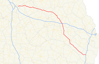
State Route 42 (SR 42) is a 115.3-mile-long (185.6 km) state highway that runs southeast-to-northwest through portions of Peach, Crawford, Monroe, Butts, Henry, Clayton, and DeKalb counties in the central and north-central parts of the U.S. state of Georgia. The route connects Byron with the Atlanta metropolitan area, via McDonough, Stockbridge, and Forest Park.

Georgia State Route 54 highway in Georgia

State Route 54 (SR 54) is a 70.5-mile-long (113.5 km) state highway that runs southwest-to-northeast through portions of Troup, Meriwether, Coweta, Fayette, Clayton, and Fulton counties in the northwestern part of the U.S. state of Georgia. The route connects Hogansville with Atlanta, via Peachtree City, Fayetteville, Jonesboro, and Forest Park.

Georgia State Route 309 highway in Georgia

State Route 309 (SR 309) is a north-south state highway located in the southwestern part of the U.S. state of Georgia. It exists entirely within Decatur County.

Georgia State Route 307 highway in Georgia

State Route 307 (SR 307) is a south-north state highway located in the east central part of the U.S. state of Georgia. The route runs entirely within the Savannah metropolitan area and Chatham County.

Georgia State Route 37 highway in Georgia

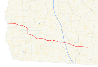
State Route 37 (SR 37) is a 153.6-mile-long (247.2 km) state highway that travels west-to-east through portions of Clay, Calhoun, Baker, Mitchell, Colquitt, Cook, Berrien, Lanier, and Clinch counties in the southwestern and south-central parts of the U.S. state of Georgia. The highway connects the Alabama state line west of Fort Gaines to the Homerville area, via Newton, Camilla, Moultrie, Adel, and Lakeland.

Georgia State Route 39 highway in Georgia

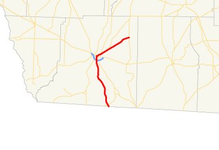
State Route 39 is a 118-mile-long (190 km) state highway that travels south-to-north through portions of Seminole, Miller, Early, Clay, Quitman, and Stewart counties in the southwestern part of the U.S. state of Georgia. The route proceeds north from its southern terminus along the shore of Lake Seminole in southern Seminole County to a point just southwest of Omaha, where it travels in an easterly direction until it meets its northern terminus, an intersection with US 27/SR 1 in the unincorporated community of Louvale Station.

Georgia State Route 44 highway in Georgia

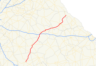
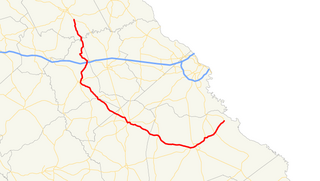
State Route 44 (SR 44) is a 94.2-mile-long (151.6 km) state highway that runs southwest-to-northeast through portions of Jones, Putnam, Greene, Taliaferro, Wilkes, and Lincoln counties in the central and east-central parts of the U.S. state of Georgia. The route connects Gray with the central portion of Lincoln County, northwest of Lincolnton.

Georgia State Route 45 highway in Georgia

State Route 45 (SR 45) is a 88.1-mile-long (141.8 km) state highway that runs south-to-north through portions of Seminole, Miller, Early, Calhoun, Terrell, Webster, and Sumter counties in the southwestern part of the U.S. state of Georgia. The route connects Iron City and Plains, via Colquitt and Dawson.

Georgia State Route 57 highway in Georgia

State Route 57 (SR 57) is a 178.5-mile-long (287.3 km) state highway that travels northwest-to-southeast through portions of Bibb, Jones, Twiggs, Wilkinson, Washington, Johnson, Emanuel, Candler, Tattnall, Long, and McIntosh counties in the central and southeastern parts of the U.S. state of Georgia. The route connects the eastern part of the Macon area to the Eulonia area, via Swainsboro.

Georgia State Route 284 highway in Georgia

State Route 284 (SR 284) is a south-north state highway located in the northeastern part of the U.S. state of Georgia. The route's routing is in Hall and White counties.

Georgia State Route 262 highway in Georgia

State Route 262 (SR 262) is a 44.4-mile-long (71.5 km) L-shaped state highway located in the southwestern part of the U.S. state of Georgia. It travels within portions of within Decatur and Mitchell counties, and skims the border of Grady County.

Georgia State Route 125 highway in Georgia

State Route 125 (SR 125) is a 73-mile-long (117 km) state highway that runs south-to-north in an S-shape through the southern part of the U.S. state of Georgia. It travels through Lowndes, Lanier, Berrien, Tift, Irwin, and Ben Hill counties connecting the Valdosta and Fitzgerald metropolitan areas.

Georgia State Route 88 highway in Georgia

State Route 88 (SR 88) is a 53.2-mile-long (85.6 km) state highway that travels southwest-to-northeast through portions of Washington, Jefferson, Burke, and Richmond counties in the east-central part of the U.S. state of Georgia. The highway connects Sandersville, Wrens, Augusta, and Hephzibah.

Georgia State Route 115 highway in Georgia

State Route 115 (SR 115) is a 32.3-mile-long (52.0 km) state highway that runs west-to-east in the northeastern part of the U.S. state of Georgia. It travels through portions of Lumpkin, White, and Habersham counties.

Georgia State Route 83 highway in Georgia

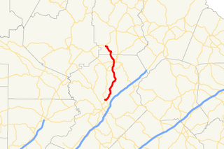
State Route 83 (SR 83) is an 86.5-mile-long (139.2 km) state highway that runs southwest to northeast, with a southeast–to–northwest section, within portions of Monroe, Jasper, Morgan, and Walton counties in the central part of the U.S. state of Georgia. It connects Forsyth, Monticello, and Madison. The portion from the southwestern city limits of Monticello to the Jasper–Morgan county line is included in the Monticello Crossroads Scenic Byway.

Georgia State Route 62 highway in Georgia

State Route 62 (SR 62) is a 62.1-mile-long (99.9 km) state highway in the southwestern part of the U.S. state of Georgia. It connects Columbia, Alabama with Albany.

Georgia State Route 80 highway in Georgia

State Route 80 (SR 80) is a 84.0-mile-long (135.2 km) state highway that predominantly travels in a west–east direction in the east central part of the U.S. state of Georgia. It exists within portions of Wilkes, Warren, Glascock, Jefferson, and Burke counties.

Georgia State Route 105 highway in Georgia

State Route 105 (SR 105) is a 23.1-mile-long (37.2 km) state highway in the northeastern part of the U.S. state of Georgia. The highway begins at the Banks–Franklin–Stephens county tripoint, east-southeast of Baldwin. It ends at Harvest, which is west-northwest of Clarkesville.

Georgia State Route 157 highway in Georgia

State Route 157 (SR 157) is a 39.1-mile-long (62.9 km) state highway that travels south-to-north through portions of Chattooga, Walker, and Dade counties in the northwestern part of the U.S. state of Georgia.

Georgia State Route 126 highway in Georgia

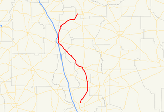
State Route 126 (SR 126) is a 54.9-mile-long (88.4 km) state highway that runs northwest-to-southeast through portions of Bleckley, Dodge, Laurens, and Wheeler counties in the central part of the U.S. state of Georgia.

References

  1. 1 2 Google (February 12, 2013). "Route of SR 283" (Map). Google Maps . Google. Retrieved February 12, 2013.

Route map: Google

KML file (edithelp)
KML is from Wikidata