Georgia State Route 52

Last updated

Georgia 52.svg

State Route 52
Georgia state route 52 map.png
Route information
Maintained by GDOT
Length 124.70 mi [1] (200.68 km)
Major junctions
West endI-75.svgGeorgia 401.svg I75 / SR 401 in Dalton
 US 41.svgGeorgia 3.svg US 41 / SR 3 in Dalton
US 411.svgGeorgia 61.svg US 411 / SR 61 in Chatsworth
Georgia 5.svgGeorgia 515.svg SR 5 / SR 515 in East Ellijay
Georgia 9.svg SR 9 west of Dahlonega
US 129.svgGeorgia 11.svg US 129 / SR 11 southwest of Clermont
US 23.svgGeorgia 365.svg US 23 / SR 365 northwest of Lula
East endGeorgia 98.svg SR 98 in Maysville
Location
Counties Whitfield, Murray, Gilmer, Dawson, Lumpkin, Hall, Banks, Jackson
Highway system
  • Georgia State Routes
Georgia 51.svg SR 51 SR 53 Georgia 53.svg

State Route 52 (SR 52) is a 124.697-mile-long (200.680 km) state highway that runs west–east through portions of Whitfield, Murray, Gilmer, Dawson, Lumpkin, Hall, Banks, and Jackson counties in the northern part of the U.S. state of Georgia. The route runs from its western terminus at Interstate 75 (I-75) in Dalton to its eastern terminus at SR 98 in Maysville.

Whitfield County, Georgia County in the United States

Whitfield County is a county located in the northwestern part of the U.S. state of Georgia. As of the 2010 census shows a population of 102,599. The county seat is Dalton. The county was created on December 30, 1851.

Murray County, Georgia County in the United States

Murray County is a county located in the northwestern part of the U.S. state of Georgia. As of the 2010 census, the population was 39,628. The county seat is Chatsworth.

Gilmer County, Georgia County in the United States

Gilmer County is a county located in the north central portion of the U.S. state of Georgia. As of the 2010 census, the population was 28,292. The county seat is Ellijay. The county was created on December 3, 1832 and was named for George Rockingham Gilmer.

Contents

Route description

Georgia State Route 52 in Whitfield County, with Grassy Mountain in the background Georgia State Rotue 52 in Whitfield County.JPG
Georgia State Route 52 in Whitfield County, with Grassy Mountain in the background

From its western terminus at exit 333 on I-75 in Dalton, SR 52 runs due east along Walnut Avenue into and through downtown Dalton in Whitfield County, curving northeast at Walnut Square Mall to come to its junction with US 76, where it becomes concurrent with US 76. The two routes continue east into Murray County and the northern parts of Chatsworth, where they briefly become co-signed with US 411/SR 2/SR 61, and all five routes travel south into downtown Chatsworth, where SR 52 and SR 2 depart and together continue east into and through Fort Mountain State Park, where the routes are also called Woody Glenn Highway. The routes climb from around 800 feet elevation to above 2,500 feet, before curving to the southeast, passing into and out of Gilmer County twice for very short portions, before finally crossing and staying in Gilmer County, and forming part of the southern border of the Chattahoochee National Forest, then descending into Ellijay. In Ellijay, the two routes cross the Ellijay River together, then SR 52 splits from SR 2 as the route first crosses the Cartecay River just north of where it and the Ellijay River combine to form the Coosawattee River. The route then crosses SR 5/SR 515 and continues southeast, still parallel with the southern reaches of the Chattahoochee National Forest, and runs through rural portions of Gilmer County and northern Dawson County. [1] [2] [3]

Interstate 75 (I-75) in the U.S. state of Georgia travels north–south along the U.S. Route 41 (US 41) corridor on the western side of the state, traveling through the cities of Valdosta, Macon, and Atlanta. It is also designated—but not signed—as State Route 401 (SR 401).

U.S. Route 76 in Georgia highway in Georgia, United States

U.S. Route 76 (US 76) is an 150.7-mile-long (242.5 km) east–west U.S. highway in the U.S. state of Georgia. It begins at the Tennessee state line, east of Lakeview, Georgia, where the roadway continues concurrent with US-41/SR-8 toward Chattanooga. It ends at the South Carolina state line, where US 76 continues toward Anderson. In Georgia, the highway travels within portions of Catoosa, Whitfield, Murray, Gilmer, Fannin, Union, Towns, and Rabun counties. It travels through North Georgia and connects Ringgold, Dalton, Chatsworth, Ellijay, Blue Ridge, Blairsville, and Clayton. Most of the highway is part of the Lookout Mountain Scenic Highway, a highway that travels through northern Georgia and through the Chattahoochee-Oconee National Forest.

Chatsworth, Georgia City in Georgia, United States

Chatsworth is a city in Murray County, Georgia, United States. It is part of the Dalton, Georgia Metropolitan Statistical Area. The population was 3,531 at the 2000 census and 4,299 in 2010. The city is the county seat of Murray County.

Just west of Amicalola Falls State Park, the route assumes an easterly routing at the junction with SR 183, and passes into Lumpkin County, soon thereafter leaving behind the Chattahoochee National Forest. To the west of Dahlonega, SR 52 becomes co-signed with SR 9, and the two routes continue east to Dahlonega, bypassing its downtown to the south and east. Shortly after a brief concurrence with US 19 and SR 60, SR 52 departs and continues east. After a brief concurrency with SR 115 southeast of Dahlonega, the route again assumes a southeasterly course and crosses into Hall County. After passing the community of Clermont to its south, and crossing US 129/SR 11, the route makes a brief turn to the northeast, then curves sharply southeast again, crosses US 23/SR 13, and passes through Lula into Banks County, forming part of the county line between Hall County and Banks County. SR 52 continues southeast through Gillsville, and heads to its eastern terminus in Maysville in Jackson County at its intersection with SR 98. [1] [2] [3]

Amicalola Falls State Park state park in Georgia, United States

Amicalola Falls State Park & Lodge is an 829-acre (3.35 km2) Georgia state park located between Ellijay and Dahlonega in Dawsonville, Georgia. The park's name is derived from a Cherokee language word meaning "tumbling waters". The park is home to Amicalola Falls, a 729-foot (222 m) waterfall that is the highest in Georgia. However, an analysis conducted by the World Waterfall Data base suggests that the main part of the falls is 429 ft (131 m) in height, followed by a prolonged gently sloping run in which the flow drops another 279 ft (85 m). It is considered to be one of the Seven Natural Wonders of Georgia. An 8-mile (13 km) trail that winds past Amicalola Falls and leads to Springer Mountain, famous as the southern terminus of the Appalachian Trail, begins in the park. Amicalola Falls State Park also offers many hiking trails, a guest lodge, restaurant, cabins, a shelter for long-distance Appalachian Trail hikers, a campground, and access to the eco-friendly Len Foote Hike Inn.

Georgia State Route 183 highway in Georgia

State Route 183 (SR 183) is a 10.405-mile-long (16.745 km) state highway that travels south-to-north through portions of Dawson County in the north-central part of the U.S. state of Georgia. The highway extends from its southern terminus at SR 53 west of Dawsonville to its northern terminus at SR 52 south of Amicalola Falls State Park. SR 183, together with SR 136, is the primary feeder route from the south to Amicalola Falls and Amicalola Falls State Park. It is known as Elliot Family Parkway for its entire length, in honor of Dawsonville native racecar drivers Bill Elliott and his son Chase Elliott.

Lumpkin County, Georgia County in the United States

Lumpkin County is a county located in the north central portion of the U.S. state of Georgia. As of the 2010 census, the population was 29,966. Its county seat is Dahlonega.

Traffic

The Georgia Department of Transportation average annual daily traffic (AADT) numbers for the year 2011 show a variety of average daily traffic load numbers as the route travels across northern Georgia. Daily vehicle averages start at the western terminus at I-75 with averages ranging from around 19,000 to a high of 27,600 vehicles per day going from I-75 into and through downtown Dalton, where the route represents the most direct route into Dalton. Averages stay around 25,000 and see their route maximum as SR 52 becomes concurrent with US 76 in Dalton, where nearly 29,000 vehicles travel the route on a daily basis. As the routes travel east to Chatsworth, averages come down to between 15,600 and 18,700 vehicles, and reduce further to 13,600 as the routes meet US 411. East of Chatsworth, as SR 52 starts into the Chattahoochee National Forest, and leaves residential areas, numbers drop drastically, going from 4,600 down to a route low of 620 vehicles as the route traverses Gilmer County. [3]

Georgia Department of Transportation

The Georgia Department of Transportation (GDOT) is the organization in charge of developing and maintaining all state and federal roadways in the U.S. state of Georgia. In addition to highways, the department also has a limited role in developing public transportation and general aviation programs. GDOT is headquartered in downtown Atlanta and is part of the executive branch of state government.

Vehicle load remains well below 1,400 until the route approaches Ellijay, where numbers climb to just above 8,000 vehicles, going to a high of 10,500 as the route crosses SR 5. East of SR 5 the vehicle load drops quickly again down to around 2,700 vehicles as the route crosses into Dawson County, and falls further to just below 1,000 vehicles east of SR 183. As SR 52 crosses into Lumpkin County and approaches Dahlonega, averages again increase to around 2,000 west of Dahlonega, rapidly increasing to just over 10,000 vehicles where the route is concurrent with SR 9. Numbers again drop to around 6,000 east of US 19, then again rapidly drop to around 1,500 into Hall County. Vehicle load increases once more around US 23 to reach 4,000 vehicles per day, drop back down to 1,000 vehicles in Banks County, and see numbers of just over 3,000 at the route's eastern terminus in Maysville. [3]

History

The first portion of the roadway that is signed as SR 52 today makes its appearance on Georgia state road maps in 1920, when the 13.4 miles (21.6 km) portion of the current route from its western terminus to Chatsworth, which is concurrent with US 76, was already in existence, and signed as part of SR2. [4] In 1921, a roadway designated as SR 52 is mapped - covering what today is signed as SR 28 in the Augusta area in east-central Georgia (excluding the portion of SR 28 in northeastern Georgia today). In addition, the 15.6 miles (25.1 km) portion of the current route from Dahlonega, southeast to where it intersects today with US 129, was extant and signed as SR 43 at the time. [5] By the beginning of 1932, the western portion of the route was extended to now feature a new 22.6 miles (36.4 km) section from Chatsworth to Ellijay, also signed as SR 2. In addition, the part of the route between Dahlonega and US 129 was improved to be covered in hard surface, and the part of the route between Dalton and Chatsworth was partially improved at the time. [6] By mid-1932, another major addition had been graded, namely the portion of the route between Ellijay to southwest of Dahlonega. This section was also designated as SR 43, which meant that between the portions of SR 2 and SR 43 that correspond to today's routing, the entire stretch from its western terminus to US 129 in the vicinity of Clermonth was extant. [7]

State Route 2 (SR 2) is a 165-mile-long (266 km) east-west state highway in the far northern part of the U.S. state of Georgia. The highway serves southern suburbs of Chattanooga, Tennessee, as well as much of the mountainous area in the northern part of the state. It traverses the counties of Walker, Catoosa, Whitfield, Murray, Gilmer, Fannin, Union, Towns, and Rabun. It connects Flintstone, in the northwestern part of the state, with the South Carolina state line southeast of Clayton in the northern part and the northeastern part of the state. It also travels through Fort Oglethorpe, Ringgold, Ellijay, Blue Ridge, Blairsville, and Hiawassee. Parts of the highway in the Whitfield and Murray county area are designated as the Cohutta–Chattahoochee Scenic Byway.

Georgia State Route 28 highway in Georgia

State Route 28 (SR 28) is a 25.7-mile-long (41.4 km) state highway in the U.S. state of Georgia. It exists in two distinct segments separated by the northern segment of South Carolina Highway 28 (SC 28), which connects the two segments. The northern segment is located in the northeastern corner of the Chattooga River District of the Chattahoochee-Oconee National Forest. The southern segment is entirely within the Augusta metropolitan area. SR 28 consists of Georgia's segments of a multi-state Route 28 that includes one segment of North Carolina Highway 28 (NC 28) and two segments of SC 28. The northern segment of SR 28 is unnamed, but the southern segment is known as Furys Ferry Road from its western terminus to the intersection with SR 104 Conn. in Augusta, Washington Road in the northern part of Augusta, John C. Calhoun Expressway, Greene Street, 5th Street, and Broad Street in downtown Augusta, and Sand Bar Ferry Road in the northeastern part of Augusta.

Augusta, Georgia Consolidated city-county in Georgia, United States

Augusta, officially Augusta–Richmond County, is a consolidated city-county on the central eastern border of the U.S. state of Georgia. The city lies across the Savannah River from South Carolina at the head of its navigable portion. Georgia's second-largest city after Atlanta, Augusta is located in the Piedmont section of the state.

The roadway around Augusta, which had carried the designation of SR 52, had been re-signed as SR 28 by the middle of 1938. [8] However, it was not until early in 1942 that the section of the route from Ellijay east to Dahlonega, and continuing to US 129, had been re-designated as SR 52, the first appearance of this designation in northwestern and northern Georgia. In addition, a 6.2 miles (10.0 km) portion of roadway had been graded and designated as part of SR 52, running southeast from US 23/SR 13 in Lula to Gillsville in Banks County. As far as road conditions were concerned, hard surface had been added to the portion of the route between Dalton and Chatsworth, and for portions of the route west of SR 183 and west of Dahlonega. [9] The remaining gaps in the route were closed in 1948, when the section of the route between US 129 near Clermont, and US 23/SR 13 in Lula, was graded, and the route was extended from Gillsville to Maysville. With the exception of the new portion between Clermonth and Lula, and small section of the route in Gilmer and Dawson counties, the route had been finished in hard surface at the time. [10] It was then just one more year before the portion of the route between Dalton and Ellijay was re-designated as SR 52, completing the routing and designation of this state highway. [11]

Major intersections

CountyLocationmi [1] kmDestinationsNotes
Whitfield Dalton 0.0000.000I-75.svg I75 (SR 401) Atlanta, Chattanooga Western terminus
5.7229.209US 41.svgUS 76.svgGeorgia 3.svg US 41 / US 76 / SR 3 (N/S Dalton Bypass) Calhoun, Ringgold Western end of US 76 concurrency
7.14611.500Georgia 286.svg SR 286 east (Lower Dawnville Road) Eton Western terminus of SR 286
Murray 9.23814.867Georgia 52 Alternate.svg SR 52 Alt.  Chatsworth
Chatsworth 10.91417.564Georgia 225.svg SR 225  Calhoun
14.00622.540US 411.svgGeorgia 2.svgGeorgia 61.svg US 411 / SR 2 / SR 61 (Hill Street) Eton Western end of US 411/SR 61 and SR 2 concurrencies
15.41224.803US 76.svgUS 411.svgGeorgia 61.svg US 76 / US 411 (3rd Avenue) / SR 61  Fairmount Eastern end of US 411/SR 61 and US 76 concurrencies
Gilmer Ellijay 40.15164.617Georgia 2.svg SR 2 (1st Avenue) Chatsworth Eastern end of SR 2 concurrency
40.60865.352US 76.svgGeorgia 2.svgGeorgia 5.svgGeorgia 515.svg US 76 / SR 2 / SR 5 / SR 515  Jasper, Blue Ridge
Dawson 63.088101.530Georgia 183.svg SR 183 south (Elliot Family Parkway) Dawsonville Northern terminus of SR 183
Lumpkin 73.863118.871Georgia 9.svg SR 9 south (Dawsonville Highway) Dawsonville Western end of SR 9 concurrency
Dahlonega 78.218125.880US 19.svgGeorgia 60.svg US 19 south / SR 60 south (S Chestatee Street)Western end of US 19/SR 60 concurrency
78.962127.077US 19 Business.svgGeorgia 60 Business.svg US 19 Bus. north / SR 60 Bus. north (Main Street)Southern terminus of US 19 Bus./SR 60 Bus.
79.237127.520US 19.svgGeorgia 9.svgGeorgia 60.svg US 19 north / SR 9 north / SR 60 north (Morrison Moore Parkway)Eastern end of concurrency with US 19/SR 60 and SR 9 concurrencies
83.791134.849Georgia 115.svg SR 115 south (Long Branch Road)Western end of SR 115 concurrency
85.968138.352Georgia 115.svg SR 115 north (Dahlonega Highway) Cleveland Eastern end of SR 115 concurrency
Hall 90.735146.024Georgia 283.svg SR 283 south (Mount Vernon Road)Western end of SR 283 concurrency
91.069146.561Georgia 283.svg SR 283 north (Clermont Highway) Clermont Eastern end of SR 283 concurrency
93.327150.195US 129.svgGeorgia 11.svg US 129 (Cleveland Highway) / SR 11  Gainesville, Clermont
94.906152.736Georgia 284.svg SR 284 (Clarks Bridge Road) Gainesville, Clermont
Lula 104.347167.930US 23.svgGeorgia 13.svgGeorgia 365.svg US 23 (Cornelia Highway) / SR 13 / SR 365  Gainesville, Cornelia
105.680170.075Georgia 51.svg SR 51 east (Old Cornelia Highway) Cornelia Western terminus of SR 51
112.289180.712Georgia 323.svg SR 323 west (Gillsville Highway)Western end of SR 323 concurrency
Gillsville 113.505182.669Georgia 323.svg SR 323 eastEastern end of SR 323 concurrency
Banks
No major junctions
Jackson Maysville 124.697200.680Georgia 98.svg SR 98 north (Homer Street) Homer Eastern terminus
1.000 mi = 1.609 km; 1.000 km = 0.621 mi

Bannered route

Chatsworth alternate route

Georgia 52 Alternate.svg

State Route 52 Alternate
Location Chatsworth
Length 5.320 mi [1] (8.562 km)

State Route 52 Alternate (SR 52 Alternate) serves as an alternate route from Dalton into the heart of Chatsworth, while the main routing of SR 52 takes drivers north around the city. It travels from the SR 52 mainline just east of the WhitfieldMurray county line southeast to SR 225, then east into downtown Chatsworth, where it ends at the concurrency of US 76/US 411/SR 52/SR 61. The route also passes by the Chief Vann House Historic Site.


Dahlonega business loop

Georgia 52 Business.svg

State Route 52 Business
Location Dahlonega

See also

Related Research Articles

Georgia State Route 3 highway in Georgia

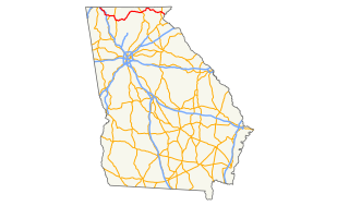
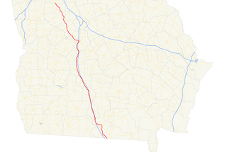
State Route 3 (SR 3) is a 351-mile-long (565 km) state highway that travels south-to-north through portions of the western part of the U.S. state of Georgia, roughly paralleling Interstate 75 (I-75). The highway travels from its southern terminus at the Florida state line, where SR 3 and SR 300 both reach their southern terminus, concurrent with US 19. Here, US 19 travels concurrent with State Road 57, 12 miles (19 km) south-southeast of Thomasville. SR 3 travels through portions of Thomas, Mitchell, Dougherty, Lee, Sumter, Schley, Taylor, Upson, Pike, Spalding, Henry, Clayton, Fulton, Cobb, Bartow, Gordon, Whitfield, and Catoosa counties to its northern terminus at the Tennessee state line, in East Ridge, where US 41/US 76 continue, concurrent with State Route 8. It travels through Thomasville, Albany, Griffin, Atlanta, Calhoun, and Dalton.

Georgia State Route 9 highway in Georgia

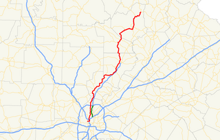
State Route 9 (SR 9), known locally as Highway 9 is an 86.4-mile-long (139.0 km) north–south state highway in the northern part of the U.S. state of Georgia. It travels from Atlanta to Turners Corner, north-northeast of Dahlonega. It is concurrent with U.S. Route 19 (US 19) from its southern terminus, in northwest Atlanta, to Roswell Road at Interstate 285 (I-285), in Sandy Springs. It is also concurrent with US 19 from Dahlonega to its northern terminus at US 129/SR 11.

Georgia State Route 5 highway in Georgia

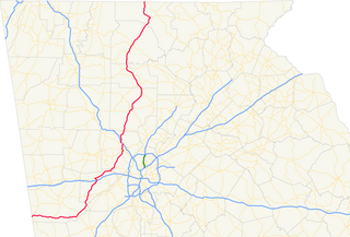
State Route 5 (SR 5) is a 155.325-mile-long (249.971 km) state highway that travels south-to-north through portions of Carroll, Douglas, Cobb, Cherokee, Pickens, Gilmer, and Fannin counties in the western and northern parts of the U.S. state of Georgia. The highway travels from its southern terminus at SR 48 at the Alabama state line, north-northwest of Ephesus, to its northern terminus at SR 60 and SR 68 at the Tennessee state line on the McCaysville–Copperhill line, bisecting the northwestern portion of the state.

Georgia State Route 515 highway in Georgia

State Route 515 (SR 515) is a 76.2-mile-long (122.6 km) four-lane C-shaped state highway in the northern part of the U.S. state of Georgia. It begins just west of Nelson. It curves to the northeast to Lake Chatuge, where it heads north to the North Carolina state line. The highway was built to give motorists in the north Georgia mountains better access to Atlanta and its outlying suburbs, as opposed to the old SR 5 and U.S. Route 76 (US 76) highways, which this project replaced. SR 515 is also known as the Zell Miller Mountain Parkway, in honor of Zell Miller, the Young Harris native turned Georgia governor and U.S. senator. It is one of the Georgia Department of Transportation's Governor's Road Improvement Program (GRIP) corridors. The highway is known for its mountain views all along its route. SR 515 is part of the Appalachian Development Highway System's Corridor A, and is known as the "APD Highway." The highway was designated in 1989.

Georgia State Route 382 highway in Georgia

State Route 382 (SR 382) is a 11.6-mile-long (18.7 km) state highway that travels west-to-east in a squiggly-curved C-shape entirely within Gilmer County in the north-central part of the U.S. state of Georgia. It serves as a connecting route from SR 136 south of Carters Lake to Georgia State Route 5/SR 515 south-southwest of Ellijay. The route can be used to access the southern shores of Carters Lake.

Georgia State Route 323 highway in Georgia

State Route 323 (SR 323) is a 14.1-mile-long (22.7 km) southwest-to-northeast state highway in the northeastern part of the U.S. state of Georgia. Except for the portion in Gillsville, the entire highway travels through rural areas of Hall and Banks counties.

Georgia State Route 7 highway in Georgia

State Route 7 (SR 7) is a 216.0-mile-long (347.6 km) state highway that travels in a southeast-to-northwest orientation through portions of Lowndes, Cook, Tift, Turner, Crisp, Dooly, Houston, Peach, Crawford, Monroe, Lamar, Pike, and Spalding counties in the southern and central parts of the U.S. state of Georgia. The highway connects the Florida state line southeast of Lake Park to the Griffin area, via Valdosta, Tifton, Cordele, Perry, and Barnesville. The highway is concurrent with either US 41 or US 341 for its entire length, and closely parallels I-75 for much of its length.

Georgia State Route 11 highway in Georgia

State Route 11 (SR 11) is a 376-mile-long (605 km) state highway in the U.S. state of Georgia, traveling through portions of Echols, Lanier, Berrien, Irwin, Ben Hill, Wilcox, Pulaski, Houston, Peach, Bibb, Jones, Jasper, Newton, Walton, Barrow, Jackson, Hall, White, Lumpkin, and Union counties. It travels the entire length of the state from south to north, connecting the Florida state line with the North Carolina state line, roughly bisecting the state into two equal parts. It travels through Warner Robins, Macon, and Gainesville It is the longest route in the state. The portion from the southeastern city limits of Monticello to the Jasper–Newton county line is included in the Monticello Crossroads Scenic Byway.

Georgia State Route 17 highway in Georgia

State Route 17 (SR 17) is a 294-mile-long (473 km) state highway that travels south-to-north through portions of Chatham, Effingham, Screven, Jenkins, Burke, Jefferson, Warren, McDuffie, Wilkes, Elbert, Hart, Franklin, Stephens, Habersham, White, and Towns counties in the east-central and northeastern parts of the U.S. state of Georgia. The highway connects Interstate 16 (I-16) in Bloomingdale to the North Carolina state line, northwest of Hiawassee, via Millen, Louisville, Wrens, Thomson, Washington, Elberton, Royston, Toccoa, Clarkesville, and Hiawassee.

Georgia State Route 53 highway in Georgia

State Route 53 (SR 53) is a 172.146-mile-long (277.042 km) west-to-east state highway located in the northern part of the U.S. state of Georgia. The highway travels from the Alabama state line west of Cave Spring northeast, then east, then southeast to US 129 Bus./US 441 Bus./SR 15/SR 24 Bus. in Watkinsville.

Georgia State Route 60 highway in Georgia

State Route 60 (SR 60) is a 90.1-mile-long (145.0 km) state highway that travels southeast-to-northwest through portions of Jackson, Hall, Lumpkin, Union, and Fannin counties in the north-central part of the U.S. state of Georgia. The highway connects the Braselton area with McCaysville at the Tennessee state line, via Gainesville and Dahlonega.

Georgia State Route 61 highway in Georgia

State Route 61 (SR 61) is a 107.1-mile-long (172.4 km) state highway that travels south-to-north through portions of Carroll, Douglas, Paulding, Bartow, Gordon, and Murray counties in the western and northwestern parts of the U.S. state of Georgia. The highway connects the Carrollton area with the Tennessee state line, via Villa Rica, Dallas, Cartersville, and Chatsworth. The portion of the highway from just northeast of Carrollton to Villa Rica was formerly the path of US 78S. When that highway was decommissioned, it was redesignated as US 78 Alternate.

Georgia State Route 98 highway in Georgia

State Route 98 (SR 98) is a 36.6-mile-long (58.9 km) state highway that travels southeast-to-northwest through portions of Madison, Jackson, and Banks counties in the northeastern part of the U.S. state of Georgia. The highway connects Comer and Homer, via Danielsville, Commerce, and Maysville.

U.S. Route 82 in Georgia highway in Georgia

U.S. Route 82 (US 82) is a 232-mile-long (373 km) U.S. Highway in the U.S. state of Georgia. It travels from the Chattahoochee River at Georgetown to its eastern terminus southwest of Brunswick. It travels through such cities as Cuthbert, Dawson, Albany, Sylvester, Tifton, Pearson, Waycross, and Nahunta before reaching its eastern terminus.

U.S. Route 278 in Georgia highway in Georgia

U.S. Route 278 (US 278) in the U.S. state of Georgia is an east–west United States Highway traversing the north-central portion of the state. The highway travels from its western terminus as US 278/SR 74 at the Alabama state line near Esom Hill to its eastern terminus at US 1/US 25/US 78/US 278/SC 121 in the Augusta metropolitan area where it crosses the Savannah River into South Carolina.

Georgia State Route 115 highway in Georgia

State Route 115 (SR 115) is a 32.3-mile-long (52.0 km) state highway that runs west-to-east in the northeastern part of the U.S. state of Georgia. It travels through portions of Lumpkin, White, and Habersham counties.

References

  1. 1 2 3 4 5 "County GIS Base map shapefiles/geodatabases (varies by county)". Georgia Department of Transportation. Retrieved January 22, 2013.
  2. 1 2 Google (November 8, 2012). "GA-52" (Map). Google Maps . Google. Retrieved November 8, 2012.
  3. 1 2 3 4 Geographic Transportation Reporting Analysis and Query System (GeoTRAQS) (Map). Georgia Department of Transportation. Archived from the original on December 27, 2012. Retrieved January 18, 2013.
  4. State of Georgia System of State Roads (PDF) (Map). State Highway Department of Georgia. 1920. Retrieved January 18, 2013.[ permanent dead link ]
  5. Staff. State of Georgia System of State Roads (PDF) (Map) (1921 ed.). State Highway Department of Georgia. Retrieved January 18, 2013.[ permanent dead link ]
  6. State of Georgia System of State Roads (PDF) (Map). State Highway Department of Georgia. January 1932. Retrieved January 18, 2013.[ permanent dead link ]
  7. State of Georgia System of State Roads (PDF) (Map). State Highway Department of Georgia. May 1932. Retrieved January 18, 2013.[ permanent dead link ]
  8. State of Georgia System of State Roads (PDF) (Map). State Highway Department of Georgia. August 1938. Retrieved January 18, 2013.[ permanent dead link ]
  9. State of Georgia System of State Roads (PDF) (Map). State Highway Department of Georgia. January 1, 1942. Archived from the original (PDF) on May 27, 2012. Retrieved January 18, 2013.
  10. State of Georgia System of State Roads (PDF) (Map). State Highway Department of Georgia. February 28, 1948. Retrieved January 18, 2013.[ permanent dead link ]
  11. State of Georgia System of State Roads (PDF) (Map). State Highway Department of Georgia. April 1, 1949. Retrieved January 18, 2013.[ permanent dead link ]

Route map: Google

KML file (edithelp)
KML is from Wikidata