Cornelia, Georgia

Last updated

Cornelia, Georgia
Downtown Cornelia, Georgia.JPG
Downtown Cornelia
Cornelia Seal.jpg
Nickname: 
Home of the Big Red Apple
Habersham County Georgia Incorporated and Unincorporated areas Cornelia Highlighted.svg
Location in Habersham County and the state of Georgia
Coordinates: 34°31′01″N83°31′52″W / 34.51694°N 83.53111°W / 34.51694; -83.53111
Country United States
State Georgia
County Habersham
Blaine1860
CorneliaOctober 22, 1887
Government
  Type Mayoral, elected democratically by popular vote.
  MayorJohn Borrow [1]
  City ManagerDonald Anderson, Jr. [2]
Area
[3]
  Total4.20 sq mi (10.87 km2)
  Land4.15 sq mi (10.75 km2)
  Water0.05 sq mi (0.12 km2)
Elevation
[4]
1,486 ft (453 m)
Population
 (2020)
  Total4,503
  Density1,085.06/sq mi (418.95/km2)
Time zone UTC-5 (Eastern (EST))
  Summer (DST) UTC-4 (EDT)
ZIP code
30531
Area code 706
FIPS code 13-19728 [5]
GNIS feature ID2404133 [4]
Website corneliageorgia.org

Cornelia is a city in Habersham County, Georgia, United States. The population was 4,160 at the 2010 census, [6] up from 3,674 at the 2000 census. It is home to one of the world's largest apple sculptures, which is displayed on top of an obelisk-shaped monument. Cornelia was the retirement home of baseball legend Ty Cobb who was born nearby, and was a base of operation for production of the 1956 Disney film The Great Locomotive Chase that was filmed along the Tallulah Falls Railway that ran from Cornelia northward along the rim of Tallulah Gorge to Franklin, North Carolina.

Contents

Geography

Cornelia is located in southern Habersham County and is bordered to the east by Mount Airy and to the southwest by Baldwin.

According to the United States Census Bureau, the city has a total area of 4.0 square miles (10.3 km2), of which 0.04 square miles (0.1 km2), or 1.06%, are water. [6]

Climate

Climate data for Cornelia, Georgia, 1991–2020 normals, extremes 1919present
MonthJanFebMarAprMayJunJulAugSepOctNovDecYear
Record high °F (°C)80
(27)
79
(26)
78
(26)
91
(33)
96
(36)
102
(39)
103
(39)
100
(38)
99
(37)
93
(34)
85
(29)
77
(25)
103
(39)
Mean maximum °F (°C)66.6
(19.2)
69.5
(20.8)
77.3
(25.2)
82.6
(28.1)
86.4
(30.2)
91.0
(32.8)
92.8
(33.8)
92.1
(33.4)
88.8
(31.6)
82.4
(28.0)
75.5
(24.2)
67.4
(19.7)
93.8
(34.3)
Mean daily maximum °F (°C)49.3
(9.6)
53.0
(11.7)
60.4
(15.8)
69.0
(20.6)
75.9
(24.4)
82.4
(28.0)
85.6
(29.8)
84.1
(28.9)
79.0
(26.1)
69.9
(21.1)
60.2
(15.7)
52.0
(11.1)
68.4
(20.2)
Daily mean °F (°C)39.8
(4.3)
43.1
(6.2)
49.7
(9.8)
57.9
(14.4)
65.5
(18.6)
72.7
(22.6)
76.1
(24.5)
74.8
(23.8)
69.4
(20.8)
59.3
(15.2)
49.5
(9.7)
42.8
(6.0)
58.4
(14.7)
Mean daily minimum °F (°C)30.4
(−0.9)
33.1
(0.6)
39.0
(3.9)
46.8
(8.2)
55.1
(12.8)
62.9
(17.2)
66.5
(19.2)
65.5
(18.6)
59.7
(15.4)
48.8
(9.3)
38.8
(3.8)
33.6
(0.9)
48.4
(9.1)
Mean minimum °F (°C)13.9
(−10.1)
18.9
(−7.3)
24.6
(−4.1)
33.2
(0.7)
42.2
(5.7)
54.5
(12.5)
60.9
(16.1)
59.9
(15.5)
48.6
(9.2)
34.9
(1.6)
26.2
(−3.2)
20.7
(−6.3)
11.9
(−11.2)
Record low °F (°C)−10
(−23)
−4
(−20)
5
(−15)
18
(−8)
29
(−2)
39
(4)
50
(10)
46
(8)
30
(−1)
23
(−5)
7
(−14)
−1
(−18)
−10
(−23)
Average precipitation inches (mm)5.46
(139)
5.05
(128)
5.61
(142)
4.39
(112)
3.92
(100)
5.12
(130)
4.70
(119)
5.60
(142)
4.39
(112)
4.76
(121)
4.45
(113)
5.49
(139)
58.94
(1,497)
Average snowfall inches (cm)0.1
(0.25)
0.2
(0.51)
0.0
(0.0)
0.0
(0.0)
0.0
(0.0)
0.0
(0.0)
0.0
(0.0)
0.0
(0.0)
0.0
(0.0)
0.0
(0.0)
0.0
(0.0)
0.3
(0.76)
0.6
(1.52)
Average precipitation days (≥ 0.01 in)9.810.410.59.49.410.810.910.97.77.08.110.2115.1
Average snowy days (≥ 0.1 in)0.10.00.00.00.00.00.00.00.00.00.00.10.2
Source 1: NOAA [7]
Source 2: National Weather Service [8]

History

Cornelia was originally called "Blaine", and under the latter name had its start in the early 1870s when the Charlotte Airline Railroad was extended to that point. [9] The Georgia General Assembly incorporated the place in 1887 as the "Town of Cornelia". [10]

Lore

Cornelia abounds in historical lore. Near the city is the Wofford Trail, on which many stagecoach robberies occurred. The last railroad holdup in Georgia took place at Cagle's Crossing, which is a few miles south of Cornelia. [11] The whole of Habersham County was extremely loyal to the Confederacy and was known, along with the Shenandoah Valley of Virginia and countless other fertile, out-of-the-way places as the "breadbasket of the Confederacy", as thousands of bushels of wheat and corn were supplied to the troops from this area alone. After the Fall of Atlanta, a detachment of William Tecumseh Sherman's cavalry was sent to raid the county; but the Confederate Home Guard, made up of men too old for military duty, left the mountains on which Cornelia is situated and met the Union soldiers at a narrow pass about four miles east of the town. By making considerable noise and stirring up clouds of smoke, they scared off the Union soldiers and saved the area from complete devastation. Today this skirmish is remembered as "The Battle of the Narrows". [12]

Education

Cornelia has been helped in its growth by its good schools. [ citation needed ] In the early days, the school system was owned and operated by the town of Cornelia. Each student provided their books and paid a tuition fee, half payable before Christmas, with the balance due after Christmas. The school principal would determine what books would be needed and would then send someone to Atlanta to order books and supplies personally from the publishers (Maxwell, p. 4).[ citation needed ] Among the first schools was the Kimsey Institute, located on land given by T.J. Kimsey. The First Baptist Church was organized there; for many years it was used for both school and church. Willie Grant and J.T. Wise were two of the early teachers. After attendance outgrew the early frame building in 1897, another school was built with Professor A.E. Booth elected as principal. According to the document published by the Habersham County Department of Education in 1937, Professor Booth added a training course for teachers, and students were attracted to this school from all sections of northeast Georgia (p. 21). Cornelia Normal Institute was chartered on May 27, 1901. In 1952, the schools in Habersham were consolidated. The elementary schools had been kept in each town but two high schools were built, one to serve each end of the county. Prior to 1952, Cornelia Public School served all the students residing in Cornelia. The high school curriculum included college preparatory and business classes, athletics for both males and females, music, and "expression" (speech classes). The school's first graduates were in the Class of 1899 and included Martin L. York, Charles Crunkleton, Calvania T. York, Albert N. McConnell, Wylie G. Light, and Ida K. Baugh.[ citation needed ]

German and Swiss immigrants used their wine-making skills to create an industry in the 1880s that flourished until a prohibition law stopped it. Cotton, timber and lumber products, and the apple and peach industries were also important to the success of the area. Riegel Textile built one of the region's first major industrial facilities in 1966 with what was then an ultra-modern, cutting edge textile mill designed by Bill Pittendreigh in the neighboring community of Alto. As with any city, there were a number of businesses, but hotels contributed greatly to the growth and development of the city in its early history.[ citation needed ]

The Big Red Apple

Big Red Apple Cornelia, Georgia Big Red Apple.JPG
Big Red Apple

Cornelia's Big Red Apple, located at the old train depot in downtown, pays homage to the apple and apple growers of the county. Built of steel and concrete in 1925, the statue, according to Habersham County, weighs 5,200 pounds (2.4 t) and is 7 feet (2.1 m) high.

Towards the end of World War I, "extension agents" began to play a very important role in northeast Georgia. These people, as a group, supported the end of the one-crop (cotton) economy. Throughout the state they began to educate farmers in crop diversification so that if one crop failed income from other crops could support the family. In Gwinnett, Cherokee and Hall counties, farmers increased production of dairy products. The peach crop in Bartow County was expanded. In Habersham and Gilmer counties farmers increased production of apples and peaches.

The extension agents' push for this diversity seemed almost prescient, for in 1922 the boll weevil began the systematic destruction of cotton crops in the state of Georgia. By 1924 cotton output had dropped to 50% of earlier levels. In 1925 the people of Cornelia realized that the apple had been a key in preventing the scourge that destroyed other counties and drove rural families to cities like Atlanta and Macon. The concept for the statue was born, thanks in part to the newly formed Kiwanis Club.

At the dedication on June 4, 1926, many notables attended, including Senator Walter F. George. Because apple sales were off dramatically, in 1932 local farmers decided to put them in cold storage until the following spring, but the sales did not materialize, so the farmers were not only out the cost of raising the crop, they were also out the cost of storing the crop. By the summer of 1933, the apples that had saved the county less than 10 years earlier nearly destroyed it.

Through the years downtown Cornelia changed dramatically. As the railroad era passed the old depot was closed and boarded up, and the once central location was only a side street. A recent renovation has brought the depot back to life, and the quiet Big Red Apple is the focal point of a yearly festival [13] held the first week in October and a 5K road race held at the end of October.

Demographics

Historical population
CensusPop.Note
1890 175
1900 467166.9%
1910 1,114138.5%
1920 1,27414.4%
1930 1,54221.0%
1940 1,80817.3%
1950 2,42434.1%
1960 2,93621.1%
1970 3,0142.7%
1980 3,2036.3%
1990 3,2190.5%
2000 3,67414.1%
2010 4,16013.2%
2020 4,5038.2%
U.S. Decennial Census [14]

2020 census

Cornelia Racial Composition [15]
RaceNum.Perc.
White 2,04745.46%
Black or African American 2956.55%
Native American 80.18%
Asian 2064.57%
Pacific Islander 10.02%
Other/Mixed 1473.26%
Hispanic or Latino 1,79939.95%

As of the 2020 United States Census, there were 4,503 people, 1,365 households, and 871 families residing in the city.

2010 census

As of the census [5] of 2010, there were 4,160 people, 1,495 households, and 1,495 families residing in the city. The population density was 1,071.3 inhabitants per square mile (413.6/km2). There were 1,728 housing units at an average density of 469.7 per square mile (181.4/km2). The racial makeup of the city was 67.7% White, 5.7% African American, 0.9% Native American, 4.2% Asian (3.0% Laotian), 0.6% Pacific Islander, 16.5% from other races, and 4.4% from two or more races. Hispanic or Latino of any race were 34.8% of the population (26.7% Mexican).

There were 1,016 households, out of which 24.4% had children under the age of 18 living with them, 47.4% were married couples living together, 12.6% had a female householder with no husband present, and 35.6% were non-families. 32.1% of all households were made up of individuals, and 17.5% had someone living alone who was 65 years of age or older. The average household size was 2.47 and the average family size was 3.09.

In the city, the population was spread out, with 23.4% under the age of 18, 11.0% from 18 to 24, 26.4% from 25 to 44, 21.7% from 45 to 64, and 17.5% who were 65 years of age or older. The median age was 37 years. For every 100 females, there were 93.8 males. For every 100 females age 18 and over, there were 89.2 males.

The median income for a household in the city was $31,111, and the median income for a family was $42,041. Males had a median income of $25,505 versus $20,404 for females. The per capita income for the city was $21,701. About 8.8% of families and 13.3% of the population were below the poverty line, including 15.1% of those under age 18 and 20.2% of those age 65 or over.

Related Research Articles

<span class="mw-page-title-main">Clay County, Arkansas</span> County in Arkansas, United States

Clay County is a county located in the U.S. state of Arkansas. Originally incorporated as Clayton County, as of the 2020 census, its population was 14,552. The county has two county seats, Corning and Piggott. It is a dry county, in which the sale of alcoholic beverages is restricted or prohibited.

<span class="mw-page-title-main">White County, Georgia</span> County in Georgia, United States

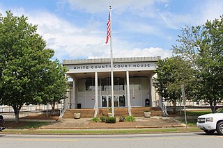
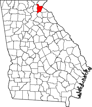
White County is a county located in the northeastern part of the U.S. state of Georgia. As of the 2020 census, the population was 28,003. The county seat is Cleveland. The county was created on December 22, 1857, formerly a part of Habersham County and most likely was named for Newton County Representative David T. White, who helped a Habersham representative successfully attain passage of an act creating the new county.

<span class="mw-page-title-main">Habersham County, Georgia</span> County in Georgia, United States

Habersham County is a county located in the northeastern part of the U.S. state of Georgia. As of the 2020 census, the population was 46,031. The county seat is Clarkesville. The county was created on December 15, 1818, and named for Colonel Joseph Habersham of the Continental Army in the Revolutionary War.

<span class="mw-page-title-main">Banks County, Georgia</span> County in Georgia, United States

Banks County is a county located in the northeastern part of the U.S. state of Georgia. As of the 2020 census, the population was 18,035, down from 18,395 in 2010. The county seat is Homer. The Old Banks County Courthouse is located in Homer and listed on the National Register of Historic Places. A new county courthouse was constructed adjacent to the old one in 1983.

<span class="mw-page-title-main">Hughson, California</span> City in California, United States

Hughson is a city in Stanislaus County, California, United States. It is part of the Modesto Metropolitan Statistical Area. The population was 7,481 at the 2020 census, up from 6,640 at the 2010 census.

<span class="mw-page-title-main">Alto, Georgia</span> Town in Georgia, United States

Alto is a town in Banks and Habersham counties in the U.S. state of Georgia. As of the 2010 census, the town had a population of 1,172, up from 876 at the 2000 census.

<span class="mw-page-title-main">Baldwin, Georgia</span> City in Georgia, United States

Baldwin is a city in Banks and Habersham counties in the U.S. state of Georgia. As of the 2010 census, the city had a population of 3,279, up from 2,425 at the 2000 census.

<span class="mw-page-title-main">Moreland, Georgia</span> Town in Georgia, United States

Moreland is a town in Coweta County, Georgia, United States. As of the 2020 census, the town population was 382.

<span class="mw-page-title-main">Brooks, Georgia</span> Town in Georgia, United States

Brooks is a town in Fayette County, Georgia, United States. As of the 2020 United States census, it had a population of 568.

<span class="mw-page-title-main">Clarkesville, Georgia</span> City in Georgia, United States

Clarkesville is a city that is the county seat of Habersham County, Georgia, United States. As of the 2020 census, it had a population of 1,911, up from the 2010 census population of 1,733, up from 1,248 at the 2000 census.

<span class="mw-page-title-main">Demorest, Georgia</span> City in Georgia, United States

Demorest is a city in Habersham County, Georgia, United States. The population was 2,022 at the 2020 census, up from 1,823 at the 2010 census, and 1,465 at the 2000 census. It is the home of Piedmont University.

<span class="mw-page-title-main">Mount Airy, Georgia</span> Town in Georgia, United States

Mount Airy is a town in Habersham County, Georgia, United States. The population was 1,284 at the 2010 census, up from 604 at the 2000 census.

<span class="mw-page-title-main">Raoul, Georgia</span> Place in Georgia, United States

Raoul is an unincorporated community and census-designated place (CDP) in Habersham County, Georgia, United States. As of the 2010 census, the CDP had a population of 2,558, up from 1,816 at the 2000 census.

<span class="mw-page-title-main">Ila, Georgia</span> City in Georgia, United States

Ila is a city in Madison County, Georgia, United States. The population was 350 at the 2020 census.

<span class="mw-page-title-main">Fort Valley, Georgia</span> City in Georgia, United States

Fort Valley is a city in and the county seat of Peach County, Georgia, United States. As of the 2020 census, the city had a population of 8,780.

<span class="mw-page-title-main">Concord, Georgia</span> City in Georgia, United States

Concord is a city in Pike County, Georgia, United States. The population was 375 at the 2010 census.

<span class="mw-page-title-main">Campbell, Missouri</span> City in Missouri, United States

Campbell is a city in northern Dunklin County, Missouri, United States. The population was 1,992 at the 2010 census.

<span class="mw-page-title-main">Ryan, Oklahoma</span> Town in Oklahoma, United States

Ryan is a town in Jefferson County, Oklahoma, United States, located just north of the Texas state line. The population was 667 at the 2020 census.

<span class="mw-page-title-main">Burton, Texas</span> City in Texas, United States

Burton is a city in Washington County, Texas, United States. The population was 359 at the 2000 census. Prior to the 2010 census, Burton changed its status from a town to a city. The population was 300 at the 2010 census.

<span class="mw-page-title-main">Lytle, Texas</span> City in Atascosa, Bexar, and Medina counties in Texas, U.S.

Lytle is a city in Atascosa, Bexar, and Medina counties in the U.S. state of Texas. The population was 2,492 at the 2010 census. It is part of the San Antonio Metropolitan Statistical Area.

References

  1. "Mayor and Commission". City of Cornelia. 2020. Archived from the original on August 31, 2009. Retrieved September 21, 2009.
  2. "City Manager's Office". City of Cornelia. 2009. Archived from the original on July 25, 2011. Retrieved September 21, 2009.
  3. "2020 U.S. Gazetteer Files". United States Census Bureau. Retrieved December 18, 2021.
  4. 1 2 U.S. Geological Survey Geographic Names Information System: Cornelia, Georgia
  5. 1 2 "U.S. Census website". United States Census Bureau . Retrieved January 31, 2008.
  6. 1 2 "Geographic Identifiers: 2010 Demographic Profile Data (G001): Cornelia city, Georgia". American Factfinder. U.S. Census Bureau. Retrieved May 15, 2017.[ dead link ]
  7. "U.S. Climate Normals Quick Access – Station: Cornelia, GA". National Oceanic and Atmospheric Administration. Retrieved March 4, 2023.
  8. "NOAA Online Weather Data – NWS Greenville". National Weather Service. Retrieved March 4, 2023.
  9. Krakow, Kenneth K. (1975). Georgia Place-Names: Their History and Origins (PDF). Macon, GA: Winship Press. p. 52. ISBN   0-915430-00-2.
  10. Bulletin of the New York Public Library. New York Public Library. 1912. p. 697.
  11. "The Wofford Trail". The Cartersville News. July 1, 1909
  12. "The Battle of the Narrows". The GAGenWeb Project
  13. "Big Red Apple". City of Cornellia. Retrieved January 19, 2017.
  14. "Census of Population and Housing". Census.gov. Retrieved June 4, 2015.
  15. "Explore Census Data". data.census.gov. Retrieved December 7, 2021.