Eton, Georgia | |
---|---|
Coordinates: 34°49′21″N84°45′43″W / 34.82250°N 84.76194°W | |
Country | United States |
State | Georgia |
County | Murray |
Area | |
• Total | 1.28 sq mi (3.32 km2) |
• Land | 1.28 sq mi (3.32 km2) |
• Water | 0.00 sq mi (0.00 km2) |
Elevation | 748 ft (228 m) |
Population | |
• Total | 824 |
• Density | 643.75/sq mi (248.47/km2) |
Time zone | UTC-5 (Eastern (EST)) |
• Summer (DST) | UTC-4 (EDT) |
ZIP code | 30724 |
Area code(s) | 706/762 |
FIPS code | 13-27932 [4] |
GNIS feature ID | 0331673 [2] |
Website | www |
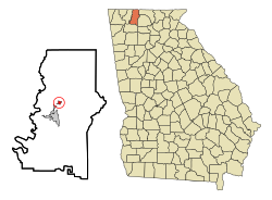
Eton is a town in Murray County, Georgia, United States. It is part of the Dalton, Georgia Metropolitan Statistical Area. The population was 824 at the 2020 census, [3] down from 910 in 2010.
A post office called Eton has been in operation since 1906. [5] The community's name most likely is a transfer from Eton College, in England. [6]
Eton is located north of the center of Murray County at 34°49′21″N84°45′43″W / 34.82250°N 84.76194°W (34.822554, -84.761826). [7] U.S. Route 411 passes through the center of town, leading south 4 miles (6 km) to Chatsworth, the county seat, and north 21 miles (34 km) to Ocoee, Tennessee. Georgia State Route 286 leads west from Eton 7 miles (11 km) to Dawnville.
According to the United States Census Bureau, Eton has a total area of 1.3 square miles (3.4 km2), all land. [1] Mill Creek runs through the southern part of the town, flowing west toward the Conasauga River. 1,030-foot (310 m) Camp Ground Mountain rises above the town to the south.
Census | Pop. | Note | %± |
---|---|---|---|
1910 | 307 | — | |
1920 | 313 | 2.0% | |
1930 | 259 | −17.3% | |
1940 | 239 | −7.7% | |
1950 | 297 | 24.3% | |
1960 | 275 | −7.4% | |
1970 | 286 | 4.0% | |
1980 | 301 | 5.2% | |
1990 | 315 | 4.7% | |
2000 | 319 | 1.3% | |
2010 | 910 | 185.3% | |
2020 | 824 | −9.5% | |
U.S. Decennial Census [8] |
As of the census [4] of 2000, there were 319 people, 123 households, and 93 families residing in the town. The population density was 762.1 inhabitants per square mile (294.2/km2). There were 131 housing units at an average density of 313.0 per square mile (120.8/km2). The racial makeup of the town was 94.04% White, 0.31% Asian, 4.39% from other races, and 1.25% from two or more races. Hispanic or Latino of any race were 11.29% of the population.
There were 123 households, out of which 35.0% had children under the age of 18 living with them, 56.9% were married couples living together, 15.4% had a female householder with no husband present, and 23.6% were non-families. 18.7% of all households were made up of individuals, and 5.7% had someone living alone who was 65 years of age or older. The average household size was 2.59 and the average family size was 2.87.
The population was spread out, with 24.8% under the age of 18, 8.5% from 18 to 24, 34.2% from 25 to 44, 22.6% from 45 to 64, and 10.0% who were 65 years of age or older. The median age was 35 years. For every 100 females, there were 84.4 males. For every 100 females age 18 and over, there were 86.0 males.
The median income for a household was $39,250, and the median income for a family was $46,389. Males had a median income of $31,625 versus $22,813 for females. The per capita income for the city was $17,777. About 3.3% of families and 4.4% of the population were below the poverty line, including none of those under age 18 and 2.4% of those age 65 or over.
East Foothills is a census-designated place (CDP) in Santa Clara County, California, United States and a neighborhood of San Jose. The population was 8,269 at the 2010 census and it is located about 4 miles east of downtown San Jose.
Holly Springs is a city in Cherokee County, Georgia, United States. The population was 9,189 as of the 2010 census, up from 3,195 in 2000.
Nelson is a city in Pickens and Cherokee Counties, Georgia, United States. At the 2020 census, the population was 1,145. It is part of the Atlanta metropolitan area.
Waleska is a city in Cherokee County, Georgia, United States. The population was 644 at the 2010 census.
Sharpsburg (ˈʃɑrpsbɝg) is a town in Coweta County, Georgia, United States. It is part of the Atlanta metropolitan area. Its population was 327 at the 2020 census.
Morganton is a city in Fannin County, Georgia, United States. The population was 285 at the 2020 census.
Bowersville is a town in Hart County, Georgia, United States. As of the 2020 census, the town had a population of 444.
Pendergrass is a city in Jackson County, Georgia, United States. The population was 1692 at the time of the 2020 census.
Gay is a town in Meriwether County, Georgia, United States. The population was 110 at the 2020 census.
Lone Oak is a town in Meriwether County, Georgia, United States. The population was 114 at the 2020 census.
Talking Rock is a town in Pickens County, Georgia, United States. The population is 91.
Williamson is a city in Pike County, Georgia, United States. The population was 352 at the 2010 census.
Lincoln Township is a civil township of Isabella County in the U.S. state of Michigan. The population was 2,069 at the 2020 census.
Perry is a town in Aiken County, South Carolina, United States. The population was 233 at the 2010 census. It is part of the Augusta, Georgia metropolitan area.
Winfield is a town in Scott County, Tennessee, United States. Originally named Chitwood in the late 18th century for Revolutionary War hero Captain James Chitwood after his family settled the area extensively, the name was changed following the Civil War due to the family's mixed allegiances. The name Winfield was picked in honor of US army general Winfield Scott. The population was 947 at the 2020 census and 967 at the 2010 census.
Edinburg is a town in Shenandoah County, Virginia, United States. The population was 1,041 at the 2010 census.
Rusk is a town in Rusk County, Wisconsin, United States. The population was 475 at the 2000 census. The unincorporated community of Bear Lake is located in the town.
Chilton is a town in Calumet County in the U.S. state of Wisconsin. The population was 1,143 at the 2010 census. The City of Chilton is located partially within the town. The unincorporated community of Brant is located in the town.
Oconto Falls is a town in Oconto County, Wisconsin, United States. The population was 1,139 at the 2000 census. The City of Oconto Falls is located within the town.
Radisson is a town in Sawyer County, Wisconsin, United States. The population was 465 at the 2000 census. The Village of Radisson is located within the town.