Georgia State Route 65

Last updated

Georgia 65.svg

State Route 65
Georgia state route 65 map.png
Route information
Maintained by Georgia Department of Transportation
Length 17.0 mi [1] (27.4 km)
Major junctions
West endGeorgia 311.svg SR 311 west of Hopeful
 Georgia 112.svg SR 112 south-southwest of Camilla
East endGeorgia 93.svg SR 93 in Pelham
Location
Counties Mitchell
Highway system
  • Georgia State Routes
Georgia 64.svg SR 64 SR 66 Georgia 66.svg

State Route 65 (SR 65) is a 17.0-mile-long (27.4 km) state highway located entirely in the southwestern part of Mitchell County in the southwestern part of the U.S. state of Georgia. It connects the Hopeful and Pelham areas of the state.

Mitchell County, Georgia County in the United States

Mitchell County is a county in the U.S. state of Georgia. As of the 2010 census, the population was 23,498. The county seat is Camilla. Mitchell County was created on December 21, 1857. It was named for David Brydie Mitchell, 27th Governor of Georgia.

Southwest Georgia

Southwest Georgia is a fourteen-county region in the U.S. state of Georgia. It has a 2010 census population of 496,433, and is the least populated region in Georgia, just slightly behind Southeast Georgia. Additionally, the area has historically been the poorest region of the state since at least 1995, when over 25% of the residents were in poverty.

U.S. state constituent political entity of the United States

In the United States, a state is a constituent political entity, of which there are currently 50. Bound together in a political union, each state holds governmental jurisdiction over a separate and defined geographic territory and shares its sovereignty with the federal government. Due to this shared sovereignty, Americans are citizens both of the federal republic and of the state in which they reside. State citizenship and residency are flexible, and no government approval is required to move between states, except for persons restricted by certain types of court orders. Four states use the term commonwealth rather than state in their full official names.

Contents

Route Description

SR 65 begins at an intersection with SR 311, west of Hopeful. It heads southeast and curves to the east toward Pelham. The route has an intersection with SR 97 in Hopeful. The highway travels east-southeast through rural portions of the county and passes through the town of Branchville. It has an intersection with SR 112 before reaching Pelham. Once in Pelham, the route gradually bends to the east-southeast, until it meets its eastern terminus, an intersection with SR 93.

Intersection (road) A road junction where two or more roads either meet or cross at grade

An intersection is an at-grade junction where two or more roads meet or cross. Intersections may be classified by number of road segments, traffic controls, and/or lane design.

Georgia State Route 311 highway in Georgia

State Route 311 (SR 311) is a north-south state highway located in the southwest part of the U.S. state of Georgia.

Georgia State Route 97 highway in Georgia

State Route 97 (SR 97) is a southwest-northeast state highway in the southwest part of the U.S. state of Georgia. The highway runs 57.2 miles (92.1 km) from its southern terminus at the Florida state line, southwest of Faceville, where the roadway continues as County Road 269A, northeast through Bainbridge to its northern terminus, in Camilla.

SR 65 is not part of the National Highway System, a system of roadways important to the nation's economy, defense, and mobility. [2]

National Highway System (United States) highway system in the United States

The National Highway System (NHS) is a network of strategic highways within the United States, including the Interstate Highway System and other roads serving major airports, ports, rail or truck terminals, railway stations, pipeline terminals and other strategic transport facilities. Altogether, it constitutes the largest highway system in the world.

Major intersections

The entire route is in Mitchell County.

Locationmi [1] kmDestinationsNotes
0.00.0Georgia 311.svg SR 311  Bainbridge Western terminus
Hopeful 2.43.9Georgia 97.svg SR 97  Bainbridge, Camilla
11.819.0Georgia 112.svg SR 112  Cairo, Camilla
Pelham 17.027.4Georgia 93.svg SR 93 (Church Street SW/Hand Avenue West) Cairo, Hartsfield Eastern terminus
1.000 mi = 1.609 km; 1.000 km = 0.621 mi

See also

Related Research Articles

Georgia State Route 124 highway in Georgia

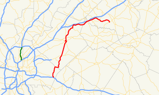
State Route 124 (SR 124) is a 51.1-mile-long (82.2 km) state highway that runs southwest-to-northeast through portions of DeKalb, Gwinnett, Barrow, and Jackson counties in the north-central part of the U.S. state of Georgia.

Georgia State Route 376 highway in Georgia

State Route 376 (SR 376) is a 16.0-mile-long (25.7 km) east–west state highway that travels within portions of Lowndes and Echols counties in the southern part of the U.S. state of Georgia. It connects Clyattville with the Statenville area, via Lake Park. The roadway was built in the late 1950s and designated as SR 376 in 1972.

Georgia State Route 378 highway in Georgia

State Route 378 (SR 378) is a 6.4-mile-long (10.3 km), four-lane state highway that travels west-to-east entirely within Gwinnett County in the north-central part of the U.S. state of Georgia. The route is heavily commercialized with numerous office and industrial parks. It is known along its entire length as Beaver Ruin Road. The roadway was built in the mid-1960s and designated a decade later.

Georgia State Route 380 highway in Georgia

State Route 380 (SR 380) is a 5.8-mile-long (9.3 km) state highway that travels west-to-east in a southern arc entirely within Jasper County in the central part of the U.S. state of Georgia. The highway acts as a partial bypass of Monticello.

Georgia State Route 309 highway in Georgia

State Route 309 (SR 309) is a north-south state highway located in the southwestern part of the U.S. state of Georgia. It exists entirely within Decatur County.

Georgia State Route 308 highway in Georgia

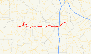
State Route 308 (SR 308) is a northwest-southeast state highway located in the southwest part of the U.S. state of Georgia. Its route is entirely within Sumter County.

Georgia State Route 37 highway in Georgia

State Route 37 (SR 37) is a 153.6-mile-long (247.2 km) state highway that travels west-to-east through portions of Clay, Calhoun, Baker, Mitchell, Colquitt, Cook, Berrien, Lanier, and Clinch counties in the southwestern and south-central parts of the U.S. state of Georgia. The highway connects the Alabama state line west of Fort Gaines to the Homerville area, via Newton, Camilla, Moultrie, Adel, and Lakeland.

Georgia State Route 288 highway in Georgia

State Route 288 (SR 288) is a northwest-southeast state highway located in the northeast part of the U.S. state of Georgia. Its route is entirely within Towns County.

Georgia State Route 272 highway in Georgia

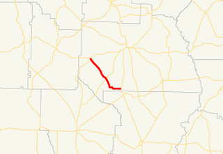
State Route 272 (SR 272) is a 15.4-mile-long (24.8 km) north–south state highway located in the east-central part of the U.S. state of Georgia. Its path is entirely within Washington County.

Georgia State Route 270 highway in Georgia

State Route 270 (SR 270) is a 12.7-mile-long (20.4 km) east–west state highway located in the southern part of the U.S. state of Georgia. Its route is within Mitchell and Colquitt counties.

Georgia State Route 266 highway in Georgia

State Route 266 (SR 266) is a 18.2-mile-long (29.3 km) east–west state highway located in the southwestern part of the U.S. state of Georgia. Its path is within Clay and Randolph counties.

Georgia State Route 262 highway in Georgia

State Route 262 (SR 262) is a 44.4-mile-long (71.5 km) L-shaped state highway located in the southwestern part of the U.S. state of Georgia. It travels within portions of within Decatur and Mitchell counties, and skims the border of Grady County.

Georgia State Route 242 highway in Georgia

State Route 242 (SR 242) is a 25.0-mile-long (40.2 km) east–west state highway located in the central part of the U.S. state of Georgia. It travels through portions of Washington and Jefferson counties.

Georgia State Route 241 highway in Georgia

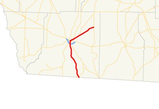
State Route 241 (SR 241) is a 5.6-mile-long (9.0 km) southwest-northeast state highway located in the southwestern part of the U.S. state of Georgia. It exists entirely within Decatur County.

Georgia State Route 83 highway in Georgia

State Route 83 (SR 83) is an 86.5-mile-long (139.2 km) state highway that runs southwest to northeast, with a southeast–to–northwest section, within portions of Monroe, Jasper, Morgan, and Walton counties in the central part of the U.S. state of Georgia. It connects Forsyth, Monticello, and Madison. The portion from the southwestern city limits of Monticello to the Jasper–Morgan county line is included in the Monticello Crossroads Scenic Byway.

Georgia State Route 62 highway in Georgia

State Route 62 (SR 62) is a 62.1-mile-long (99.9 km) state highway in the southwestern part of the U.S. state of Georgia. It connects Columbia, Alabama with Albany.

Georgia State Route 102 highway in Georgia

State Route 102 (SR 102) is a 32.0-mile-long (51.5 km) state highway in the east-central part of the U.S. state of Georgia. The highway travels from Warthen northeast through Mitchell, east through Gibson, southeast to Avera, and arcing east to Wrens.

Georgia State Route 127 highway in Georgia

State Route 127 (SR 127) is a 65.6-mile-long (105.6 km) state highway that runs west-to-east through portions of Marion, Taylor, Macon, and Houston counties in the west-central and central parts of the U.S. state of Georgia. It connects the north-central part of Marion County with the Perry–Warner Robins area.

Georgia State Route 126 highway in Georgia

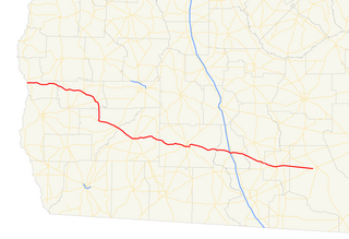
State Route 126 (SR 126) is a 54.9-mile-long (88.4 km) state highway that runs northwest-to-southeast through portions of Bleckley, Dodge, Laurens, and Wheeler counties in the central part of the U.S. state of Georgia.

References

  1. 1 2 Google (July 28, 2013). "Route of SR 65" (Map). Google Maps . Google. Retrieved July 28, 2013.
  2. "National Highway System: Georgia" (PDF). United States Department of Transportation. October 1, 2012. Retrieved July 28, 2013.

Route map: Google

KML file (edithelp)
KML is not from Wikidata