Gerasa (Judaea)

Last updated

Gerasa (Judaea) was an ancient Jewish town mentioned by the historian Josephus ( The Jewish War , 4.9.1) as being sacked by the Imperial Roman army under Lucius Annius during the First Jewish-Roman War.

Contents

Background and early history

In the beginning of the First Jewish-Roman War, around 66 CE, a place called Gerasa (Hebrew : גרש) (Ǧeraš), which, according to Josephus, is also the name of the hometown of Simon bar Kokhba, was overrun by the troops of Vespasian, under the command of Lucius Annius, who after taking the town, slew of its able-bodied men and took captive their wives and children. Afterwards, the Roman soldiers with their auxiliaries proceeded to set fire to their houses and to the houses in the adjoining villages, until war had engulfed the entire hill country. Josephus does not specify its location, but later authors, like Jacob N. Simchoni (1884-1926) (q.v. in Hebrew), has specified that it was in Judaea. [1]

Identification

Several attempts have been made to identify the Gerasa of Judea, the vast majority of scholars concurring that the ancient site is not to be confused with Gerasa (Jarash) of Transjordan, but with a site in Judea proper. [2]

Khirbet Jurish (Judea)

( 31°42′56″N35°05′01″E / 31.715549°N 35.083730°E / 31.715549; 35.083730 (Khirbet Jurish) )

Khirbet Jurish Rock-carved tomb at Kh. Jurish (ruin).jpg
Khirbet Jurish

Khirbet Jurish is the most recent contender for the 1st-century town of Gerasa mentioned by Josephus. Archaeologists Boaz Zissu and Ze'ev Safrai who have studied the various options have both concluded that the site is to be identified with Khirbet Jurish which once stood along the ancient Roman road from Jerusalem to Beit Gubrin, and which is now protected by the Israel Nature and Parks Authority. [3] The ruins of the site presently stand on a hill to the west of Tzur Hadassa, on Har Kitron.

The site, surveyed by archaeologist Boaz Zissu on behalf of the Israel Antiquities Authority, covers an area of about 40 dunams (9.8 acres) and sits at an elevation of 751 metres (2,464 ft) above sea-level. The ruin lay adjacent to the old Jerusalem-Beit Gubrin Roman road, and was visited by PEF explorers, Conder and Kitchener. [4] Three or four ritual immersion baths ( miqva'ot ) have been discovered on the site, attesting to it being an ancient Jewish settlement. The site also contains a large bottle-shaped cistern, with a depth of about 6 meters, and a bottom measuring 4.3 x 4.7 meters. Potsherds found on the site have been dated back to the Hellenistic, early Roman, and Byzantine periods. [5] On the western slope of the ruin are five rock-carved sepulchres, attesting to the site's antiquity.

Jarash Judea

Cave in Jarash, Jerusalem Cave - 3.jpg
Cave in Jarash, Jerusalem

( 31°43′47″N35°00′58″E / 31.729722°N 35.016111°E / 31.729722; 35.016111 (Jarash, Jerusalem) )

Jarash, a former Palestinian village situated 3.5 km. south of Hartuv, was suggested by Isaiah Press as meeting the description of Josephus' Gerasa in Judea. [6] It appears to have been a farmstead during the Second Temple period. Even so, the area is notably smaller than the previously mentioned site.

Gezer

( 31°51′32″N34°55′08″E / 31.859°N 34.919°E / 31.859; 34.919 (Gezer) )

Jacob N. Simchoni noted how others (Schlatter, 1913: 39; Nestle, 90) had suggested that an error may have befallen the copyist of the Josephus manuscript and that Gerasa should perhaps be read as Gezer. [7] This view was also adopted by author, M.L. Fischer. [8] Safrai and Klein, however, reject this opinion, saying that this was highly unlikely, since Gezer had already been subdued prior to the capture of Gerasa (ibid. 4.9.1), and that a Roman camp was stationed in Emmaus (near Gezer). [9]

Places outside of Judaea proper

Jurish (Samaria)

( 32°06′09″N35°19′20″E / 32.1025°N 35.322222°E / 32.1025; 35.322222 (Jurish) )

Jurish was long thought to be the birthplace of Simon Bar-Giora, and the Jewish stronghold taken by the Romans under Lucius Annius, during Vespasian's military campaign to encircle Jerusalem and to make the people's escape into other regions more difficult. Those who supported this view were Shalem (1940), [10] Avi-Yonah (1976), [11] Yoram Tsafrir and co-editors (1994), [12] and Israel Finkelstein (1997), [13] among others. Safrai (1980/81) and Zissu (2007) have argued, from the sequence of events, that the toparchy of Akrabat (Acrabatenne) and the region adjoining thereto (i.e. Jurish of Samaria) were subdued by the Romans about one year after Vespasian's forces completed the encirclement of Jerusalem and had erected citadels in Jericho and in Adida, and had destroyed Gerasa in Judea, based on the timeline of these events in Josephus, The Jewish War 4:487 and 4:550–551. [14]

Jerash (Decapolis)

( 32°16′20″N35°53′29″E / 32.272281°N 35.891397°E / 32.272281; 35.891397 (Jerash) )

The site Jerash in Transjordan (Gerasa) is often mentioned in the writings of Josephus. The recent debate by scholars, however, does not concern those references, but rather one reference in Josephus (The Jewish War 4.9.1) and where this Gerasa was thought to be of strategic importance, and that its capture deemed necessary by the Romans to quell the revolt in Jerusalem. Josephus' reference to this Gerasa has intrigued many scholars. H. St. J. Thackeray, translator and editor of Josephus' The Jewish War (4.9.1), and John Kitto, [15] have both thought that this Gerasa is none other than the site Jerash in Transjordan. [16]

Colonnades in Jerash of Transjordan Jerash - colonnaded street.JPG
Colonnades in Jerash of Transjordan

Historical geographers have argued against Thackeray's view, claiming that Jerash in Transjordan was a Greek city on the side of the Romans, and even if the Jews had taken possession of Gerasa and expelled the Greeks, it leaves unexplained why Annius destroyed the city and also devastated the surrounding area - in the area of the Decapolis which was hardly Jewish; in fact, the excavations there have revealed no destruction at the time of the Jewish uprising. [17] Samuel Klein takes the argument further, writing "Gerasa. The Jewish War 4.9.1. They have already made it known, quite consummately, that it is impossible to say that his intention here is to the city Gerasa which is in Transjordan. For this reason, some have sought to make different emendations [to the original text]: such as by changing the word to read 'Gazara', that is to say, 'Gezer,' etc. However, these same people who assay to 'correct' the text do not ask themselves what need was there for them (i.e. the Roman army) to capture Gezer in the Shefelah in order to shut-off Jerusalem from all sides? Hadn't they already captured the mountain passes, with Emmaus in the West!?" [18]

See also

Related Research Articles

<span class="mw-page-title-main">Jerash</span> City in Jerash Governorate, Jordan

Jerash is a city in northern Jordan. The city is the administrative center of the Jerash Governorate, and has a population of 50,745 as of 2015. It is located 48 kilometres (30 mi) north of the capital city Amman.

<span class="mw-page-title-main">Bar Kokhba revolt</span> Jewish rebellion against Roman rule (132–136 CE)

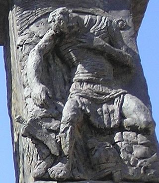
The Bar Kokhba revolt was a large-scale armed rebellion initiated by the Jews of Judea, led by Simon bar Kokhba, against the Roman Empire in 132 CE. Lasting until 136, it was the third and final escalation of the Jewish–Roman wars. Like the First Jewish–Roman War and the Second Jewish–Roman War, the Bar Kokhba revolt resulted in a total Jewish defeat; Bar Kokhba himself was killed by Roman troops at Betar in 135 and the Jewish rebels who remained after his death were all killed or enslaved within the next year.

<span class="mw-page-title-main">Judaea (Roman province)</span> Province of the Roman Empire (6–135 CE)

Judaea was a Roman province from 6 to 132 CE, which incorporated the Levantine regions of Judea, Samaria and Idumea, extending over parts of the former regions of the Hasmonean and Herodian kingdoms of Judea. The name Judaea was derived from the Iron Age Kingdom of Judah.

<span class="mw-page-title-main">Perea</span> Portion of the Herodian kingdom

Perea or Peraea was the term used mainly during the Early Roman period for part of ancient Trans-Jordan, broadly east of Judaea. This region was situated on the eastern side of the Jordan River valley, from a point about one third the way down the lower Jordan River, to a point about one third down the eastern shore of the Dead Sea; it did not extend very far to the east. It was part of the kingdom of Herod the Great and his descendants, and later of subsequent Roman provinces that included former Judea.

Simon bar Giora was the leader of one of the major Judean rebel factions during the First Jewish–Roman War in 1st-century Roman Judea, who vied for control of the Jewish polity while attempting to expel the Roman army, but incited a bitter internecine war in the process.

<span class="mw-page-title-main">Jarash, Jerusalem</span> Place in Jerusalem, Mandatory Palestine

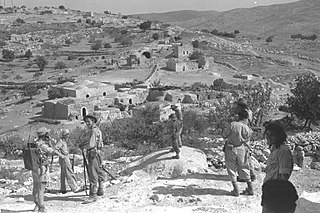
Jarash was a Palestinian village that was depopulated over the course of 1948 Arab-Israeli war. Located 25 kilometers west of Jerusalem, Jarash was a wholly Arab village of 220 inhabitants in 1948. The village was built of stone houses on the spur of a hill, 411 metres (1,348 ft) above sea-level, and lay about 1 km. eastward of the traffic circle opposite Moshav Zanoah, on regional road 3855 that bypasses Beit Shemesh to its east, and which road runs in a northerly-southerly direction along Wadi en Najil. The immediate region to the west of the site of Jarash, upon two hills separated by a valley, grew orchards belonging to the village inhabitants consisting of carobs, figs, almonds and olives. Cave dwellings dot the landscape of this region.

<span class="mw-page-title-main">Arraba, Israel</span> City in Israel

Arraba, also known as 'Arrabat al-Battuf, is an Arab city in Israel. It is located in the Lower Galilee in the Northern District, within Sakhnin valley, adjacent to Sakhnin and Deir Hanna, and climbing a bit on Yodfat range to its south, while also owning some lands south of that in the Beit Netofa Valley to the north of Nazareth area. Arraba attained local council status in 1965, and city status in 2016. In 2021, its population was 26,641.

<span class="mw-page-title-main">Jurish</span> Municipality type D in Nablus, State of Palestine

Jurish is a Palestinian town in the Nablus Governorate in northern West Bank, located 27 kilometers Southeast of Nablus. According to the Palestinian Central Bureau of Statistics (PCBS), the town had a population of 1,541 inhabitants in 2017.

<span class="mw-page-title-main">Second Temple period</span> Period in Jewish history, c. 516 BCE–70 CE

The Second Temple period or post-exilic period in Jewish history denotes the approximately 600 years during which the Second Temple stood in the city of Jerusalem. It began with the return to Zion and subsequent reconstruction of the Temple in Jerusalem, and ended with the First Jewish–Roman War and the Roman siege of Jerusalem.

<span class="mw-page-title-main">Judea</span> Region in the Levant

Judea or Judaea is a mountainous region of the Levant. Traditionally dominated by the city of Jerusalem, it is now part of Palestine and Israel. The name's usage is historic, having been used in antiquity and still into the present day; it originates from Yehudah, a Hebrew name. Yehudah was a son of Jacob, who was later given the name "Israel" and whose sons collectively headed the Twelve Tribes of Israel. Yehudah's progeny among the Israelites formed the Tribe of Judah, with whom the Kingdom of Judah is associated. Related nomenclature continued to be used under the rule of the Babylonians, the Persians, the Greeks, and the Romans. Under the Hasmoneans, the Herodians, and the Romans, the term was applied to an area larger than the historical region of Judea. In 132 CE, the Roman province of Judaea was merged with Galilee to form the enlarged province of Syria Palaestina.

<span class="mw-page-title-main">Bayt Nattif</span> Depopulated Palestinian town in Israel

Bayt Nattif or Beit Nattif was a Palestinian Arab village, located some 20 kilometers southwest of Jerusalem, midway on the ancient Roman road between Beit Guvrin and Jerusalem, and 21 km northwest of Hebron. The village lay nestled on a hilltop, surrounded by olive groves and almonds, with woodlands of oak and carobs overlooking Wadi es-Sunt to its south. It contained several shrines, including a notable one dedicated to al-Shaykh Ibrahim. Roughly a dozen khirbas lay in the vicinity.
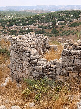
Beth-Anath was mentioned in the Bible as "one of the fenced cities that fell to the lot of Naphtali, and from which the Canaanites were not driven out ."

<span class="mw-page-title-main">Horvat 'Ethri</span> Archeological site in Israel

Horvat 'Ethri, Hebrew for "Ethri ruin", Arabic name: Umm Suweid, is an archaeological site situated in the Judean Lowlands in modern-day Israel. Excavations at the site uncovered the remains of a now partially restored Jewish village of the Second Temple period, wherein are preserved an ancient synagogue, wine presses, cisterns, ritual baths and stone ossuaries, as well as an underground hideout system. The village was violently destroyed during the Bar Kokhba revolt.

<span class="mw-page-title-main">Wadi al-Far'a (river)</span> River in Palestine

Wadi al-Far'a or Tirzah Stream is a stream in the northern West Bank that empties into the Jordan River south of Damia Bridge. It is the largest stream in the West Bank. Wadi al-Far'a is located in the rugged area of the West Bank and cuts east through the Jordan Valley, passing through the Palestinian village of Wadi al-Far'a. The Tirzah Reservoir is used to collect the floodwater of Wadi al-Far'a before it flows into the Jordan River.

<span class="mw-page-title-main">Chezib of Judah</span> Canaanite - Israelite town of Judah

Chezib, also known as Achzib of Judah, is a biblical place-name associated with the birth of Judah's son, Shelah (Genesis 38:5), corresponding to the Achzib of the Book of Joshua (15:44), a town located in the low-lying hills of the plain of Judah, known as the Shefela. In I Chronicles 4:22, the town is rendered as Chozeba. The place is now a ruin.

<span class="mw-page-title-main">Rebbo</span>

Rebbo or Horvat Rebbo, alternative spellings: Robbo, Ribbo; in Arabic Khurbet Rubba, is an ancient site in Israel, mentioned by Eusebius in his Onomasticon as possibly referring to a site by a similar name in the Book of Joshua. The site, which is now a ruin, sits on a hill 414 metres (1,358 ft) above sea level, in the Shephelah region, and is now part of the Adullam-France Park, maintained by the Jewish National Fund (KKL). It lies about 1.5 km. to the west of Aderet as the crow flies, and about 11 kilometres (7 mi) northeast of Beit Guvrin National Park.

<span class="mw-page-title-main">Khirbet Jurish</span> Archaeological ruin southeast of Jerusalem

Khirbet Jurish is an archaeological ruin 30 kilometres (19 mi) southwest of Jerusalem. The site is protected by the Israel Nature and Parks Authority. The ruins of the site stand on a hill to the west of Tzur Hadassa, on a mountain now called Har Kitron, along regional highway 375.

Garis ,(Greek: Γαρεις; Γάρις), alternative spellings Garsis; Garisme, was a Jewish village in Lower Galilee, situated ca. 4 km. from Sepphoris. The village, although now a ruin, features prominently in the writings of Josephus, where it served temporarily as the place of residence for Josephus during the First Jewish Revolt. In the early stages of the war, Josephus, with the Galileans who were put under his command, cast up a bank around the village, in anticipation of a Roman assault upon the town.

And indeed this sight of the general (Vespasian) brought many to repent at their revolt, and put them all into a consternation; for those that were in Josephus's camp, which was at the city called Garis, not far from Sepphoris, when they heard that the war was come near them, and that the Romans would suddenly fight them hand to hand, dispersed themselves and fled....
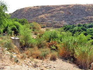
<span class="mw-page-title-main">Umm er Rus</span> Ancient ruin in the Judean mountains

Umm er Rus, alternate spelling Um Ra'us, is a Roman-Byzantine era ruin that sits high on a spur in the Judean mountains, overlooking the Elah valley. The site was formerly known in Arabic as Umm er Rûs esh-Shamālīya, to distinguish it from another site by the same name, lying on an adjacent hill to its south. The site takes its Arabic name from the prospect that it affords, having the broad connotation of "the place with the hill-top." Its older Hebrew appellation is no longer known. The ruin is located a little less than 1 mile northeast of Aviezer.

The Synagogue-Church at Gerasa in northwestern Jordan was originally an ancient Byzantine era synagogue that was later converted to a church. It is located within the Decapolis Gerasa and is situated on high ground that overlooks the Temple of Artemis at Gerasa. The synagogue is evidence of Jewish settlement in the Transjordan through late antiquity.

References

  1. Simchoni, (1968), p. 545, s.v. גרש(b) [reprint of 1923 edition], where he cites Josephus ( The Jewish War 4.9.1) and where he makes a distinction between Gerasa (Greek : Γέρασα) of Judea and Gerasa of Transjordan.
  2. Klein (1939), p. 106; Shalem (1940), p. 172
  3. Archaeologist Ze'ev Safrai, at first, placed the Gerasa of Josephus (Wars 4.9.1) in Samaria, like his predecessors (Safrai, 1980, p. 54 [note 16]), but later that same year he came to a different conclusion, saying that it is to be recognised in the Kh. Jurish (near Tzur Hadassa), just as it was concluded by Boaz Zissu (Safrai, 1980/81, p. 327).
  4. Conder & Kitchener (1883), p. 116
  5. Zissu (2007), p. 221
  6. Press (1951), p. 174
  7. Simchoni (1968), p. 545, s.v. גרש(b) [reprint of 1923 edition]
  8. Fischer et al., 1996, pp. 162–163
  9. Safrai (1980/81), p. 372; Klein (1939), p. 106
  10. Shalem (1940), p. 172
  11. Avi-Yonah (1976), pp. 61, 109
  12. Tsafrir (1994), p. 133
  13. Finkelstein (1997), p. 759
  14. Zissu (2007), p. 220; Safrai (1980/81), p. 327
  15. Kitto, 1845, vol 1, p. 755, who writes that Jerash is the Gerasa of The Jewish War (4.9.1).
  16. Josephus (1957), ed. Thackeray, vol. 3, p. 145 (note c), on The Jewish War 4.9.1 (4.487)
  17. Möller & Schmitt (1976), p. 72
  18. Klein (1939), p. 106

Bibliography