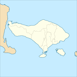
Gerokgak, Buleleng

Last updated
Gerokgak
Village and district
Indonesia Bali location map.svg
Red pog.svg
Gerokgak
Coordinates: 8°11′08″S114°47′27″E / 8.185487879434874°S 114.79096771061646°E / -8.185487879434874; 114.79096771061646
CountryFlag of Indonesia.svg  Indonesia
Province Bali
Regency Buleleng Regency

Gerokgak is a village [1] and a district [2] ( kecamatan ) in the Buleleng Regency, on the north-west coast of Bali, Indonesia.

Contents

Description

The district extends along the north-west coast of Bali, from the westernmost point of the island to Tegallengah (not included). [3] To the south is Jembrana Regency, and to the east is Seririt district in Buleleng Regency.

It includes most of West Bali national park. [4]

Villages

The district counts 14 villages (desa): [2]

Reef conservation and turtle protection in Pemuteran Bay

This project started with Australian Chris Brown, who first came to Permuteran in 1991. [5] The following year he started the Reef Seen Divers’ Resort - which started restoration work on the coral reefs, badly damaged by fishing with poison and explosives. Gathering the local population, friends and diver colleagues around the project, [6] his "Reef Gardeners" showed the local fishermen how to catch crown-of-thorns starfish (over 75,000 crown-of-thorns removed between 1996 and 1998) and horn drupe (Drupella cornus), which also threaten the reefs; and how to repair broken corals, thus saving hundreds of years of coral growth. They also installed structures on the ocean floor to create artificial reefs. [7] In 2005, with funding from AusAid, [8] they began to install statues of Buddha off the coast; this Temple garden soon became an attraction for scuba diving tourists. This success was followed from 2014 on with the undertaking of the Garden of the gods half a kilometer away, [8] another offcoast assemblage of statues at 28 meters deep, [5] [9] complete with split gate and 25 beautifully carved statues sitting beside a damaged coral reef [10] [lower-alpha 1] and covering 2,500 square meters of sandy seabed [5] at a depth from 5 to 30 metres. [13] All this work is tightly linked with the local community. [7]
Meanwhile, Reef Seen also started in 1994 the Turtle Project of Pemuteran, [14] [9] which aims at protecting the wild turtle population. It rewards people who bring in or signal newly-laid sea turtle’s eggs, which encourages villagers not to kill or capture mature turtles who can then return and lay more eggs. Reef Seen's hatchery takes care of the collected eggs and the hatchlings are released at sea when they are big enough to get a fair chance at survival. Different seasons see three different species in the hatchery: Green, Olive Ridley, and Hawksbill. [14] On top of its educational work, over the years its hatchery has allowed the release of several thousands of turtles (juveniles and adults) into the ocean. [6]

A collaboration started in 2000 between the Karang Lestari Foundation (chairman in 2012: I Gusti Agung Prana) and the Global Coral Reef Alliance, leading to the installation of about 70 underwater 'bio-rocks' [15] [9] over half a kilometer. [16] Many awards have been received by the project: [15]

Other reefs nearby

These are only some of the shallows that lay near Pemuteran.

Napoleon Reef

This reef, from 5 to 30 metres deep, has an upper area about the size of half a football field that gently slopes down on each side, and three underwater peninsulas that reach out to deeper levels. [13]

Kebun Chris

Just 20 metres away from the shore in front of Reefs Seen, it was the first reef to benefit from protection, hard work and care and is accordingly rich in diversity. Its depth is from 2 to 15 metres; [13]

Middle Reef

It has suffered severe damage in the early 1990's but has started to recover (after 2010). Its depth goes from 16 to 30 metres. [13]

Temple Wall

This reef sits directly in front of 3 seaside temples, amidst nutrient-rich currents, with depths from 3 to 26 metres. It has received protection from destructive fishing methods since 1995 and has recovered (after 2010). [13]

Notes and references

Notes

  1. The unterwater temple or "Garden of the gods" represents the Dewata Nawa Sanga or "Guardians of the Nine Directions", the nine gods of Bali, placed in an octagonal mandala with Shiva sitting on a turtle in the middle, surrounded by the other 8 gods placed in accordance to their attributed directions of the winds or compass points. There are also dancers, musicians, benches, fountains and lanterns. [11] Pieces of live corals were planted in holes in the statues' bases to help their propagation. [12]

Related Research Articles

<span class="mw-page-title-main">Bali</span> Province and island in Indonesia

Bali is a province of Indonesia and the westernmost of the Lesser Sunda Islands. East of Java and west of Lombok, the province includes the island of Bali and a few smaller offshore islands, notably Nusa Penida, Nusa Lembongan, and Nusa Ceningan to the southeast. The provincial capital, Denpasar, is the most populous city in the Lesser Sunda Islands and the second-largest, after Makassar, in Eastern Indonesia. The upland town of Ubud in Greater Denpasar is considered Bali's cultural centre. The province is Indonesia's main tourist destination, with a significant rise in tourism since the 1980s, and becoming an Indonesian area of overtourism. Tourism-related business makes up 80% of the Bali economy.

<span class="mw-page-title-main">Padangbai</span> Place in Bali, Indonesia

Padangbai is a small coastal town in the Karangasem Regency, in south-eastern Bali, Indonesia. It serves as a ferry port for travel to Lembar on Lombok, The Gilis and other Lesser Sunda Islands.

<span class="mw-page-title-main">Nusa Dua</span> Resort area in Bali, Indonesia

Nusa Dua is a resort area built in the 1970s in the southern part of Bali, Indonesia. Known as an enclave of large five-star resorts, it covers 350 hectares of land and encloses more than 20 resorts. It is located 22 kilometers from Denpasar, the provincial capital of Bali, and is administered as part of Benoa subdistrict (kelurahan) in South Kuta, Badung Regency. Nusa Dua means two islands, because there are two islands in the bay of Bali Tourism Development Corporation area. On the southern side lies Peninsula Island, and on the northern side lies Nusa Dharma Island, which is smaller but shadier, and which contains the Pura/Temple Nusa Dharma.

<span class="mw-page-title-main">Bangli Regency</span> Regency in Bali, Indonesia

Bangli Regency is the one and only landlocked regency (kabupaten) of Bali, Indonesia.

<span class="mw-page-title-main">Buleleng Regency</span> Regency in Bali, Indonesia

Buleleng is a regency of Bali Province, Indonesia. It stretches along the north side of the island of Bali from the Bali Strait in the west almost to the eastern end of the island. It has an area of 1,365.88 km2 and a population of 624,125 at the 2010 census and 791,910 at the 2020 census; the official estimate as of mid-2022 was 825,141. Its regency seat is in the town of Singaraja.

Tulamben is a small fishing village on the north-east coast of Bali. It is among the most popular dive sites on Bali since the wreck of the Liberty, a US Army Transport ship torpedoed by a Japanese submarine in 1942 lies just off shore. During high-season, up to 100 divers descend to the wreck each day.

<span class="mw-page-title-main">West Bali National Park</span>

West Bali National Park is a national park located in Buleleng Regency and Jembrana Regency, on the west point of Bali, Indonesia. The park covers around 190 square kilometres (73 sq mi), some 82% of which is on land and the remainder at sea. This is approximately 3% of Bali's total land area.

<span class="mw-page-title-main">Sanur, Bali</span> Place in Bali, Indonesia

Sanur is a coastal stretch of beach east of Denpasar in southeast Bali, which has grown into a little town in its own right. A 5.1 km (3.2 mi) area of Sanur's coastline, from Matahari Terbit Beach to Mertasari Beach, was reclaimed in 2008.

<span class="mw-page-title-main">Candi Dasa</span> Place in Bali, Indonesia

Candi Dasa, or often Candidasa is a seaside town on the eastern cost of Bali that rests on the edge of a fresh water lagoon, named Candi Dasa Lagoon. The town is centred around Jalan Raya Candida, where a number of hotels, restaurants, and shops line the main road. It is popular tourist stop, attracting divers and those looking for a more sedate alternative to the busy, nightclub filled Kuta area or the large, manicured resorts at Nusa Dua.

<span class="mw-page-title-main">Lovina Beach</span> Place in Bali, Indonesia

Lovina Beach is a beach on the northwestern side of the island of Bali, Indonesia.

<span class="mw-page-title-main">Bedugul</span> Place in Bali, Indonesia

Bedugul is a mountain lake resort area in Bali, Indonesia, located in the centre-north region of the island near Lake Bratan on the road between Denpasar and Singaraja. The area covers the villages of Bedugul itself, Candikuning, Pancasari, Pacung and Wanagiri amongst others.

<span class="mw-page-title-main">Nusa Lembongan</span> Island in Klungkung Regency, Indonesia

Nusa Lembongan is an island located southeast of Bali, Indonesia. It is part of a group of three islands that make up the Nusa Penida district, of which it is the most famous of the three islands of Nusa Penida, Nusa Lembongan, and Nusa Ceningan - known together as the "Nusa Islands". This island group, in turn, is part of the Lesser Sunda Islands.

<span class="mw-page-title-main">Banjar, Buleleng</span>

Banjar is a district (kecamatan) in the regency of Buleleng in northern Bali, Indonesia.

<span class="mw-page-title-main">Tejakula, Buleleng</span> District in Buleleng Regency, Bali Province, Indonesia

Tejakula is a district (kecamatan) in the regency of Buleleng in northern Bali, Indonesia. It stands on the north-east coast of the island. Along the coastal road are the villages of Bangkah, Pacung, Julah, Bondalem, Desa Tejakula, Les, Penuktukan, Sambirenteng and Tembok. Other villages are Sambiran and Madenan.

<span class="mw-page-title-main">Balinese temple</span> Balinese Hindu temple

A Pura is a Balinese Hindu temple and the place of worship for adherents of Balinese Hinduism in Indonesia. Puras are built following rules, style, guidance, and rituals found in Balinese architecture. Most puras are found on the island of Bali, where Hinduism is the predominant religion; however many puras exist in other parts of Indonesia where significant numbers of Balinese people reside. Mother Temple of Besakih is the most important, largest, and holiest temple in Bali. Many Puras have been built in Bali, leading it to be titled "the Island of a Thousand Puras".

<span class="mw-page-title-main">Jembrana Regency</span> Regency in Bali, Indonesia

Jembrana Regency is a regency (kabupaten) in the southwest of Bali, Indonesia. It has an area of 841.8 km2 and had a population of 261,638 at the 2010 Census and 317,064 at the 2020 Census; the official estimate as at mid 2022 was 327,850. Its regency seat is the town of Negara.

<span class="mw-page-title-main">Amed (Bali)</span> Group of fishing villages in Karangasem Regency on the north coast of Bali

Amed is a village on the east coast in Abang District, Karangasem Regency, Bali, Indonesia. In the wake of heavy tourism development, actors in the tourism industry use the village's name to designate a 14-km stretch of coast that includes several other villages, namely from west to east: Amed, Jemeluk, Bunutan, Lipah, Lehan, Selang, Banyuning, Aas and Kusambi. A more correct geographical name would be the north coast of the Seraya peninsula, or North Seraya.

Buleleng is a district in Buleleng Regency, Bali, Indonesia. Its capital is Singaraja.

<span class="mw-page-title-main">Pura Taman Ayun</span> Balinese Hindu temple in Indonesia

Pura Taman Ayun is a compound of Balinese temple and garden located in Mengwi district (kecamatan) in Badung Regency, Bali, Indonesia. Its water features are an integral part of the local subak system.

References

  1. "Gerokgak, village". m.nomor.net. Retrieved 2024-06-04.
  2. 1 2 3 "Gerokgak, district". m.nomor.net. Retrieved 2024-06-04.
  3. "Gerokgak district, map". google.com/maps.
  4. "West Bali national park, contours on map". openstreetmap.org.
  5. 1 2 3 Verrips, Jojada (2015). "Religion under Water" (PDF). Etnofoor, The Sea. 27 (1): 75–88. Retrieved 2024-05-13. See p. 81.
  6. 1 2 Kumar, Vinay (August 31, 2023). "Ep 121: Chris Brown, the Sustainability Warrior of Pemuteran, Bali". buzzsprout.com. Retrieved 2024-05-13.
  7. 1 2 "Reef Gardeners of Pemuteran". reefseenbali.com. Retrieved 2024-05-13.
  8. 1 2 Reef Seen, video, 2'20.
  9. 1 2 3 "Temple Reef, Biorock Permuteran and Turtle Hatchery Project - map". google.fr/maps.
  10. Reef Seen, video, 2'08.
  11. Reef Seen, video, 1'17.
  12. Reef Seen, video, 9'10.
  13. 1 2 3 4 5 "Pemuteran Bay". reefseenbali.com. Retrieved 2024-05-13.
  14. 1 2 Brown, Chris. "Bali Turtle Hatchery. Project Penyu – The Turtle Project". reefseenbali.com. Retrieved 2024-05-13.
  15. 1 2 "Pemuteran coral restoration wins awards". June 27, 2012. Archived from the original on 2012-06-30.
  16. "Pemuteran Bay Coral Protection Foundation" (PDF). equatorinitiative.org. p. 5. Retrieved 2024-05-13.