
Merseburg is a town in central Germany in southern Saxony-Anhalt, situated on the river Saale, and approximately 14 km south of Halle (Saale) and 30 km west of Leipzig. It is the capital of the Saalekreis district. It had a diocese founded by Archbishop Adalbert of Magdeburg. The University of Merseburg is located within the town. Merseburg has around 35,000 inhabitants.

Busto Arsizio is a comune (municipality) in the south-easternmost part of the province of Varese, in the Italian region of Lombardy, 35 kilometres (22 mi) north of Milan. The economy of Busto Arsizio is mainly based on industry and commerce. It is the fifth municipality in the region by population and the first in the province.

Sangerhausen is a town in Saxony-Anhalt, central Germany, capital of the district of Mansfeld-Südharz. It is situated southeast of the Harz, approx. 35 kilometres east of Nordhausen, and 50 km (31 mi) west of Halle (Saale). About 26,000 people live in Sangerhausen (2020).

Aspley Guise is a village and civil parish in the west of Central Bedfordshire, England. In addition to the village of Aspley Guise itself, the civil parish also includes part of the town of Woburn Sands, the rest of which is in the City of Milton Keynes in Buckinghamshire. Together with Woburn Sands and Aspley Heath, it forms part of the Milton Keynes urban area. It is centred 6 miles (9.7 km) east southeast of Central Milton Keynes and 1 mile (1.6 km) south of the M1 junction 13. It has its own railway station on the Marston Vale Line, and an historic centre with 29 listed buildings.
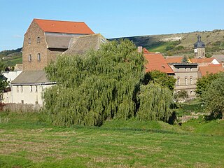
is a town in the Saalekreis district, Saxony-Anhalt, Germany.

Klöden is a village and a former municipality in Wittenberg district in Saxony-Anhalt, Germany. Since 1 January 2011, it is part of the town Jessen (Elster).

Memleben Abbey was a Benedictine monastery in Memleben on the Unstrut river, today part of the Kaiserpfalz municipality in Saxony-Anhalt, Germany. The convent, now ruined, was established by Emperor Otto II and his consort Theophanu about 979.
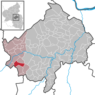
Heimweiler is an Ortsgemeinde – a municipality belonging to a Verbandsgemeinde, a kind of collective municipality – in the Bad Kreuznach district in Rhineland-Palatinate, Germany. It belongs to the Verbandsgemeinde Kirner Land, whose seat is in the town of Kirn.
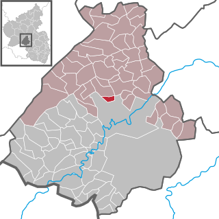
Vollmersbach is an Ortsgemeinde – a municipality belonging to a Verbandsgemeinde, a kind of collective municipality – in the Birkenfeld district in Rhineland-Palatinate, Germany. It belongs to the Verbandsgemeinde Herrstein-Rhaunen, whose seat is in Herrstein.
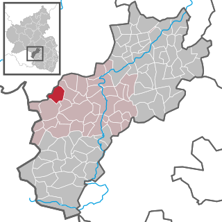
Hausweiler is an Ortsgemeinde – a municipality belonging to a Verbandsgemeinde, a kind of collective municipality – in the Kusel district in Rhineland-Palatinate, Germany. It belongs to the Verbandsgemeinde Lauterecken-Wolfstein.
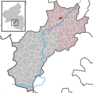
Thallichtenberg is an Ortsgemeinde – a municipality belonging to a Verbandsgemeinde, a kind of collective municipality – in the Kusel district in Rhineland-Palatinate, Germany. It belongs to the Verbandsgemeinde of Kusel-Altenglan, whose seat is in Kusel.
Wangen is a village and a former municipality in the Burgenlandkreis district, in Saxony-Anhalt, Germany. Since 1 July 2009, it is part of the town Nebra.
Karsdorf is a municipality in the Burgenlandkreis district, in Saxony-Anhalt, Germany.

Stedten is a village and a former municipality in the Mansfeld-Südharz district, Saxony-Anhalt, Germany.

Esperstedt is a village and a former municipality in the Saalekreis district, Saxony-Anhalt, Germany. Since 1 January 2010, it is part of the municipality Obhausen.

Banloc is a commune in Timiș County, Romania. It is composed of four villages: Banloc, Ofsenița, Partoș and Soca.

The Hassegau was a medieval shire (Gau) in the Eastphalia region of the Duchy of Saxony. It was located in the duchy's southeastern corner; confined by the Saale river to the east and its Unstrut and Wipper tributaries to the south and north. Its most important town was Merseburg. In present-day borders, it is in the southeastern part of Saxony-Anhalt.

Geisel is a river of Saxony-Anhalt, Germany. The source of the Geisel, the Geiselquell, is located in the village of Sankt Micheln just west of Mücheln. The Geisel flows east through Geiseltal, or Geisel valley, until it flows into the Gotthardteich in Merseburg, thats runoff, the Klia, empties into the Saale.

The Mosaic of Reḥob, is a late 3rd–6th century CE mosaic discovered in 1973. The mosaic, written in late Mishnaic Hebrew, describes the geography and agricultural rules of the local Jews of the era. It was inlaid in the floor of the foyer or narthex of an ancient synagogue near Tel Rehov, 4.5 kilometres (2.8 mi) south of Beit She'an and about 6.5 kilometres (4.0 mi) west of the Jordan River. The mosaic contains the longest written text yet discovered in any Hebrew mosaic in Israel, and also the oldest known Talmudic text.
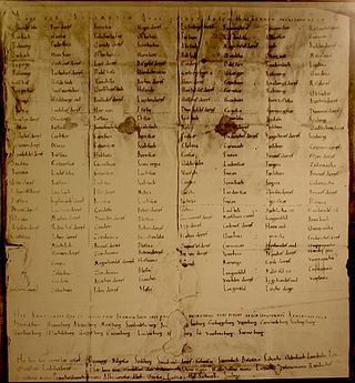
The Hersfeld Tithe Register is a list of the places and castles in the Friesenfeld Gau (territory) and in Hassegau, from which Hersfeld Abbey received tithes. The original document dates from between 881 and 887 or between 896 and 899, but no longer exists. The list is found in a transcript from the 11th Century, which is now in the Hessischen Staatsarchiv Marburg.


