The Battle of Rossbach took place on 5 November 1757 during the Third Silesian War near the village of Rossbach (Roßbach), in the Electorate of Saxony. It is sometimes called the Battle of, or at, Reichardtswerben, after a different nearby town. In this 90-minute battle, Frederick the Great, king of Prussia, defeated an Allied army composed of French forces augmented by a contingent of the Reichsarmee of the Holy Roman Empire. The French and Imperial army included 41,110 men, opposing a considerably smaller Prussian force of 22,000. Despite overwhelming odds, Frederick managed to defeat the Imperials and the French.

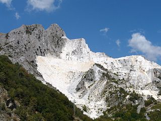
A quarry is a type of open-pit mine in which dimension stone, rock, construction aggregate, riprap, sand, gravel, or slate is excavated from the ground. The operation of quarries is regulated in some jurisdictions to manage their safety risks and reduce their environmental impact.
Waldridge is a village in County Durham, in England. The population at the 2001 Census was 215. Prior to the 2011 Census the parish boundaries changed and the population shown at this census was 4,215. It is situated to the south west of Chester-le-Street. It is known as either Waldridge Fell or Waldridge Village, the 'Fell' referring to the surrounding area of moorland. The village used to be known as Waldridge Colliery. The current village dates back to the 1890s, the original village having been located on the fell which overlooks the present location. Rainwater runs into the Cong Burn to the north and the South Burn to the south, both of which flow into the River Wear which is a few miles to the east.

Tower Colliery was the oldest continuously working deep-coal mine in the United Kingdom, and possibly the world, until its closure in 2008. It was the last mine of its kind to remain in the South Wales Valleys. It was located near the villages of Hirwaun and Rhigos, north of the town of Aberdare in the Cynon Valley of South Wales.

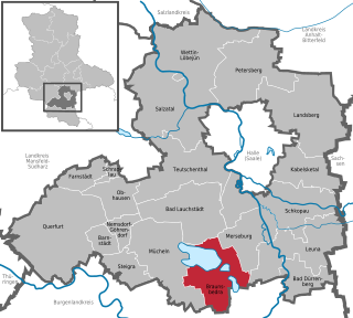
Braunsbedra is a town in the Saalekreis district, in Saxony-Anhalt, Germany. It is situated approximately 11 km southwest of Merseburg.

Borna is a town in Saxony, Germany, capital of the Leipzig district. It is situated approximately 30 km southeast of Leipzig city. It has approx. 19,000 inhabitants. The town is the district seat of the district of Leipzig.
The Frankleben hoard is a significant hoard deposit of the European Bronze Age, associated with the Unstrut group (associated with the Tumulus or early Urnfield culture. The site is in the Geisel valley, formed by a minor tributary of the Saale River. It was discovered in 1946 in a brown coal pit near Frankleben, now a part of Braunsbedra municipality, Saxony-Anhalt, Germany.

Theo Harych was a German writer.

The Kulkwitzer See, colloquially called Kulki, is a lake in the western part of Saxony, Germany. The lake is a part of the Central German Lake District.
Open-pit coal mining in the United Kingdom ended in November 2023.
Sohagpur Coalfield is located in Shahdol district in the Indian state of Madhya Pradesh in the basin of the Son River. It is the biggest coalfield in the state of Madhya Pradesh.

The Leipzig Bay(‹See Tfd›German: Leipziger Tieflandsbucht) or Leipzig Basin or Saxon Lowland or Saxon Bay is a very flat, originally lakeless and highly fertile plain in Central Germany, in northwestern Saxony and southeastern Saxony-Anhalt, anchored by the foothills of the Harz mountains in the northwest and of the Ore Mountains in the southeast.

Teltow is both a geological plateau and also a historical region in the German states of Brandenburg and Berlin. As an historical region, the Teltow was one of the eight territories out of which the March of Brandenburg was formed in the 12th and 13th centuries. As a result of the Teltow War (1239–1245) the question of territorial lordship of the newly created heart of the expanding march was finally decided here. Between 1835 and 1952 there was also a county, Teltow district; in addition a town immediately south of Berlin, in the present-day county of Potsdam-Mittelmark, bears the name Teltow.

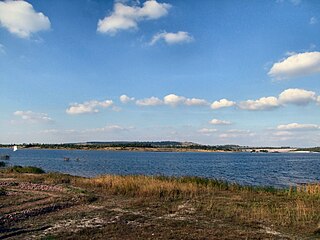
Geiseltalsee, literally Geisel valley lake, is at about 1,840 hectares the largest artificial lake by area in Germany. Once flooding of the Cottbuser Ostsee is complete it will surpass Geiseltalsee in surface area, covering 19 square kilometres (7.3 sq mi). Geiseltalsee lies in the Saalekreis district of the state Saxony-Anhalt. The lake was created in 2003-11 by flooding a former opencast lignite mine in the Geiseltal ; the name of that valley had become widely known due to the notable fossil record which emerged from that coal mine.

The Burnley Coalfield is the most northerly portion of the Lancashire Coalfield. Surrounding Burnley, Nelson, Blackburn and Accrington, it is separated from the larger southern part by an area of Millstone Grit that forms the Rossendale anticline. Occupying a syncline, it stretches from Blackburn past Colne to the Yorkshire border where its eastern flank is the Pennine anticline.

The Meuro mine was a former open-cast mine located in the state of Brandenburg, Germany that was in operation from 1958 to 1999. It was a source of lignite, often referred to as brown coal, which was used in local factories and power stations. It was one of a number of mines in the Lusatia area which left a massive water debt when the water was pumped out for the operation of the mine. This had to be remediated by the company, Lausitzer und Mitteldeutsche Bergbau-Verwaltungsgesellschaft (LMBV), a state-owned company. The area was flooded and converted into a multi-use recreation and tourism area.

The Rheinisches Braunkohlerevier, often called the Rhenish mining area, is a lignite mining area or district in the Cologne Bay, on the northwestern edge of the Rhenish Slate Mountains. The mining of lignite using the open pit method has had a significant impact on the landscape here and led to the formation of several important industrial sites. The area includes the Zülpicher and Jülicher Börde, the Erft lowlands and the Ville, making it the largest lignite mining area in Europe. To a lesser extent clay, silica sand and loess are mined here. The area is the only active lignite mining area in what was West Germany during German partition and contains the mines with the largest surface area, greatest depth, and biggest annual output of coal.

Theodor Otto Gustav Johannes Weigelt was a German paleontological, geologist. After studying at the Martin Luther University Halle-Wittenberg, he habiltated in December 1918 and initially worked as a collections assistant at Halle before he began an academic career at the same university. In 1924, he was commissioned to study the geology of seismic events along the Texas Gulf Coast and discovered that salt domes were important in oil drilling. Weigelt's study of fossil specimens on the gulf coast, led him to become the first proponent of taphonomy, the study of how organisms decay and eventually become fossilised. In 1926, he became a lecturer at University of Greifswald. A year later he published "Recent Vertebrate Corpses and Their Palaeobiological Significance" that cemented his reputation as the founder of biostratinomy the process that occurs after an organism dies and becomes buried. The work led to a promotion as full professor. In 1929, he moved back to Halle to take the position of professor of geology, succeeding his former scientific mentor Johannes Walther. In Halle, he made an extensive study of vertebrate fossils in the Kupferschiefer area and collected many thousands of specimens. In 1933, he became a Nazi. In 1934, he founded the Museum for Earth Science of Central Germany at Martin Luther University Halle-Wittenberg. After the war, he was denazified, fined and was no longer allowed to work.

The Geiseltal fossil deposit is located in the former lignite district of the Geiseltal south of the city of Halle in Saxony-Anhalt, Germany. It is an important site of now extinct plants and animals from the Middle Eocene period 48 to 41 million years ago. There is evidence that coal was first mined in the Geiseltal in 1698, but the first fossils only came to light by chance at the beginning of the 20th century. Scheduled scientific excavations began in 1925 by the Martin Luther University Halle-Wittenberg. Interrupted by World War II, the investigations can be divided into two research phases. Due to the increasing depletion of the raw material deposits, the excavations gradually came to a standstill in the mid-1980s and finally ended at the beginning of the third millennium.


