Sindhis are an Indo-Aryan ethnolinguistic group, originating from and native to Sindh region of Pakistan, who share a common Sindhi culture, history and language. The historical homeland of Sindhis is bordered by the southeastern part of Balochistan, the Bahawalpur region of Punjab and the Kutch region of Gujarat.

The districts of Pakistan are the third-level administrative divisions of Pakistan, below provinces and divisions, but forming the first-tier of local government. In total, there are 166 districts in Pakistan, including the Capital Territory, and the districts of Azad Kashmir and Gilgit-Baltistan. These districts are further divided into tehsils and union councils.

Sukkur is a city in the Pakistani province of Sindh along the western bank of the Indus River, directly across from the historic city of Rohri. Sukkur is the third largest city in Sindh after Karachi and Hyderabad, and 14th largest city of Pakistan by population. The city was originally founded by the Rai dynasty of Sindh. The modern city was built in the 1840s. New Sukkur was established during the British era alongside the village of Sukkur. Sukkur's hill, along with the hill on the river island of Bukkur, form what is sometimes considered the "Gate of Sindh".
Mirpur Khas is a city in Sindh province, Pakistan. The city was built by Talpur rulers of Mankani branch. According to the 2017 Census of Pakistan, its population was 205,913. Mirpur Khas is known for its mango cultivation, with hundreds of varieties of the fruit produced each year - it is also called the “City of Mangoes,” and has been home to an annual mango festival since 1955. After the completion of Hyderabad-Mirpurkhas dual carriage way, the city has become hub of commercial activities.
Korangi is one of the neighbourhoods of Korangi District, Landhi Town in Karachi, Sindh, Pakistan. Korangi District has three administrative towns.

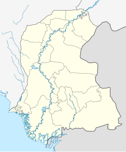
Sanghar District (Sindhi: ضلعو سانگھڙ, Urdu: ضلع سانگھڑ) is one of the largest districts of Sindh province, Pakistan. This district lies between 25058'13 N latitudes and 69024'4E longitudes. It was a village before Mallah tribe were settled there. This district has the largest Mallah population. It has an area of 9874 square kilometres. It is located in the centre of Sindh and is bounded to the east by India. The district capital, Sanghar, is itself a small city roughly 35 miles (56 km) east-south-east of the city of Nawabshah and the same distance north of Mirpur Khas. Its primary industry is agriculture.

Thatta District is located in the southern area, locally called Laar, of the province of Sindh, Pakistan. Its capital is Thatta. It is home to a large necropolis of Makli. In 2013, several talukas were separated to form the new Sujawal District.

The Badin District is a district in the Sindh province of Pakistan. The total area of the district is 6,726 square kilometers. Headquartered at the city of Badin, the district is situated between 24°-5` to 25°-25` north latitude and 68 21’ to 69 20’ east longitude and is bounded on the north by the Tando Allahyar District, Northwest by Hyderabad District, on the east by Mirpur Khas and Tharparkar districts, on the south by the Kutch district of India, and on the west by Sujawal and Tando Muhammad Khan District.
Umerkot District, also known as Amarkot District, is a district in the Sindh province of Pakistan. The city of Umerkot is the capital of the district. Sindhi is the native language of approximately 95.1% of the residents according to the 2023 Pakistani census. Umerkot is the only non-Muslim majority district in Pakistan, with adherents of Hinduism representing 54.6% of the total population as per 2023 Pakistani census. According to 2023 Pakistani census population of Umerkot District is 1,158,284.

Sir Creek, originally Ban Ganga, is a 96 km tidal estuary in the uninhabited marshlands of the Indus River Delta on the border between India and Pakistan. The creek flows into the Arabian Sea and separates Gujarat state in India from Sindh province in Pakistan. The long-standing India-Pakistan Sir Creek border dispute stems from the demarcation "from the mouth of Sir Creek to the top of Sir Creek, and from the top of Sir Creek eastward to a point on the line designated on the Western Terminus". From this point onward, the boundary is unambiguously fixed as defined by the Tribunal Award of 1968.
Wind power is a form of renewable energy in Pakistan which makes up more than 6% of the total electricity production in the country. As of 2018, wind power capacity in Pakistan was 1,287 MW. The government is looking to increase the share of renewable energy and plans to add around 3.5 GW of wind energy capacity by 2018.
The city of Karachi is a major transport hub of Pakistan. The Karachi port and airport are major gateways to Pakistan. The Karachi Railway stations transports the major part of Pakistan's trade with other countries.

The Sindh Police, is a law enforcement agency established in 1843 under a proclamation issued by Sir Charles James Napier, who became the conqueror of the State of Sindh by defeating the forces of the Talpur rulers at the Battle of Miani near Hyderabad on 20 March 1843. Ever since its inception, the organization was raised on the model of the Royal Irish Constabulary to maintain law and order and law enforcement in Sindh, Pakistan. The department serves an area of ~140,914km2 and has about 280,000 police officers and staff. As of 24 March 2024, Ghulam Nabi Memon is the Inspector-General of Police.

Bahria Schools and Colleges were established by the Pakistan Navy (PN) for the education of the children of its officers, sailors, and civilian employees at Karachi, Sindh.
Renewable energy in Pakistan is a relatively underdeveloped sector; however, in recent years, there has been more and more interest to explore renewable energy resources for the energy production. Around 10.57% of Pakistan’s total installed power generation capacity comes renewables. Most of Pakistan's renewable energy comes from hydroelectricity. As per the vision of the Prime Minister, there is the aim to “induct 20% of RE by the year 2025 and 30% of RE by the year 2030.”

Nazimabad District, formerly Karachi Central District, is an administrative district of Karachi Division in Sindh, Pakistan created in 1996. According to 2023 Pakistani census population of Nazimabad District is 3,822,325.

Malir District is an administrative district of Karachi Division in Sindh, Pakistan created in 1996 by bifurcation of District Karachi East. According to 2023 Pakistani census District Malir had a population of 2,419,736.
Mirpur Sakro is a town located 33 km away from Thatta. while it is 85 km away from Karachi. Mirpur Sakro is at an altitude of 35 meters. It is a small area having a population of around 17,500 settled in a scattered form. The native language spoken here is Sindhi. The most prominent aspects of this village is its connectivity to 88-km-long Gharo-Keti Bunder highway and the Sakro Qabrustan (graveyard) which is around 2 km wide located in the middle of the village. Mirpur Sakro is accessed by both cars and busses.

The National Highway 110 or the N-110 is one of Pakistan National Highway running from Gharo to the town of Keti Bunder in Thatta District in Sindh province of Pakistan. Its total length is 90 km, the highway is maintained and operated by Pakistan's National Highway Authority.
Tarai is a village and deh in Shaheed Fazil Rahu taluka of Badin District, Sindh. As of 2017, it has a population of 6,182, in 1,190 households. It is the seat of a tapedar circle, which also includes the villages of Kand, Kandar Jagir, Nari, and Shaikhano. It is also the headquarters of a supervisory tapedar circle, which also includes the tapedar circles of Akri-1, Gharo, Gunwrah, Kario, and Salehabad. Tarai is also the seat of a Union Council, which has a total population of 46,005.