Aita el-Foukhar is a village in Lebanon, located in the Bekaa Valley in the Rachaya region of Lebanon. A small village of narrow streets and humble houses, Aita is surrounded by high mountains on three sides, reaching 1,400 metres (4,600 ft) above sea level at some points. The village itself is almost 1,250 metres (4,100 ft) above sea level. Aita is exemplary for toleration and acceptance as lived day to day through the mixed religious background of its inhabitants. Throughout the whole civil war, no single accident was recorded and this is all due to the mutual love and affection of its residents. As it is with many Lebanese towns, its mosques embrace the churches and similarly its residents where they stand by each other at every occasion.

Stary Zambrzyków is a village in Otwock County, Gmina Sobienie-Jeziory.The population is near 200. In the village is Voivodship Road 801. From 1975 to 1998 village was in Siedlce Voivodeship. It lies approximately 4 kilometres (2 mi) south-east of Sobienie-Jeziory, 24 km (15 mi) south of Otwock, and 42 km (26 mi) south-east of Warsaw.

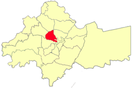
Al-Abdali is the 9th district in the Amman Governorate out of the 27 districts, it is named relative to King Abdullah I who founded it during the 1940s. It covers an area of 15 square kilometres (6 sq mi) in the heart of Amman, with a population of 165,333 in 2015. Large parts of the district are residential, but due its geographical location in the center of the city, it contains several important governmental buildings and businesses. The area is known for containing several bus stations serving routes to many cities in Jordan.

Shorbachy Vtoryye is a village in the Hajigabul Rayon of Azerbaijan.

Chynów is a village in Grójec County, Masovian Voivodeship, in east-central Poland. It is the seat of the gmina called Gmina Chynów. It lies approximately 16 kilometres (10 mi) east of Grójec and 35 km (22 mi) south of Warsaw.

Przeździecko-Lenarty is a village in the administrative district of Gmina Andrzejewo, within Ostrów Mazowiecka County, Masovian Voivodeship, in east-central Poland. It lies approximately 6 kilometres (4 mi) north-east of Andrzejewo, 25 km (16 mi) east of Ostrów Mazowiecka, and 112 km (70 mi) north-east of Warsaw.
Jaworowo-Kolonia is a village in the administrative district of Gmina Zawidz, within Sierpc County, Masovian Voivodeship, in east-central Poland.

Głoginin is a village in the administrative district of Gmina Borek Wielkopolski, within Gostyń County, Greater Poland Voivodeship, in west-central Poland. It lies approximately 7 kilometres (4 mi) south-east of Borek Wielkopolski, 21 km (13 mi) east of Gostyń, and 65 km (40 mi) south-east of the regional capital Poznań.

Ganiec is a village in the administrative district of Gmina Kamień Pomorski, within Kamień County, West Pomeranian Voivodeship, in north-western Poland. It lies approximately 11 kilometres (7 mi) south-east of Kamień Pomorski and 56 km (35 mi) north of the regional capital Szczecin.
Podłążek is a settlement in the administrative district of Gmina Myślibórz, within Myślibórz County, West Pomeranian Voivodeship, in north-western Poland.

Rahmania is a suburb of the city of Algiers in northern Algeria.
Kankandi is a village and rural commune in Niger.
Sabon-Machi is a village and rural commune in Niger.

The Diamantbuurt is a neighborhood of Amsterdam, The Netherlands. It was built in the 1930s. It has streets named after precious stones: Diamantstraat, Robijnstraat, Saffierstraat, Smaragdstraat, Topaasstraat and Granaatstraat. These days the Diamantbuurt includes the area enclosed by the Tweede van der Helststraat, Karel du Jardinstraat, Henrick de Keijserplein, Tolstraat, Amstel and Amstelkanaal. It has many special buildings and monuments, like social housing in the Amsterdam School style of architecture.

Ryūgasaki Airfield is an airfield in Ryūgasaki, Ibaraki Prefecture, Japan.

Nadalama is a village in Kehtna Parish, Rapla County in northern-central Estonia.
Naistevalla is a village in Märjamaa Parish, Rapla County in western Estonia.

Scheepvaartkwartier is a neighborhood of Rotterdam, Netherlands.

Aukštoji Freda Manor is a former residential manor in Freda, Kaunas.

KLCN was a radio station airing a Classic Hits format. Formally licensed to Blytheville, Arkansas, broadcasting on 910 kHz AM. The station served the areas of Blytheville, Arkansas, Dyersburg, Tennessee, Covington, Tennessee, and Kennett, Missouri for nearly 90 years. The station was owned by Sudbury Services, Inc.


