
North Decatur is an unincorporated community and census-designated place (CDP) in DeKalb County, Georgia, United States. The population was 18,511 in 2020.

North Druid Hills, also known as Briarcliff or Toco Hills, is an unincorporated community and census-designated place in DeKalb County, Georgia, United States. The population was 20,385 in 2020. The commercial center of the area is the Toco Hill Shopping Center, located near the intersection of North Druid Hills Road and LaVista Road.

Walker Mill is an unincorporated area and census-designated place (CDP) in Prince George's County, Maryland, United States. Per the 2020 census, the population was 12,187.

A skid row, also called skid road, is an impoverished area, typically urban, in English-speaking North America whose inhabitants are mostly poor people "on the skids". This specifically refers to people who are poor or homeless, considered disreputable, downtrodden or forgotten by society. A skid row may be anything from an impoverished urban district to a red-light district to a gathering area for people experiencing homelessness or drug addiction. In general, skid row areas are inhabited or frequented by impoverished individuals and also people who are addicted to drugs. Urban areas considered skid rows are marked by high vagrancy, dilapidated buildings, and drug dens, as well as other features of urban blight. Used figuratively, the phrase may indicate the state of a poor person's life.
Peppermill Village is an unincorporated community near Maryland Route 214 in Prince George's County, Maryland, United States. Per the 2020 census, the population was 5,264. FedExField, Metrorail's Blue Line, and Hampton Mall shopping center are all located nearby. Because it is not formally incorporated, it has no official boundaries, but the United States Census Bureau has defined a census-designated place (CDP) consisting of Peppermill Village and the adjacent community of Carmody Hills, for statistical purposes.
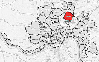
Bond Hill is one of the 52 neighborhoods of Cincinnati, Ohio. Founded as a railroad suburb and temperance community in 1870 in northeastern Millcreek Township, it is one of a number of neighborhoods lining the Mill Creek. The population was 7,002 at the 2020 census.
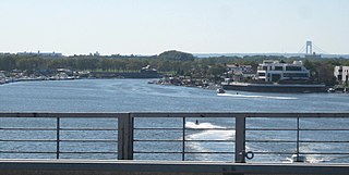
Mill Basin is a residential neighborhood in southeastern Brooklyn, New York City. It is on a peninsula abutting Jamaica Bay and is bordered by Avenue U on the northwest and the Mill Basin/Mill Island Inlet on its remaining sides. Mill Basin is adjacent to the neighborhood of Bergen Beach to the northeast, Flatlands to the northwest, Marine Park to the southwest, and Floyd Bennett Field and the former Barren Island to the southeast. Mill Basin also contains a subsection called Old Mill Basin, north of Avenue U.

Gulshan-e-Hadeed or Gulshan-e-Hadid is a residential neighborhood in the Bin Qasim Town of Malir District in Karachi, Pakistan.

Basauri is a major municipality of Biscay, in the Basque Country, an Autonomous Community in northern Spain.

Como is a neighborhood within the Southeast quadrant of Minneapolis. The neighborhood is also sometimes referred to as Southeast Como to help differentiate it from the Como Park neighborhood in neighboring Saint Paul. Its boundaries are East Hennepin Avenue to the north, 33rd Avenue Southeast to the east, the Southeast Industrial Area to the south, and Interstate 35W to the west. Como is also part of the University District in Minneapolis, with its location near the main Minneapolis campus of the University of Minnesota.

Parkwood is a neighborhood located in the Far Northeast section of Philadelphia, Pennsylvania, United States. The neighborhood's boundaries include the Byberry East Industrial Park to the north and northwest, Poquessing Creek to the east, Knights Road to the southeast and Woodhaven Road to the southwest. The neighborhood was developed by Hyman Korman in the 1960-1962 as a planned residential community. The predominant housing type is the brick row house. The Parkwood Shopping Center is a local shopping destination, while the Philadelphia Mills mall is a regional shopping destination on Knights Road to the east of Parkwood's residential area.

Oakley is one of the 52 neighborhoods of Cincinnati, Ohio. Located in the eastern part of the city, it borders Pleasant Ridge, Madisonville, and Hyde Park. Oakley is a primary thoroughfare and a major crosstown artery in Cincinnati, and contains multiple shopping centers. The population was 11,761 at the 2020 census.

Lampeter is an unincorporated community and census-designated place (CDP) in West Lampeter Township, Lancaster County, Pennsylvania, United States. As of the 2010 census, it had a population of 1,669. It is a suburb of Lancaster and has a ZIP code of 17537. The community was named after Lampeter, in Wales.

Utebo is a town located in the province of Zaragoza, Aragon, Spain. At the time of the 2011 census (INE), the municipality had a population of 18,602 inhabitants, being the third most populous town of the province, only surpassed by Zaragoza and Calatayud, and one of the most populous in Aragon.
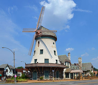
Bevo Mill is a neighborhood located in south St. Louis, Missouri.
Wyndham Downs is a neighborhood in southwestern Lexington, Kentucky, United States. Its boundaries are Man O War Boulevard and Old Higbee Mill Road to the north, Twain Ridge Road to the south, Clays Mill Road to the east, and Clemens Drive to the west.
Clemens Heights is a neighborhood in southwestern Lexington, Kentucky, United States. Its streets are all named after things associated with Mark Twain, whose real name was Samuel Clemens. Its boundaries are Old Higbee Mill Road to the north, Clemens Drive and Carevares Drive to the east, Copper Run Boulevard to the south, and Dogwood Park to the west.
Pasadena is a neighborhood in southwestern Lexington, Kentucky, United States. Its name is derived from its location just south of Pasadena Drive. All streets in the neighborhood are named after western American cities. Its boundaries are a combination of New Circle Road, Waco Road, and Nakomi Drive to the south, Harrodsburg Road to the west, Pasadena Drive to the north, and a combination of Waco Road and Clays Mill Road to the east.

Four Corners is a neighborhood and census-designated place (CDP) in Montgomery County, Maryland, United States. Many residents consider the neighborhood a part of Silver Spring, to whose CDP it belonged until 2010. It had a population of 8,316 at the 2020 census.
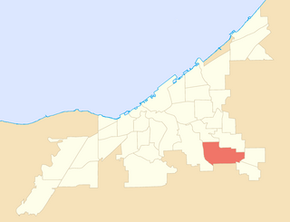
Union–Miles Park is a neighborhood on the Southeast side of Cleveland, Ohio, in the United States. The neighborhood draws its name from Union Avenue, and Miles Park in its far southwest corner.


