
The Hindu Kush is an 800-kilometre-long (500 mi) mountain range on the Iranian Plateau in Central and South Asia to the west of the Himalayas. It stretches from central and eastern Afghanistan into northwestern Pakistan and far southeastern Tajikistan. The range forms the western section of the Hindu Kush Himalayan Region (HKH); to the north, near its northeastern end, the Hindu Kush buttresses the Pamir Mountains near the point where the borders of China, Pakistan and Afghanistan meet, after which it runs southwest through Pakistan and into Afghanistan near their border.

The Helmand River is the longest river in Afghanistan and the primary watershed for the endorheic Sistan Basin. It originates in the Sanglakh Range of the Hindu Kush mountains in the northeastern part of Maidan Wardak Province, where it is separated from the watershed of the Kabul River by the Unai Pass. The Helmand feeds into the Hamun Lake on the border of Afghanistan and Iran.
Hazarajat, also known as Hazaristan is a mostly mountainous region in the central highlands of Afghanistan, among the Kuh-e Baba mountains in the western extremities of the Hindu Kush. It is the homeland of the Hazara people who make up the majority of its population. Hazarajat denotes an ethnic and religious zone.

The Sulaiman Mountains, also known as Kōh-e Sulaymān or Da Kasē Ghrūna, are a north–south extension of the southern Hindu Kush mountain system in Pakistan and Afghanistan. They rise to form the eastern edge of the Iranian plateau. They are located in the Kandahar, Zabul and Paktia provinces of Afghanistan, and in Pakistan they extend over the northern part of Balochistan and Waziristan as well as Kurram of Khyber Pakhtunkhwa. In southwestern Punjab, the mountains extend into the two districts of Dera Ghazi Khan and Rajanpur, which are located west of the Indus River on the boundary with Balochistan. Bordering the mountains to the east are the plains of the Indus River valley, and to the north are the arid highlands of the Central Hindu Kush whose heights extend up to 3,383 metres (11,099 ft). The total area on which this range spans around 6475 sq. km .Together with the Kirthar Mountains on the border between Balochistan and Sindh, the Sulaiman Mountains form what is known as the Sulaiman-Kirthar geologic province.

Parwan also spelled Parvan is one of the 34 provinces of Afghanistan. It is the largest province of the Greater Parwan region and has a population of about 751,000. The province is multi-ethnic and mostly rural society. The province is divided into ten districts. The town of Imam Abu Hanifa serves as the provincial capital. The province is located north of Kabul Province and south of Baghlan Province, west of Panjshir Province and Kapisa Province, and east of Maidan Wardak Province and Bamyan Province. The province's famous tourism attraction is the Golghondi Hill, also known as “the flower hill,” located in Imam Azam about an hour away from the capital city of Kabul. After Panjshir this province has been considered as one of the main raising points of Afghanistan War against Soviets.

The Kabul River, the classical Cophen, is a river that emerges in the Sanglakh Range of the Hindu Kush mountains in the northeastern part of Maidan Wardak Province, Afghanistan. It is separated from the watershed of the Helmand River by the Unai Pass. The Kabul River is a tributary of the Indus River, flowing into it near Attock, Pakistan. The Kabul is the main river in eastern Afghanistan and in the Khyber Pakhtunkhwa province of Pakistan.

The Salang Tunnel is a 2.67-kilometre-long (1.66 mi) tunnel located at the Salang Pass in northern Parwan Province of Afghanistan, about 90 km (56 mi) north of the nation's capital, Kabul. At nearly 3,200 m (10,500 ft) above sea level, the tunnel work was originally completed by the Soviet Union in 1964.

The Salang Pass is the primary mountain pass connecting northern Afghanistan with Parwan Province, with onward connections to Kabul Province, southern Afghanistan, and to the Pakistani province of Khyber Pakhtunkhwa. Located on the border of Parwan Province and Baghlan Province, it is just to the East of the Kushan Pass, and both of them were of great importance in early times as they provided the most direct connections between the Kabul region with northern Afghanistan or Tokharistan. The Salang River originates nearby and flows south.

The Hajigak Pass is a mountain pass of Afghanistan. It is situated at a height of 3,700 metres (12,100 ft) above sea-level in the northern part of Maidan Wardak province, connecting it with Bamyan province to the northwest. It is one of the two main routes from Kabul to Bamyan in Hazarajat, leading across the Koh-i-Baba range.

Mount Sikaram is a mountain on the Afghanistan–Pakistan border, south of the Kabul River and Khyber Pass. At 4,755 m (15,600 ft), it is the highest peak of the Spīn Ghar, or Safēd Kōh, mountain range.
Shibar, is a district located in the western end of the Bamyan province in Afghanistan. It is in a mountainous region. The capital city Shibar is at 2,637 m altitude on the all-seasons secondary road from Bamyan to Kabul through the Shibar Pass.

The Panjshir River flows through the Panjshir Valley in northeastern Afghanistan, 150 kilometres (93 mi) north of Kabul. Its main tributary is the Ghorband River which flows from the Parwan Province and joins the Panjshir River 10 km east of Charikar in Bagram District. The Panjshir River takes its source near the Anjuman Pass and flows southward through the Hindu Kush and joins the Kabul River at Surobi. A dam was built on the Panjshir River near Surobi in the 1950s to supply water from the Panjshir River to the Kabul River. There is just one permanent bridge on the Panjshir River that provides access to the Bagram Airport. On 12 July 2018, a flood in Panjshir Valley killed ten people.

The Kushan Pass or Kaoshan Pass is a mountain pass just west of the famous Salang Pass in the Hindu Kush mountain range of northern Afghanistan. These two passes provided the most direct, if difficult, routes across the imposing east–west wall of the Hindu Kush mountains which divide northern Afghanistan or Tokharistan from Kabul province, which is closely connected to southern Afghanistan and Pakistan. Nowadays, the Salang tunnel constructed by the Soviets in the 1960s, and the paved road through it make it by far the easiest route through the Hindu Kush Mountains.

The Kokcha River is located in northeastern Afghanistan. A tributary of the Panj river, it flows through Badakhshan Province in the Hindu Kush. It is named after the Koksha Valley. The city of Feyzabad lies along the Kokcha. Near the village of Artin Jelow there is a bridge over the river.
The Salang is a 438 kilometre long river of Afghanistan, flowing through Parwan Province. It is a tributary of the Indus River and the Ghorband River and the Panjshir River and the Kabul River.
The Kunduz River is a tributary of the Amu Darya in northern Afghanistan. It rises in Bamyan Province in the Hindu Kush, and in its upper reaches is also known as the Bamyan River or the Surkhab River. After passing through Baghlan Province and Kunduz Province, the Kunduz River merges into the Amu Darya.
Ghorband, also known as Syagird after its main town, is a district of Parwan province, Afghanistan. Ghorband is located in the southern foothills of Hindu Kush and forms the western boundary of the ancient valley of Koh Daman. It is located 50 km from Kabul, the capital of Afghanistan. The capital lies at the town of Siah Gerd. It is the largest district of the province, covering an area of 899 square kilometres with a population of 74,123 as of 2003. The Ghorband River flows through the district. It contains 58 Community Development Councils and 109 villages. Eventually, Gjorband valley was once much bigger then today reaching to the east Shibar, Doshi and Kahmard districts in Bamyan and Baghlan provinces.

As a mountainous country, Afghanistan contains countless notable valleys. The majority of the valleys are located in parts of northeastern, central, southern and southeastern Afghanistan. The southeastern areas are wetter and are covered by forest with trees such as cypress, oak, poplar, pine etc.

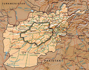
The central Afghan highlands, or the Afghan Highlands, is a geographic region of Afghanistan. Stretching from the Sabzak Pass near Herat in the west to the Little Pamir in the northeast, it includes the main Hindu Kush range and forms a western extension of the Himalayas. It is a highland area of more than 1,500 m above sea level, mostly situated between 2,000 and 3,000 m, with some peaks rising above 6,400 m. Usually, the valley bottoms in the area are used for cereal and horticultural production, and the mountains and high plateaus are used as pasture in summer for grazing sheep, goats, cattle, and camels. Its total area is about 414,000 km2.


