Ahtaj | |
|---|---|
 Ahtaj Location in Afghanistan | |
| Coordinates: 35°02′N69°15′E / 35.033°N 69.250°E | |
| Country | |
| Time zone | + 4.30 |
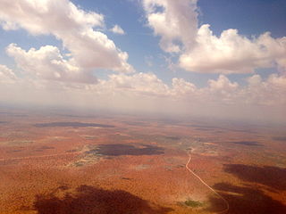
Ahtaj is a town in Afghanistan. [1] [2]
Ahtaj | |
|---|---|
| Ahtaj Location in Afghanistan | |
| Coordinates: 35°02′N69°15′E / 35.033°N 69.250°E | |
| Country | |
| Time zone | + 4.30 |
Ahtaj is a town in Afghanistan. [1] [2]
| Districts |  | |
|---|---|---|
| Populated places | ||
| Landforms | ||
| Other | ||
| | This Parwan Province, Afghanistan location article is a stub. You can help Wikipedia by expanding it. |

A geographic coordinate system (GCS) is a coordinate system associated with positions on Earth. A GCS can give positions:

A circle of latitude or line of latitude on Earth is an abstract east–west small circle connecting all locations around Earth at a given latitude coordinate line.

Avalon is a federal electoral district on Newfoundland Island in Newfoundland and Labrador, Canada. It has been represented in the House of Commons of Canada since 2004.
ISO 6709, Standard representation of geographic point location by coordinates, is the international standard for representation of latitude, longitude and altitude for geographic point locations.

The 30th parallel north is a circle of latitude that is 30 degrees north of the Earth's equatorial plane. It stands one-third of the way between the equator and the North Pole and crosses Africa, Asia, the Pacific Ocean, North America and the Atlantic Ocean. The parallel is used in some contexts to delineate Europe or what is associated with the continent of Europe as a southernmost limit, e.g. to qualify for membership of the European Broadcasting Union.
This is a list of properties and historic districts listed on the National Register of Historic Places in Norfolk County, Massachusetts, other than those within the city of Quincy and the towns of Brookline and Milton. Norfolk County contains more than 300 listings, of which the more than 100 not in the above three communities are listed below. Some listings extend across municipal boundaries, and appear on more than one list.

List of the National Register of Historic Places listings in Dutchess County, New York
Wajir is the capital of the Wajir County of Kenya. It is situated in the former North Eastern Province. The town lies approximately a very large area it's situated between Garissa Mandera and Isiolo counties Centre the town is mainly populated by the Degodia clan of Somali followed by the Ogaden and the Ajuran.

Ab Khuda'i or Abzi Khuda'i is a village in the west of Ab Kamari District in Herat Province, of north-west Afghanistan. Its population, consists of approximately 90% Tajik with a small Pashtun, Aimaq and Uzbek minority. Other localities include Alkhan, Anjir, Duzdanak, Gana Gul, Khalifa, and Papal. The village used to be in Badghis Province.

Umegaoka Station is a station on the Odakyu Odawara line, located in Setagaya, Tokyo and is operated by Odakyu Railways.

Narang, Kunar, Afghanistan نرنګ in Pashto and Persian is situated in the central part of Kunar Province, Afghanistan south of Asadabad. It is surrounded by high mountains and the Kunar River. The population is 36,700 (2014). The district center is the village of Kuz Narang at 742 m altitude. It is the kunar 2nd largest district regarding Agriculture Land. The irrigation system is under rehabilitation.The land is in much good condition and fertile. The irrigation system is almost the best in Kunar province. About 75% of the people are educated. The famous villages are: 1: Bar-Narhang 2: Kotkay 3: Badel dara 4: kuz-Narhang 5: Lamatak 6: dandona 7: Char qala 8: kodo ; etc.
Uxbridge, Massachusetts has 53 sites on the National Register of Historic Places.
Shinkay District is a district of Zabul Province in southern Afghanistan. It has a population of about 22,900 as of 2013. It contains the town of Ẕāmi Kalay.
The 26th parallel north is a circle of latitude that is 26 degrees north of the Earth's equatorial plane. It crosses Africa, Asia, the Indian Ocean, the Pacific Ocean, North America and the Atlantic Ocean.
This is a list of the National Register of Historic Places listings in Boulder County, Colorado.

This is a list of the National Register of Historic Places listings in York County, Maine.

The twelve sacred hills of Imerina are hills of historical significance to the Merina people of Madagascar. Located throughout Imerina, the central area of the highlands of Madagascar, the sites were often ancient capitals, the birthplaces of key public figures, or the tomb sites of esteemed political or spiritual leaders. The first set of sacred sites was designated by early 17th-century king Andrianjaka. The notion was re-sanctified under late 18th-century king Andrianampoinimerina, who replaced several of the earlier sites with new ones. More than 12 sites were thus designated as sacred over time, although the notion of twelve sacred hills was perpetuated because of the significance of the number 12 in Malagasy cosmology. Today, little concrete evidence of the former importance of many of these sites remains, but the significant archeological and cultural heritage of several of the sites has been preserved. The historic significance of the sites is best represented by the Rova of Antananarivo at Analamanga, the ancient fortified city at Alasora, the houses and tombs of the andriana at Antsahadinta and the ancient fortifications and palaces at Ambohimanga, protected as a UNESCO World Heritage Site since 2001.

This is a list of the National Register of Historic Places listings in Washington County, Missouri.

The Cessna Citation Longitude is a business jet produced by Cessna, part of the Cessna Citation family. Announced at the May 2012 EBACE, the Model 700 made its first flight on October 8, 2016, with certification obtained in September 2019. The aluminum airframe has the fuselage cross-section of the Citation Latitude, stretched by a seat row. Powered by Honeywell HTF7000 turbofans, it has a new ~28° swept wing and a T-tail for a 3,500 nmi (6,500 km) range.
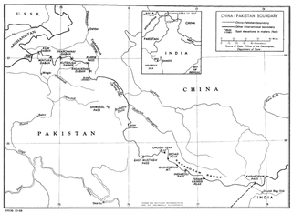
The China–Pakistan border is 596 kilometres (370 mi) and runs west-east from the tripoint with Afghanistan to the disputed tripoint with India in the vicinity of the Siachen Glacier. It traverses the Karakorum Mountains, one of the world's tallest mountain ranges. Hunza District, Shigar District and Ghanche District in Gilgit-Baltistan administered by Pakistan border Taxkorgan Tajik Autonomous County and Kargilik/Yecheng County in Kashgar Prefecture, Xinjiang Uygur Autonomous Region, China.