Alberta Provincial Highway No. 1A is the designation of two alternate routes off the Alberta portion of the Trans-Canada Highway. However, it is not the only name used for spurs off Highway 1 - Highway 1X is another such designation. These highways, however, are not part of the Trans-Canada Highway network, and only have Alberta's provincial primary highway shields instead of the ones used for the Trans-Canada Highway.

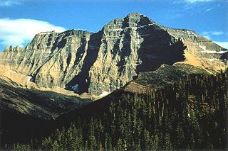
Mount Cleveland is the highest mountain in Glacier National Park, located in Montana, United States. It is also the highest point in the Lewis Range, which spans part of the northern portion of the Park and extends into Canada. It is located approximately 3 mi (4.8 km) southeast of the southern end of Waterton Lake, and approximately 5 mi (8.0 km) south of the US/Canada border. The east side of the future national park was purchased by the federal government from the Blackfoot Confederacy in 1895 during the second term of President Cleveland. According to the United States Board on Geographic Names, the mountain is named for the former president.

Alberta Provincial Highway No. 20, commonly referred to as Highway 20, is a highway in central Alberta, Canada, west of Highway 2.

Alberta Provincial Highway No. 40, commonly referred to as Highway 40, is a south-north highway in western Alberta, Canada. It is also named Bighorn Highway and Kananaskis Trail in Kananaskis Country. Its segmented sections extend from Coleman in the Municipality of Crowsnest Pass northward to the City of Grande Prairie and is currently divided into four sections.
Highway 624 is a highway in the Canadian province of Saskatchewan. It is divided into three sections.

Bivouac Peak is in the northern Teton Range, Grand Teton National Park, Wyoming. The peak is located immediately to the west of Moran Bay on Jackson Lake, and rises more than 4,000 ft (1,200 m) in less than 0.5 mi (0.80 km) from the lakeshore. Moran Canyon is situated to the south of the mountain and Snowshoe Canyon lies to the north.

Ingraham Glacier is on the south-eastern flank of Mount Rainier, in the U.S. state of Washington. The glacier is named for the Mount Rainier enthusiast Edward Sturgis Ingraham. From the summit ice cap, Ingraham Glacier flows east between Gibraltar Rock,, and Disappointment Cleaver and south of Little Tahoma Peak, which divides it from the much larger Emmons Glacier to the north. Descending southeast, it approaches the east flank of Cowlitz Glacier and the two glaciers nearly join at 6,700 ft (2,000 m). Meltwater from the glacier drains into the Cowlitz River.

Del Bonita is a hamlet in southern Alberta, Canada within Cardston County. It is located approximately 49 km (30 mi) south of Magrath at the junction of Highway 62 and Highway 501. It serves as a port of entry into the U.S. state of Montana at the nearby Canada – United States border crossing 3 km (1.9 mi) to the south. Del Bonita is a name derived from Spanish meaning "of the pretty".

Diobsud Creek Glacier is in North Cascades National Park in the U.S. state of Washington and is on the east slopes of Bacon Peak. Diobsud Creek Glacier has a shallow gradient, descending to the east from 7,000 to 6,000 ft for a distance of nearly 1 mi (1.6 km). The ridge is an arête which separates Diobsud Creek Glacier from Green Lake Glacier to the north.

Katsuk Glacier is in North Cascades National Park in the U.S. state of Washington, in a cirque to the north of Katsuk Peak and east of Kimtah Peak. Both Katsuk and Kimtah Peaks are prominent summits along a ridge known as Jagged Edge. Katsuk Glacier consists of three disconnected sections, the largest of which stretches for over 1 mi (1.6 km) in width. Kimtah Glacier is immediately west of Katsuk Glacier, while the Mesahchie Glacier lies to the east.

Kimtah Glacier is in North Cascades National Park in the U.S. state of Washington, in a cirque to the west of Kimtah Peak and east of Cosho Peak. Both Kimtah and Cosho Peaks are prominent summits along a ridge known as Jagged Edge. Kimtah Glacier is just under 1 mi (1.6 km) in width and descends northward from 8,100 to 7,000 ft and has four lobes.

Whatcom Glacier is in North Cascades National Park in the U.S. state of Washington, in a cirque to the northeast of Whatcom Peak. Whatcom Glacier is approximately .50 mi (0.80 km) north of Challenger Glacier.

Katsuk Peak, elevation 8,680+ ft, is in North Cascades National Park in the U.S. state of Washington. Katsuk Peak is a summit along a ridge known as Jagged Edge. Katsuk Glacier is on the north slopes of the peak. Katsuk Peak is separated from Mesahchie Peak by a distance of only .25 mi (0.40 km).

Mesahchie Peak is in North Cascades National Park in the U.S. state of Washington. Mesahchie Peak is named after the Chinook word for wicked. Mesahchie Peak is the highest summit along a ridge known as Ragged Ridge and is only .25 mi (0.40 km) east of Katsuk Peak. Both the Katsuk and Mesahchie Glaciers descended down the northwest and northeast flanks of the peak respectively.

Phantom Peak is in North Cascades National Park in the U.S. state of Washington. Located in the northern section of the park, Phantom Peak is in the Picket Range and is 1 mi (1.6 km) northwest of Mount Fury and .50 mi (0.80 km) south of Crooked Thumb Peak.

Crooked Thumb Peak is in North Cascades National Park in the U.S. state of Washington. Located in the northern section of the park, Crooked Thumb Peak is in the Picket Range and is .50 mi (0.80 km) south of Mount Challenger and the same distance north of Phantom Peak.

McMillan Spire is a mountain peak in the Picket Range in the U.S. state of Washington and within North Cascades National Park. The peak lies .75 mi (1.21 km) east of Mount Degenhardt. The subpeak known as East McMillan Spire is .14 mi (0.23 km) east of McMillan Spire and they are collectively referred to as the McMillan Spires. The Terror Glacier lies to the west of the peak.

Poltergeist Pinnacle is in North Cascades National Park in the U.S. state of Washington. Located in the northern section of the park, Poltergeist Pinnacle is in the Picket Range and is .09 mi (0.14 km) south of Mount Challenger and for all basic purposes, is one of the main pinnacles of Mount Challenger.


