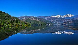
Langtang Valley also known as Lamtang Valley is a Himalayan valley in the mountains of north-central Nepal, known for its trekking routes and natural environment.

Kaski District, a part of Gandaki Province, is one of the seventy-seven districts of Nepal. The name is disambiguated from Kaskikot, the ancient Kaski Kingdom.
Himani, Crown Princess of Nepal is the wife of the former heir apparent to the throne of Nepal, Crown Prince Paras.
Patarasi is a rural municipality located in Jumla District of Karnali Province of Nepal.
Deurali is a Village Development Committee in Kaski District of the Gandaki province of north-central Nepal. At the time of the 1991 Nepal census, it had a population of 2,882. The base camp of Mount Machapuchare is situated at a 6-hour uphill trek from the village.
Hardauna is a village in the sub-metropolitan municipality of Maharajganj in the Kapilvastu District of the Lumbini Province. The village is in a terai region in southern Nepal. It is on the Banganga, a river which arises on the southern slopes of the Sivalik Hills and flows across the Terai, reaching into Uttar Pradesh state in India.

The Public Service Commission of Nepal was established on 15 June 1951. It is the main constitutional body involved in selecting meritorious candidates required by Government of Nepal for Civil Service Vacancy. It is regarded as one of the most credible modes of recruitment by Nepalis. The Constitution of Nepal has regarded the commission as an independent constitutional body.

The Nepalese Ministry of Minister of Industry, Commerce and Supplies is a governmental body of Nepal to monitor and manage industries of the country.

In the afternoon of 25 April 2015, a MW 7.8 earthquake struck Nepal and surrounding countries. Tremors from the quake triggered an avalanche from Pumori into Base Camp on Mount Everest. At least twenty-two people were killed, surpassing the toll of an avalanche that occurred in 2014 as the deadliest disaster on the mountain.

Phulsiri is a 2016 Gurung Language Nepali fiction film written, produced and directed by Ngima Gelu Lama. The film tells a deceptively simple account of tramautized schoolgirl's quest to her shoes, since, her school is reopening one and half months after the devastating Gorkha earthquake. The film is the first fiction film to be filmed in Gorkha, the epicentre of Nepal earthquake 2015 after the earthquake. The film won Best Children Film in Nepal Culture international Film Festival.
Bheri is an urban municipality located in Jajarkot District of Karnali Province of Nepal.
Raskot is an urban municipality located in Kalikot District of Karnali Province of Nepal.
Bhairabi Rural Municipality is a rural municipality located in Dailekh District of Karnali Province of Nepal. The total area of the rural municipality is 110.46 square kilometres (42.65 sq mi) and the total population of the rural municipality as of 2011 Nepal census is 21,233 individuals. The rural municipality is divided into total 7 wards. A small portion of Dullu municipality with Bhairi Kalikathum, Kusapani, Rawalkot and Kasikandh Village development committees were incorporated to form this new rural municipality. The headquarters of the municipality is situated at Bhairi Kalikathum.
Sinja is a rural municipality located in Jumla District of Karnali Province of Nepal.
Thantikandh is a rural municipality located in Dailekh District of Karnali Province of Nepal.

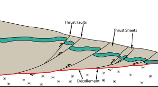
The Main Himalayan Thrust (MHT) is a décollement under the Himalaya Range. This thrust fault follows a NW-SE strike, reminiscent of an arc, and gently dips about 10 degrees towards the north, beneath the region. It is the largest active continental megathrust fault in the world.
Sarawal is a Rural municipality in the Parasi District of the Lumbini Province of Nepal. The rural municipality spans 73.19 square kilometres (28.26 sq mi) of area, with a total population of 38,163, according to a 2011 Nepal census.
The 2024 Nepal earthquake series includes 22 recorded seismic events throughout the year, reflecting Nepal's status as an active earthquake region. The largest earthquake, measuring 5.2 in magnitude, occurred on December 20, 2024 , at 04:14 local time . Its epicenter was located in Bajura District, at latitude 29.37°N and longitude 81.64°E. The tremors were felt across parts of Nepal and India, though no significant damage or casualties were reported.
This page is based on this
Wikipedia article Text is available under the
CC BY-SA 4.0 license; additional terms may apply.
Images, videos and audio are available under their respective licenses.


