Related Research Articles
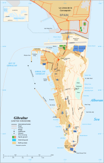
The Rock of Gibraltar is a monolithic limestone promontory located in the British territory of Gibraltar, near the southwestern tip of Europe on the Iberian Peninsula. It is 426 m (1,398 ft) high. Most of the Rock's upper area is covered by a nature reserve, which is home to around 300 Barbary macaques. These macaques, as well as a labyrinthine network of tunnels, attract many tourists each year.

St. Michael's Cave or Old St. Michael's Cave is the name given to a network of limestone caves located within the Upper Rock Nature Reserve in the British Overseas Territory of Gibraltar, at a height of over 300 metres (980 ft) above sea level. According to Alonso Hernández del Portillo, the first historian of Gibraltar, its name is derived from a similar grotto in Monte Gargano near the Sanctuary of Monte Sant'Angelo in Apulia, Italy, where the archangel Michael is said to have appeared.

The Gibraltar Nature Reserve is a protected nature reserve in the British Overseas Territory of Gibraltar that covers over 40% of the country's land area. It was established as the Upper Rock Nature Reserve in 1993 under the International Union for Conservation of Nature's category Ia and was last extended in 2013. It is known for its semi-wild population of Barbary macaques, and is an important resting point for migrating birds.

Lord Airey's Battery is an artillery battery in the British Overseas Territory of Gibraltar. It is located near the southern end of the Upper Rock Nature Reserve, just north of O'Hara's Battery. It was named after the Governor of Gibraltar, General Sir Richard Airey. Construction of the battery was completed in 1891. The first gun mounted on the battery was a 6-inch breech loading gun, which was replaced with a 9.2-inch Mark X BL gun by 1900. The gun at the battery was last fired in the 1970s. In 1997, it was discovered that Lord Airey's Shelter, adjacent to Lord Airey's Battery, was the site chosen for a covert World War II operation that entailed construction of a cave complex in the Rock of Gibraltar, to serve as an observation post. The battery is listed with the Gibraltar Heritage Trust.

Princess Royal's Battery is an artillery battery in the British Overseas Territory of Gibraltar. It is located on Willis's Plateau at the northern end of the Upper Rock Nature Reserve, just southeast of Princess Anne's Battery. Formerly known as Willis' Battery, and later, Queen Anne's Battery or Queen's Battery, it was renamed in the late 18th century after Charlotte, Princess Royal, the eldest daughter of George III. The battery was active from the early 18th century until at least the mid-20th century. However, it has been decommissioned and guns are no longer present. Princess Royal's Battery is listed with the Gibraltar Heritage Trust.

Breakneck Battery is an artillery battery in the British Overseas Territory of Gibraltar. It is located on Ministry of Defence property at the Upper Rock Nature Reserve, north of Lord Airey's Battery. It is one of a dozen batteries in Gibraltar that had 9.2-inch (233.7 mm) guns installed around the turn of the twentieth century. The emplacement features a 9.2-inch Mark X breech-loading gun on a Mark V mounting. The battery was refurbished by 10 Signal Regiment in 2012 and 2016 whilst being on Ceremonial duties whilst the Gibraltar Regiment where on exercise and is one of three surviving 9.2-inch gun emplacements at the Upper Ridge of the Rock of Gibraltar. By the late twentieth century, the 9.2-inch guns in Gibraltar, Bermuda, Portugal, South Africa, and Australia were the remaining examples of an emplacement that at one point had been mounted at strategic locations across the British Empire.

Levant Battery is an artillery battery in the British Overseas Territory of Gibraltar. It is located on Windmill Hill, at the southern end of the Upper Rock Nature Reserve, below observation post Fire Control South. It was named after the Levanter cloud, below which it perched, giving it an unobstructed view. Construction started in 1901 and, by 1903, a 9.2-inch Mark X breech-loading gun had been mounted. The battery was decommissioned in the 1970s and the gun was later removed, to rest in a scrap yard. A community group has been formed to garner support for the gun's recovery and restoration.
Middle Hill is a hill in the British Overseas Territory of Gibraltar. It is located at the northern end of the Upper Rock Nature Reserve. It figured prominently in the early history of the 1704 siege of Gibraltar by the Spanish and French. The artillery battery at Middle Hill had been constructed by 1727 and was active for more than two centuries. In the mid twentieth century, Middle Hill transitioned to use as an aerial farm for the Ministry of Defence. The radio farm was refurbished in 1958. About 1970, the Princess Caroline's Battery Group of Barbary macaques were moved to Middle Hill, where they were provisioned at a group of derelict buildings that were part of the battery complex. In 2005, much of Middle Hill was transferred from the Ministry of Defence to the Government of Gibraltar, and is now managed by the Gibraltar Ornithological and Natural History Society.
Bray's Cave is a limestone cave in the British Overseas Territory of Gibraltar. Human remains and notable Neolithic and Bronze Age finds have been unearthed in the cave. Three almost complete skulls were recovered but the important find was that people had returned to the site to re-use it for funerals, other cranial fragments from other individuals were recovered, and it appeared that previous remains had been move aside for a more recent death.
Fig Tree Cave is a cave in the British Overseas Territory of Gibraltar. It is located on the eastern cliffs of the Rock of Gibraltar, not far from Martin's Cave within the Upper Rock Nature Reserve.

Pete's Paradise Cave is a cave in the British Overseas Territory of Gibraltar. Explored in the 1960s and 1970s by a team led by George Palao, four skeletons have been unearthed in the cave, two of which were female skeletons with crushed skulls.

Douglas Cave is a cave in the British Overseas Territory of Gibraltar.
George's Bottom Cave is a cave in the British Overseas Territory of Gibraltar. This together with Tina's Fissure and Levant Cave are a close group of three caves at the southern end of the Upper Rock Nature Reserve.
Levant Cave is a cave in the British Overseas Territory of Gibraltar. Together with Tina's Fissure and George's Bottom Cave, Levant Cave is part of a close group of three caves at the southern end of the Upper Rock Nature Reserve.
Tina's Fissure is a cave in the British Overseas Territory of Gibraltar. Tina's Fissure, George's Bottom Cave and Levant Cave are a close group of three caves at the southern end of the Upper Rock Nature Reserve.
Spider Cave is a limestone cave in the British Overseas Territory of Gibraltar. It is located within the Upper Rock Nature Reserve.

Queen's Road is the longest road in the British Overseas Territory of Gibraltar. It runs north–south through the Upper Rock Nature Reserve on the Rock of Gibraltar. It forks into Old Queen's Road which runs almost parallel with it for some part. The narrow road is halfway up the Rock and overlooks the Bay of Gibraltar. St. Michael's Cave lies off this road on Spur Battery Road. This is a large show cave featuring stalactites and stalagmites and an auditorium large enough to take orchestras. Also of note, apart from the nature reserve, are the Great Siege Tunnels at the northern end.

Mediterranean Steps is a path and nature trail in the British Overseas Territory of Gibraltar. One of the footpaths of Gibraltar, the path is located entirely within the Upper Rock Nature Reserve and was built by the British military but is now used by civilians as a pedestrian route linking Martin's Path to Lord Airey's Battery near the summit of Rock of Gibraltar. The path offers views over the Strait of Gibraltar, Windmill Hill, Europa Point, the Great Sand Dune, Gibraltar's east side beaches, the Mediterranean Sea and the Spanish Costa del Sol.
The footpaths of Gibraltar provide access to key areas of the Upper Rock Nature Reserve, a refuge for hundreds of species of flora and fauna which in some cases are found nowhere else in Europe. The reserve occupies the upper part of the Rock of Gibraltar, a long and narrow mountain that rises to a maximum height of 424 metres (1,391 ft) above sea level, and constitutes around 40 per cent of Gibraltar's total land area. The unusual geology of the Rock of Gibraltar – a limestone peak adjoining a sandstone hinterland – provides a habitat for plants and animals, such as the Gibraltar candytuft and Barbary partridge, which are found nowhere else in mainland Europe. For many years, the Upper Rock was reserved exclusively for military use; it was fenced off for military purposes, but was decommissioned and converted into a nature reserve in 1993.
References
- ↑ "Location of Caves - Gibraltar". Scribd . Retrieved 17 February 2013.
- 1 2 Perez, Charles E. (2005). Upper Rock Nature Reserve (PDF). Gibraltar Ornithological & Natural History Society.
| | This Gibraltar location article is a stub. You can help Wikipedia by expanding it. |