
The Rock of Gibraltar is a monolithic limestone mountain 426 m (1,398 ft) high dominating the western entrance to the Mediterranean Sea. It is situated near the end of a narrow 9 kilometres (5.6 mi) long promontory stretching due south into the Mediterranean Sea and is located within the British territory of Gibraltar, and is 27 km north-east of Tarifa, Spain, the southwestern tip of Europe on the Iberian Peninsula. The rock serves as an impregnable fortress and contains a labyrinthine network of man-made tunnels known as the Tunnels of Gibraltar. Most of the Rock's upper area comprises a nature reserve which is home to about 300 Barbary macaques. It is a major tourist attraction.

RFA Bedenham was a naval armament carrier of the British Royal Fleet Auxiliary that exploded while docked in Gibraltar on 27 April 1951, killing 13 people and causing a great deal of damage to the town.

The military history of Gibraltar during World War II exemplifies Gibraltar's position as a British fortress from the early-18th century onwards and as a vital factor in British military strategy, both as a foothold on the continent of Europe, and as a bastion of British sea power. During World War II, Gibraltar served a vital role in both the Atlantic Theatre and the Mediterranean Theatre, controlling virtually all naval traffic moving between the Mediterranean Sea and the Atlantic Ocean.
HMS L26 was a L-class submarine built for the Royal Navy during World War I. The boat was not completed before the end of the war and was one of three L-class boats to serve during World War II. She was sunk as a target in 1946.

General Sir Charles Frederic Keightley, was a senior British Army officer who served during and following the Second World War. After serving with distinction during the Second World War – becoming, in 1944, the youngest corps commander in the British Army – he had a distinguished postwar career and was the Governor of Gibraltar from 1958 to 1962.

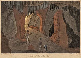
St. Michael's Cave or Old St. Michael's Cave is the name given to a network of limestone caves located within the Upper Rock Nature Reserve in the British Overseas Territory of Gibraltar, at a height of over 300 metres (980 ft) above sea level. According to Alonso Hernández del Portillo, the first historian of Gibraltar, its name is derived from a similar grotto in Monte Gargano near the Sanctuary of Monte Sant'Angelo in Apulia, Italy, where the archangel Michael is said to have appeared.

Capital punishment in Gibraltar included public execution in the nineteenth century until 1864. The last sentence of death was passed in 1952. Under British law, capital punishment was almost abolished in 1965, in line with British practice. It was entirely abolished in 2002 along with all other British Overseas Territories.

Flat Bastion is a bastion which projects southward from the Charles V Wall in the British Overseas Territory of Gibraltar. Once known as the St. Jago's Bastion or the Baluarte de Santiago in Spanish, the fortification was built by the Spanish in the mid 16th century and formed part of the southern defences of the city of Gibraltar, together with Charles V Wall, Southport Gates, Southport Ditch, and South Bastion. In 1859, six guns, four 12-pounders and two 12-pound carronades, were installed on the bastion, and four years later, five 32-pounders were mounted on the fortification.

Lord Airey's Battery is an artillery battery in the British Overseas Territory of Gibraltar. It is located near the southern end of the Upper Rock Nature Reserve, just north of O'Hara's Battery. It was named after the Governor of Gibraltar, General Sir Richard Airey. Construction of the battery was completed in 1891. The first gun mounted on the battery was a 6-inch breech loading gun, which was replaced with a 9.2-inch Mark X BL gun by 1900. The gun at the battery was last fired in the 1970s. In 1997, it was discovered that Lord Airey's Shelter, adjacent to Lord Airey's Battery, was the site chosen for a covert World War II operation that entailed construction of a cave complex in the Rock of Gibraltar, to serve as an observation post. The battery is listed with the Gibraltar Heritage Trust.
Operation Tracer was a secret Second World War Royal Navy military operation in Gibraltar, a British Overseas Territory and military base. The impetus for the stay-behind plan was the 1940 scheme by Germany to capture Gibraltar, code-named Operation Felix. Operation Tracer was the brainchild of Rear Admiral John Henry Godfrey, the Director of the Naval Intelligence Division of the Admiralty.

Coaling Island is an area of reclaimed land in the British Overseas Territory of Gibraltar. It is located at the centre of the western end of Gibraltar Harbour as one of its industrial zones. It also serves to harbour Cormorant Camber which berths small boats. The Royal Gibraltar Yacht Club was located there after the Ministry of Defence Boat Squadron freed up the site.
Poca Roca Cave is a cave in the British Overseas Territory of Gibraltar.

Monkey's Cave is a cave in the British Overseas Territory of Gibraltar. It has been used as part of the Fortifications of Gibraltar and in 1942 there was a convalescent hospital here. This building was later used as the HQ of the Royal Electrical & Mechanical Engineers.
Boathoist Cave, also known as Bulman's Cave, is a huge sea cave on the south eastern flank of the British Overseas Territory of Gibraltar.

Signal Hill Battery or Signal Battery was an artillery battery in the British Overseas Territory of Gibraltar. The battery was mounted high on the rock. Little remains today as the Gibraltar Cable Car top station was built on the site of the old battery.

Ragged Staff Gates are a set of city gates in the British Overseas Territory of Gibraltar. They are located between South Bastion and Ragged Staff Guard, opposite the Navy Boat Sheds.

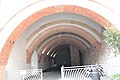
The Great North Road is a large road tunnel in the British Overseas Territory of Gibraltar. It was constructed by the British military during World War II inside the Rock of Gibraltar and remains property of the Ministry of Defence to this day. The road allowed lorries to travel from the north to the south of Gibraltar entirely within the Rock. The tunnel still contains the remains of World War II buildings such as Nissen huts, kitchens, offices as well as a generating station and period anti-submarine nets.

The tunnels of Gibraltar were constructed over the course of nearly 200 years, principally by the British Army. Within a land area of only 2.6 square miles (6.7 km2), Gibraltar has around 34 miles (55 km) of tunnels, nearly twice the length of its entire road network. The first tunnels, excavated in the late 18th century, served as communication passages between artillery positions and housed guns within embrasures cut into the North Face of the Rock. More tunnels were constructed in the 19th century to allow easier access to remote areas of Gibraltar and accommodate stores and reservoirs to deliver the water supply of Gibraltar.

Windmill Hill or Windmill Hill Flats is one of a pair of plateaux, known collectively as the Southern Plateaux, at the southern end of the British Overseas Territory of Gibraltar. It is located just to the south of the Rock of Gibraltar, which descends steeply to the plateau. Windmill Hill slopes down gently to the south with a height varying from 120 metres (390 ft) at the north end to 90 metres (300 ft) at the south end. It covers an area of about 19 hectares, though about 6 hectares at the north end is built over. The plateau is ringed to the south and east with a line of cliffs which descend to the second of the Southern Plateaux, Europa Flats, which is itself ringed by sea cliffs. Both plateaux are the product of marine erosion during the Quaternary period and subsequent tectonic uplift. Windmill Hill was originally on the shoreline and its cliffs were cut by the action of waves, before the ground was uplifted and the shoreline moved further out to the edge of what is now Europa Flats.
HMS Limbourne (L57) was a Hunt-class escort destroyer, operated by the Royal Navy. She was sunk in action, off German-occupied Guernsey, on 23 October 1943.
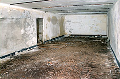
 Entrance tunnel
 Internal tunnel
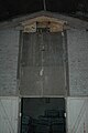 One of the magazines
 Another magazine


