
Operation Felix was the codename for a proposed German Wehrmacht campaign to cross into Spain and to seize Gibraltar early in the Second World War. The planned operation presupposed the co-operation of the Spanish dictator, Francisco Franco; it did not occur chiefly because of Franco's reluctance to enter the war - partially due to the influence of British intelligence.

The Rock of Gibraltar is a monolithic limestone mountain 426 m (1,398 ft) high dominating the western entrance to the Mediterranean Sea. It is situated near the end of a narrow 9 kilometres (5.6 mi) long promontory stretching due south into the Mediterranean Sea and is located within the British territory of Gibraltar, and is 27 km north-east of Tarifa, Spain, the southwestern tip of Europe on the Iberian Peninsula. The rock serves as an impregnable fortress and contains a labyrinthine network of man-made tunnels known as the Tunnels of Gibraltar. Most of the Rock's upper area comprises a nature reserve which is home to about 300 Barbary macaques. It is a major tourist attraction.
The Royal Regiment of Fusiliers is an infantry regiment of the British Army, part of the Queen's Division. Currently, the regiment has two battalions: the 1st Battalion, part of the Regular Army, is an armoured infantry battalion based in Tidworth, Wiltshire, and the 5th Battalion, part of the Army Reserve, recruits in the traditional fusilier recruiting areas across England. The Royal Regiment of Fusiliers was largely unaffected by the infantry reforms that were announced in December 2004, but under the Army 2020 reduction in the size of the Army, the 2nd Battalion was merged into the first in 2014.
The Queen's Lancashire Regiment (QLR) was an infantry regiment of the British Army, part of the King's Division. It was formed on 25 March 1970 at Connaught Barracks in Dover through the amalgamation of the two remaining Lancashire infantry regiments, the Lancashire Regiment and the Loyal Regiment. In July 2006 the regiment was amalgamated with two other Northern infantry regiments to form the Duke of Lancaster's Regiment.

The Duke of Lancaster's Regiment (LANCS) is an infantry regiment of the line within the British Army, part of the King's Division. Headquartered in Preston, it recruits throughout the North West of England. The title of Duke of Lancaster merged with the Crown on the accession of Henry V in 1413 and remains dormant, subject to any future revival. Customarily, however, the Sovereign is referred to as the Duke of Lancaster within Lancashire and in relation to the Duchy of Lancaster, and is the regiment's Colonel in Chief. The Duke of Lancaster's Regiment is the county regiment for Cumbria, Lancashire, Greater Manchester, Merseyside and the Isle of Man, and as such, recruits mainly from these areas.

The Jeita Grotto is a system of two separate, but interconnected, karstic limestone caves spanning an overall length of nearly 9 kilometres (5.6 mi). The caves are situated in the Nahr al-Kalb river valley within the locality of Jeita, 18 kilometres (11 mi) north of the Lebanese capital Beirut. Though inhabited in prehistoric times, the lower cave was not rediscovered until 1836 by Reverend William Thomson; it can only be visited by boat since it channels an underground river that provides fresh drinking water to more than a million Lebanese.

HQ Northern Ireland was the formation responsible for the British Army in and around Northern Ireland. It was established in 1922 and disbanded, replaced by a brigade-level Army Reserve formation, 38 (Irish) Brigade, in 2009.

The military history of Gibraltar during World War II exemplifies Gibraltar's position as a British fortress from the early-18th century onwards and as a vital factor in British military strategy, both as a foothold on the continent of Europe, and as a bastion of British sea power. During World War II, Gibraltar served a vital role in both the Atlantic Theatre and the Mediterranean Theatre, controlling virtually all naval traffic moving between the Mediterranean Sea and the Atlantic Ocean.

The Great Siege Tunnels in the British Overseas Territory of Gibraltar, also known as the Upper Galleries, are a series of tunnels inside the northern end of the Rock of Gibraltar. They were dug out from the solid limestone by the British during the Great Siege of Gibraltar of the late 18th century.

St. Michael's Cave or Old St. Michael's Cave is the name given to a network of limestone caves located within the Upper Rock Nature Reserve in the British Overseas Territory of Gibraltar, at a height of over 300 metres (980 ft) above sea level. According to Alonso Hernández del Portillo, the first historian of Gibraltar, its name is derived from a similar grotto in Monte Gargano near the Sanctuary of Monte Sant'Angelo in Apulia, Italy, where the archangel Michael is said to have appeared.

Parson's Lodge Battery is a coastal battery and fort in the British Overseas Territory of Gibraltar.

The Gibraltar Nature Reserve is a protected nature reserve in the British Overseas Territory of Gibraltar that covers over 40% of the territory's land area. It was established as the Upper Rock Nature Reserve in 1993 under the International Union for Conservation of Nature's category Ia and was last extended in 2013. It is known for its semi-wild population of Barbary macaques, and is an important resting point for migrating birds.

Hanover Battery was an artillery battery on the north west part of the British Overseas Territory of Gibraltar. The battery is casemated. Beneath the battery was a tunnel known as Hanover Gallery.

King's Lines Battery is an artillery battery in the British Overseas Territory of Gibraltar. It was originally built along the access path up to the Gate of Granada.
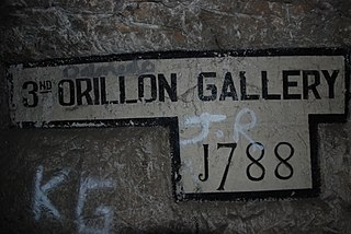
The Orillon Batteries were artillery batteries in the British Overseas Territory of Gibraltar. The batteries were three-storey gun positions within a natural fault in the Rock of Gibraltar.

Lathbury Barracks was a military barracks in the British Overseas Territory of Gibraltar that is currently used by civilians. It is located in the southern part of the Rock, south of Spur Battery on Windmill Hill. The last United Kingdom regiment based here was the 3rd Battalion Royal Green Jackets who handed it over to the local Royal Gibraltar Regiment and it is now owned by the Government of Gibraltar.

The Gibraltar peninsula, located at the far southern end of Iberia, has great strategic importance as a result of its position by the Strait of Gibraltar where the Mediterranean Sea meets the Atlantic Ocean. It has repeatedly been contested between European and North African powers and has endured fourteen sieges since it was first settled in the 11th century. The peninsula's occupants – Moors, Spanish, and British – have built successive layers of fortifications and defences including walls, bastions, casemates, gun batteries, magazines, tunnels and galleries. At their peak in 1865, the fortifications housed around 681 guns mounted in 110 batteries and positions, guarding all land and sea approaches to Gibraltar. The fortifications continued to be in military use until as late as the 1970s and by the time tunnelling ceased in the late 1960s, over 34 miles (55 km) of galleries had been dug in an area of only 2.6 square miles (6.7 km2).

The Great North Road is a large road tunnel in the British Overseas Territory of Gibraltar. It was constructed by the British military during World War II inside the Rock of Gibraltar and remains property of the Ministry of Defence to this day. The road allowed lorries to travel from the north to the south of Gibraltar entirely within the Rock. The tunnel still contains the remains of World War II buildings such as Nissen huts, kitchens, offices as well as a generating station and period anti-submarine nets.

The King's Lines are a walled rock-cut trench on the lower slopes of the north-west face of the Rock of Gibraltar. Forming part of the Northern Defences of the fortifications of Gibraltar, they were originally created some time during the periods when Gibraltar was under the control of the Moors or Spanish. They are depicted in a 1627 map by Don Luis Bravo de Acuña, which shows their parapet following a tenaille trace. The lines seem to have been altered subsequently, as maps from the start of the 18th century show a more erratic course leading from the Landport, Gibraltar's main land entrance, to the Round Tower, a fortification at their western end. A 1704 map by Johannes Kip calls the Lines the "Communication Line of the Round Tower".

The tunnels of Gibraltar were constructed over the course of nearly 200 years, principally by the British Army. Within a land area of only 2.6 square miles (6.7 km2), Gibraltar has around 34 miles (55 km) of tunnels, nearly twice the length of its entire road network. The first tunnels, excavated in the late 18th century, served as communication passages between artillery positions and housed guns within embrasures cut into the North Face of the Rock. More tunnels were constructed in the 19th century to allow easier access to remote areas of Gibraltar and accommodate stores and reservoirs to deliver the water supply of Gibraltar.


