| Douglas Cave | |
|---|---|
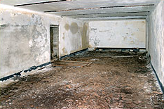
 inside the cave | |
 Map showing location in Gibraltar. | |
| Coordinates | 36°07′39.6″N5°20′42.5″W / 36.127667°N 5.345139°W |
Douglas Cave is a cave in the British Overseas Territory of Gibraltar. [1]
| Douglas Cave | |
|---|---|
| inside the cave | |
| Map showing location in Gibraltar. | |
| Coordinates | 36°07′39.6″N5°20′42.5″W / 36.127667°N 5.345139°W |
Douglas Cave is a cave in the British Overseas Territory of Gibraltar. [1]

Douglas Cave is at the bottom of Douglas Path which runs north–south along the top ridge of the Rock of Gibraltar on the road leading up to O'Hara's Battery, [2] all within the Upper Rock Nature Reserve.
First occupied during the Great Siege of Gibraltar (1779-1783). [3] Re-occupied in 1940, the cave is, unusually, inside a brick building and contains a single stone seat and the remains of a simple plaque. The reason for this construction is unknown, although some upper rock camping experts believe it was used to store a high-powered searchlight during WWII. [4]

Llanito or Yanito is a form of Andalusian Spanish heavily laced with words from English and other languages, such as Ligurian; it is spoken in the British overseas territory of Gibraltar. It is commonly marked by a great deal of code switching between Andalusian Spanish and British English and by the use of Anglicisms and loanwords from other Mediterranean languages and dialects.
The Rock of Gibraltar is a monolithic limestone mountain 426 m (1,398 ft) high dominating the western entrance to the Mediterranean Sea. It is situated near the end of a narrow 9 kilometres (5.6 mi) long promontory stretching due south into the Mediterranean Sea and is located within the British territory of Gibraltar, and is 27 km north-east of Tarifa, Spain, the southwestern tip of Europe on the Iberian Peninsula. The rock serves as an impregnable fortress and contains a labyrinthine network of man-made tunnels known as the Tunnels of Gibraltar. Most of the Rock's upper area comprises a nature reserve which is home to about 300 Barbary macaques. It is a major tourist attraction.

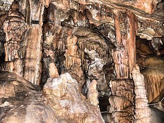
St. Michael's Cave or Old St. Michael's Cave is the name given to a network of limestone caves located within the Upper Rock Nature Reserve in the British Overseas Territory of Gibraltar, at a height of over 300 metres (980 ft) above sea level. According to Alonso Hernández del Portillo, the first historian of Gibraltar, its name is derived from a similar grotto in Monte Gargano near the Sanctuary of Monte Sant'Angelo in Apulia, Italy, where the archangel Michael is said to have appeared.

Capital punishment in Gibraltar included public execution in the nineteenth century until 1864. The last sentence of death was passed in 1952. Under British law, capital punishment was almost abolished in 1965, in line with British practice. It was entirely abolished in 2002 along with all other British Overseas Territories.

The Gibraltar Nature Reserve is a protected nature reserve in the British Overseas Territory of Gibraltar that covers over 40% of the territory's land area. It was established as the Upper Rock Nature Reserve in 1993 under the International Union for Conservation of Nature's category Ia and was last extended in 2013. It is known for its semi-wild population of Barbary macaques, and is an important resting point for migrating birds.

Lord Airey's Battery is an artillery battery in the British Overseas Territory of Gibraltar. It is located near the southern end of the Upper Rock Nature Reserve, just north of O'Hara's Battery. It was named after the Governor of Gibraltar, General Sir Richard Airey. Construction of the battery was completed in 1891. The first gun mounted on the battery was a 6-inch breech loading gun, which was replaced with a 9.2-inch Mark X BL gun by 1900. The gun at the battery was last fired in the 1970s. In 1997, it was discovered that Lord Airey's Shelter, adjacent to Lord Airey's Battery, was the site chosen for a covert World War II operation that entailed construction of a cave complex in the Rock of Gibraltar, to serve as an observation post. The battery is listed with the Gibraltar Heritage Trust.
Operation Tracer was a secret Second World War Royal Navy military operation in Gibraltar, a British Overseas Territory and military base. The impetus for the stay-behind plan was the 1940 scheme by Germany to capture Gibraltar, code-named Operation Felix. Operation Tracer was the brainchild of Rear Admiral John Henry Godfrey, the Director of the Naval Intelligence Division of the Admiralty.

Lord Airey's Shelter is a subterranean military shelter in the British Overseas Territory of Gibraltar. It is located near the southern end of the Upper Rock Nature Reserve, adjacent to Lord Airey's Battery. It was named after the Governor of Gibraltar, General Sir Richard Airey. The tunnel system for the shelter was chosen as the site for the highly classified, Second World War military operation known as Operation Tracer.

Martin's Cave is a cave in the British Overseas Territory of Gibraltar. It opens on the eastern cliffs of the Rock of Gibraltar, below its summit at O'Hara's Battery. It is an ancient sea cave, though it is now located over 700 feet (210 m) above the shore of the Mediterranean Sea. It is only accessible because Martin's Path was constructed.
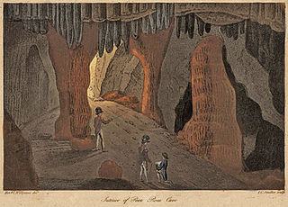
Poca Roca Cave is a cave in the British Overseas Territory of Gibraltar.
Fig Tree Cave is a cave in the British Overseas Territory of Gibraltar. It is located on the eastern cliffs of the Rock of Gibraltar, not far from Martin's Cave within the Upper Rock Nature Reserve. It is listed in the Heritage and Antiquities Act 2018 by the Government of Gibraltar.
New St. Michael's Cave, also known as Lower St. Michael's Cave, is a cave system in the British Overseas Territory of Gibraltar. Unlike its namesake, St. Michael's Cave (proper), which has been known for over 2,000 years, this cave was discovered as recently as World War II.

Mediterranean Cave is a cave in the British Overseas Territory of Gibraltar. The cave also has pillboxes and a fallout shelter nearby, these all being mentioned in the government's Heritage and Antiquities Act 2018.

Wilson's Cave is a cave in the British Overseas Territory of Gibraltar.

Star Chamber Cave is a limestone cave in the British Overseas Territory of Gibraltar. In the 1780s the cave became the centre of tunnels known as the Lower Galleries of the Northern Defences. In 1941 this cave was still in military use as the King's Regiment Battalion Headquarters

Hayne's Cave Battery is the remains of two gun positions that made up an artillery battery on the west side of the British Overseas Territory of Gibraltar at Hayne's Cave. Gun emplacements can still be visited at this cave.

King's Lines Battery is an artillery battery in the British Overseas Territory of Gibraltar. It was originally built along the access path up to the Gate of Granada.
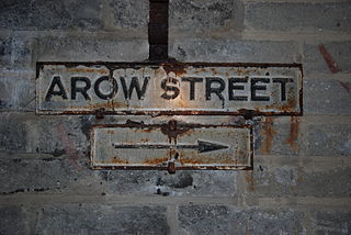
AROW Street is a tunnel in Gibraltar that was excavated in 1942. The tunnel, like Gibraltar's Great North Road, was large enough to take Army ammunition trucks.

Mediterranean Steps is a path and nature trail in the British Overseas Territory of Gibraltar. One of the footpaths of Gibraltar, the path is located entirely within the Upper Rock Nature Reserve and was built by the British military but is now used by civilians as a pedestrian route linking Martin's Path to Lord Airey's Battery near the summit of Rock of Gibraltar. The path offers views over the Strait of Gibraltar, Windmill Hill, Europa Point, the Great Sand Dune, Gibraltar's east side beaches, the Mediterranean Sea and the Spanish Costa del Sol.
The footpaths of Gibraltar provide access to key areas of the Upper Rock Nature Reserve, a refuge for hundreds of species of flora and fauna which in some cases are found nowhere else in Europe. The reserve occupies the upper part of the Rock of Gibraltar, a long and narrow mountain that rises to a maximum height of 424 metres (1,391 ft) above sea level, and constitutes around 40 per cent of Gibraltar's total land area. The unusual geology of the Rock of Gibraltar – a limestone peak adjoining a sandstone hinterland – provides a habitat for plants and animals, such as the Gibraltar candytuft and Barbary partridge, which are found nowhere else in mainland Europe. For many years, the Upper Rock was reserved exclusively for military use; it was fenced off for military purposes, but was decommissioned and converted into a nature reserve in 1993.
| | This Gibraltar location article is a stub. You can help Wikipedia by expanding it. |