
Alibag, also known as Alibaug, is a coastal city and a municipal council in Raigad district of Maharashtra, India. It is the headquarters of the Raigad district and is south of the city of Mumbai. Alibag is part of the Mumbai Metropolitan Region and is situated at a distance of about 96 km from Mumbai and 143 km from Pune. Alibag is a holy place for Goddess Shree Padmakshi Renuka. She is also known as goddess of Konkan.

Ganpatipule is a coastal town in Ratnagiri district of Maharashtra. Due to its Ganpati mandir the town is popular Hindu pilgrimage and tourists destination.
Sindhudurg district is an administrative district of the Konkan division in India, which was carved out of the erstwhile Ratnagiri district. The district headquarters are located at Oros. The district occupies an area of approximately 5,207 km2 and has a population of 849,651, of which 12.59% were urban. As of 2011, it is the least populous district of Maharashtra.
Pural is a town in Devgad Taluka in Sindhudurg district of the state of Maharashtra, India. It is a small village on the west coast of Maharashtra.
Malvan is a town and taluka in Sindhudurg District, the southernmost district of Maharashtra State, India, well known for the historically important Sindhudurg Fort. Malvan taluka consists of villages such as Angane Wadi, Masure, Achra, Khalchi Devli, Jamdul, Juva, Pankhol, Talasheel and Sarjekot. The main occupation here is fishing and agriculture. The staple diet of the local people is fish curry and rice. The town produces Alphonso mangoes and is also known for sweets such as Malvani Khaja made from gram-besan flour and coated jaggery as well as Malvani Ladoos. Other sweets that attract tourists are Konkani Meva, Aambawadi, Fanaspoli, Kajuwadi, and Naralachya Wadya.
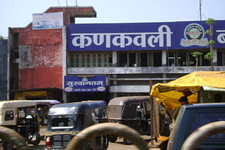
Kankavli is a city in Sindhudurg district in the Indian state of Maharashtra. It is an important city due to its central location in the Sindhudurg district. All talukas are at an equal distance from Kankavli city. There is a temple of Shri Bhalchandra Maharaj and Swyambhu Ravalnath. The Kankavli city is situated in between two west flowing rivers which carry roaring gushing waters on their rockbed to Arabian sea in monsoon. It is a culturally, educationally and socially rich and vibrant major city. A veteran Gandhian Shri Appasaheb Patwardhan founded Gopuri Ashram near Kankavli city with principles of Swadeshi, Swatchhata, Swawlamban and Sarvodaya in 1948. Kankavli is equally located from Kolhapur and Ratnagiri. This is one of the important railway stations on Konkan railway route and major towns on NH 66.

Devgad is a taluka in Sindhudurg district of Maharashtra, India consisting of 98 villages. It is located on the Arabian Sea in the coastal Konkan region of Maharashtra, south of Mumbai. Devgad is known globally for its exports of locally grown Alphonso mangoes.

Wani is a 3rd largest city in Yavatmal district in the Indian state of Maharashtra.

Kalamboli is one of the nodes of Navi Mumbai in Raigad District. It is a transportation hub, being situated at the junction of the Sion-Panvel Highway, NH 48, Panvel By-Pass, NH 66 and Mumbai-Pune Expressway and is among the biggest iron and steel delivery centers in India. The township, like the rest of Navi Mumbai, is divided into sectors, which are further divided into plots. The residential and commercial areas of Kalamboli are divided by the NH 4 highway. Roadpali, a region to the north of Kalamboli, is developing at a faster rate than the latter with many residential projects coming up due to availability of land. Roadpali is located along the Taloja Link Road. Kalamboli also houses the Navi Mumbai Police Headquarters. CIDCO is the nodal administrative body for Kalamboli node. Kalamboli also has a Sewage Water Treatment Plant owned by CIDCO. Kalamboli is now governed by Panvel Municipal Corporation (PMC). The terminal of Mumbai-Pune Expressway is at Kalamboli. It also has Navi Mumbai's largest marble market alongside the Sion Panvel Highway.
Shirol is a historic place. In a great war between Chhatrapati Shivaji Maharaj and the Mughal Empire, the Mughals were defeated and the heads of Mughal soldiers were hanged at the main gate of city. So the name Shirol: Shir (heads) + ol (row).

Anjarle is a village in the Dapoli taluka of Ratnagiri district in the Maharashtra state of India. It is a small port located near the mouth of Jog river, about 4 mi (6.4 km) south of Aade and 2 mi (3.2 km) north of Suvarnadurga. The nearest railway station is Khed, 31 mi (50 km) to the southeast.

Asoli is a small village in Taluka Vengurla and district Sindhudurg of Maharashtra, India.

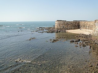
Vijaydurg is a seaport 485 km from Mumbai on India's West Coast. It boasts a safe harbour with average depths in excess of 100 feet.
Devrukh is a town in the tehsil of Sangameshwar in the Ratnagiri district of the Indian state of Maharashtra. It is headquarters for the Sangameshwar tehsil and a part of the Konkan region. The town enjoys salubrious climate, and the majority population is involved in agriculture. Summers are warm and winters are not very chilly. Every year Devrukh experiences heavy monsoon. Rice, cashew and alphonso (hapus) mangoes are the major crops in Devrukh.
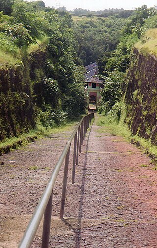
Shri Dev Rameshwar Temple is located in village Rameshwar Wadi in Devgad taluka of Sindhudurg District, Maharashtra, India. This temple is dedicated to the Hindu deity Shiva. It is a historic temple built in 16th century. Its chief interest is the approach about 250 yards long, cut through rock fifty feet deep. The idol, a four-armed figure seated on a bull, is of solid silver said to weigh a hundred kilograms and is in good condition at present.
Rameshwar also known as Rameshwar Wadi is a small town located on the coast of Sindhudurg District of Maharashtra on the west coast of India. A very old Shri Dev Rameshwar Temple is located in this town which is dedicated to the Hindu deity Shiva.
Pujare, also known as Pujar, Pujara or Pujari, traditionally belonged to the priestly class of the Maratha community. They are the original inhabitants of Rameshwar in Devgad Taluka of Sindhudurg District in Maharashtra, India.
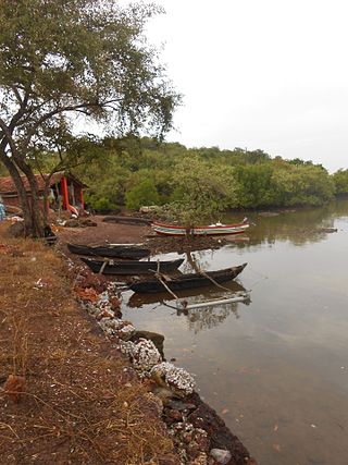
Rameshwar Dockyard also known as Rameshwar Godi (Marathi) is a small tidal dockyard located on the west bank of Waghotan River of Sindhudurg District of Maharashtra state on the west coast of India. It is a naval dockyard built by the Maratha Admiral Kanhoji Angre about 1.5 km from Vijaydurg Fort, used mainly for repair and maintenance of ships of the Maratha Navy. The dockyard currently lies on the outskirts of a small Christian Settlement and is used only for the purpose of fishing.

Shri Aday Durgay Temple is located near village Rameshwar in Devgad taluka of Sindhudurg District, Maharashtra, India. This temple is dedicated to two Hindu goddesses Aday and Durgay. It is a historic temple that was built even before the 15th century, dedicated to the Clan Goddess or Kuladevata of the Pujare.

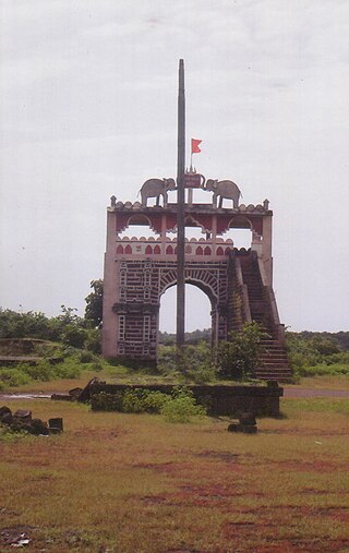
Vijaydurg Port is a natural harbour on the west coast of the district of Sindhudurg in Maharashtra, India. The port is situated midway between Malvan and Ratnagiri at the mouth of the Vijaydurg creek in Devgad taluka. Its coastal jurisdiction extends 10 km north up to the Jaitapur lighthouse. Goods weighing about 200 tons are generally loaded or unloaded at the port daily. The cargo brought by sea is transported by creek up to Kharepatan which is 26 miles up from Vijayadurg.

