Glacial erratic boulders of Island County, Washington

Last updated
Map all coordinates using: OpenStreetMap
Locations of glacial erratics in Island County. Glacial erratic boulders in Island County.png
Locations of glacial erratics in Island County.

Glacial erratic boulders in Island County are a remnant of the Pleistocene glaciation that created Puget Sound and transformed the surfaces of what are now Island County's main landmasses: Whidbey Island and Camano Island. South of Deception Pass, the two islands' surfaces and beaches are completely composed of glacial till. [1] [2] :5 Abundant glacial erratic boulders lie on the islands, their beaches, and under the near-shore waters. [3] [4]

Contents

List of boulders

Big Rock, once known as the Rock of Ages, is a 30-foot (9.1 m) high greenstone erratic and a landmark on Main Street in Coupeville, at one time considered for a city conservation easement. [5] [6] [7]

48°12′38″N122°41′14″W / 48.21056°N 122.68722°W / 48.21056; -122.68722 (Big Rock (Coupeville))

No image.png
Camano Island State Park erratic is on the south cliff trail in Camano Island State Park, overlooking Saratoga Passage. [8]

48°07′43″N122°29′59″W / 48.12861°N 122.49972°W / 48.12861; -122.49972 (Camano Island State Park erratic)

No image.png
Chuckanut erratic is a 10-foot (3.0 m) tall Chuckanut Formation sandstone boulder on the beach below Double Bluff. [9]

47°58′30″N122°31′07″W / 47.97500°N 122.51861°W / 47.97500; -122.51861 (Chuckanut erratic)

No image.png
The Clinton erratic is a greenstone boulder with north-south glacial striations, at the corner of Conrad St and Berg Road above the ferry terminal in the town of Clinton. The rock and Coupeville's Big Rock were used to calibrate 36Cl radiometric dating due to the well established date they were deposited and began to receive cosmic ray bombardment. [10] [11] [12]

47°58′23.7″N122°21′9.36″W / 47.973250°N 122.3526000°W / 47.973250; -122.3526000 (Clinton erratic)

No image.png
Footprint Rock is a boulder near Smugglers Cove on Whidbey Island's west side. The rock, high in the intertidal zone, gets its name from a "footprint like impression". [4]

48°3′57.96″N122°36′19.8″W / 48.0661000°N 122.605500°W / 48.0661000; -122.605500 (Footprint Rock)

No image.png
The Holmes Harbor erratic is on the eastern shore of Holmes Harbor, and is somewhat taller than a man. [13]

48°04′52″N122°31′01″W / 48.08111°N 122.51694°W / 48.08111; -122.51694 (Holmes Harbor erratic)

No image.png
Klootchman Rock (also spelled Kloochman) is metamorphic rock boulder with white veins. The 35-foot (11 m) [14] tall boulder topped with grass, and its broken shards sit at the base of Blowers Bluff between Penn Cove and Oak Harbor. [15] [16] The rock has a National Geodetic Survey control station at its highest point. [14] There is a submerged feature (bar) also called Klootchman Rock about 100 meters offshore. [17]

48°15′00″N122°39′14″W / 48.25000°N 122.65389°W / 48.25000; -122.65389

No image.png
Scatchet Head erratics are on the beach below bluffs at the southwest point of Whidbey Island. [18]

47°54′51.48″N122°25′52.32″W / 47.9143000°N 122.4312000°W / 47.9143000; -122.4312000 (Scatchet Head)

No image.png
Waterman Rock is a house-sized greenschist erratic with a circumference of 155 feet (47 m) and height of 38 feet (12 m) [9] to 40 feet (12 m) or greater [19] [2] :5 in Saratoga Woods Preserve near Langley. [6] [20] [21] It may be the second largest erratic in Washington State, after the Lake Stevens Monster. [9] The property including the rock was acquired in 2002 [2] :4 or 2005 [19] for conservation.

48°03′38″N122°27′47″W / 48.06056°N 122.46306°W / 48.06056; -122.46306 (Waterman Rock)

Waterman Rock east side with yardstick.JPG

Related Research Articles

<span class="mw-page-title-main">Puget Sound</span> Deep water sound of the Salish Sea in northwestern Washington, United States

Puget Sound is a sound of the Pacific Northwest, an inlet of the Pacific Ocean, and part of the Salish Sea. It is located along the northwestern coast of the U.S. state of Washington. It is a complex estuarine system of interconnected marine waterways and basins, with one major and two minor connections to the open Pacific Ocean via the Strait of Juan de Fuca—Admiralty Inlet being the major connection and Deception Pass and Swinomish Channel being the minor.

<span class="mw-page-title-main">Whidbey Island</span> Island in Puget Sound in Washington, United States

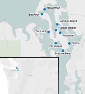
Whidbey Island is the largest of the islands composing Island County, Washington, in the United States, and the largest island in Washington state. Whidbey is about 30 miles (48 km) north of Seattle, and lies between the Olympic Peninsula and the I-5 corridor of western Washington. The island forms the northern boundary of Puget Sound. It is home to Naval Air Station Whidbey Island. The state parks and natural forests are home to numerous old growth trees.

<span class="mw-page-title-main">Island County, Washington</span> County in Washington, United States

Island County is a county located in the U.S. state of Washington. As of the 2020 census, its population was 86,857. Its county seat is Coupeville, while its largest city is Oak Harbor.

<span class="mw-page-title-main">Camano Island</span> CDP in Washington, United States

Camano Island is a large island in Possession Sound, a section of Puget Sound. It is part of Island County, Washington, and is located between Whidbey Island and the mainland by the Saratoga Passage to the west and Port Susan and Davis Slough to the east. The island has one road connection to the mainland, via State Route 532 over the Camano Gateway Bridge at the northeast end of the island, connecting to the city of Stanwood.

<span class="mw-page-title-main">Glacial erratic</span> Piece of rock that has been moved by a glacier

A glacial erratic is glacially deposited rock differing from the type of rock native to the area in which it rests. Erratics, which take their name from the Latin word errare, are carried by glacial ice, often over distances of hundreds of kilometres. Erratics can range in size from pebbles to large boulders such as Big Rock in Alberta.

<span class="mw-page-title-main">Channeled Scablands</span> Landscape in eastern Washington state scoured by cataclysmic floods during the Pleistocene epoch

The Channeled Scablands are a relatively barren and soil-free region of interconnected relict and dry flood channels, coulees and cataracts eroded into Palouse loess and the typically flat-lying basalt flows that remain after cataclysmic floods within the southeastern part of Washington state. The Channeled Scablands were scoured by more than 40 cataclysmic floods during the Last Glacial Maximum and innumerable older cataclysmic floods over the last two million years. These floods were periodically unleashed whenever a large glacial lake broke through its ice dam and swept across eastern Washington and down the Columbia River Plateau during the Pleistocene epoch. The last of the cataclysmic floods occurred between 18,200 and 14,000 years ago.

<span class="mw-page-title-main">Double Bluff Beach</span>

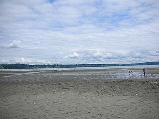
Double Bluff Beach is a beach and headland on Whidbey Island in the U.S. state of Washington. The beach tidelands themselves comprise Double Bluff State Park. The uplands and access areas are operated by Island County, Washington as Double Bluff County Park and Beach Access.

<span class="mw-page-title-main">Island Transit (Washington)</span> Local public transit operator in Island County, Washington

Island Transit is a zero-fare transit system in Island County, Washington, serving Whidbey Island and Camano Island. The system consists of fixed-route bus service, paratransit, and vanpools, and carried a total of 974,899 passengers in 2015. There is no Sunday or holiday service on Island Transit routes.

<span class="mw-page-title-main">Boulder Park</span>

Boulder Park National Natural Landmark, of Douglas County, Washington, along with the nearby McNeil Canyon Haystack Rocks and Sims Corner Eskers and Kames natural landmarks, illustrate well-preserved examples of classic Pleistocene ice stagnation landforms that are found in Washington. These landforms include numerous glacial erratics and haystack rocks that occur near and on the Withrow Moraine, which is the terminal moraine of the Okanogan ice lobe.

<span class="mw-page-title-main">Puget Sound region</span> Coastal area in U.S. state of Washington

The Puget Sound region is a coastal area of the Pacific Northwest in the U.S. state of Washington, including Puget Sound, the Puget Sound lowlands, and the surrounding region roughly west of the Cascade Range and east of the Olympic Mountains. It is characterized by a complex array of saltwater bays, islands, and peninsulas carved out by prehistoric glaciers.

<span class="mw-page-title-main">South Whidbey State Park</span>

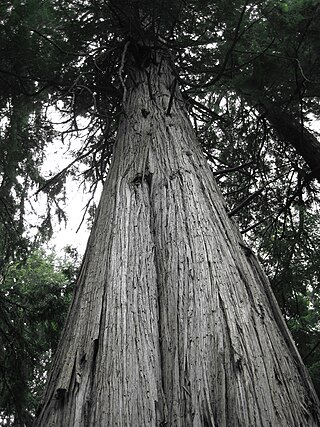
South Whidbey State Park is a public recreation area consisting of 381 acres (154 ha) of old-growth forest and tidelands with 4,500 feet (1,400 m) of shoreline on Admiralty Inlet along the west shore of Whidbey Island in Island County, Washington. The state park contains many mature specimens of western red cedar, Douglas fir, Sitka spruce, and western hemlock, some of the largest on Whidbey island, including a giant cedar over 500 years old.

<span class="mw-page-title-main">Glacial erratic boulders of King County, Washington</span>

Glacial erratic boulders of King County are large glacial erratic boulders of rock which were moved into King County, Washington by glacial action during previous ice ages.

Glacial erratic boulders of Snohomish County are large glacial erratic boulders of rock which were moved to Snohomish County, Washington by glacial action during previous ice ages.

Glacial erratic boulders of Kitsap County are large glacial erratic boulders of rock which were moved into Kitsap County, Washington by glacial action during previous ice ages.

<span class="mw-page-title-main">Lake Lawrence erratic</span> Boulder in Thurston County, Washington

The Lawrence Lake erratic is a glacial erratic boulder near Lake Lawrence in Thurston County, Washington. The boulder is about 15 feet (4.6 m) tall. Lake Lawrence itself was formed when the Vashon Glaciation created most of the topography seen in the Puget Sound region. The erratic is one of the southernmost in the Puget Sound region, near the limit of the Yelm lobe of the Vashon Glacier in the Rainier area.

Many glacial erratic boulders can be found in the Puget Sound region as far south as the Yelm area where the Puget Lobe of the glacier reached its maximum extent.

<span class="mw-page-title-main">Vashon Glaciation</span>

The Vashon Glaciation, Vashon Stadial or Vashon Stade is a local term for the most recent period of very cold climate in which during its peak, glaciers covered the entire Salish Sea as well as present day Seattle, Tacoma, Olympia and other surrounding areas in the western part of present-day Washington (state) of the United States of America. This occurred during a cold period around the world known as the last glacial period. This was the most recent cold period of the Quaternary glaciation, the time period in which the arctic ice sheets have existed. The Quaternary Glaciation is part of the Late Cenozoic Ice Age, which began 33.9 million years ago and is ongoing. It is the time period in which the Antarctic ice cap has existed.

Hills in the Puget Lowland, between the Cascades and the Olympic Mountains, including the entire Seattle metropolitan area, are generally between 350–450 feet (110–140 m) and rarely more than 500 feet (150 m) above sea level. Hills are often notable geologically and for social reasons, such as the seven hills of Seattle.

<span class="mw-page-title-main">Big Chiwaukum</span> Mountain in Washington (state), United States

Big Chiwaukum is a prominent 8,081-foot (2,463-metre) mountain summit located in Chelan County of Washington state. Big Chiwaukum is situated northeast of Frosty Pass, and within the Alpine Lakes Wilderness. Big Chiwaukum is the highest peak in the Chiwaukum Mountains, a subset of the Cascade Range. In the Wenatchee dialect, Chiwaukum means many little creeks running into one big one. Its nearest higher peak is Cashmere Mountain, 10.35 mi (16.66 km) to the south-southeast. Precipitation runoff from Big Chiwaukum drains into tributaries of the Wenatchee River.

The Camano–Whidbey ferry is a historic and proposed ferry route across Saratoga Passage on Puget Sound linking Camano Island and Whidbey Island, the titular islands of Island County, Washington.

References

  1. Tucker 2010a.
  2. 1 2 3 Whidbey Camano Land Trust; Island County (August 2010), Saratoga Management Plan (PDF), Island County Parks
  3. Haugerud 2008.
  4. 1 2 Mary Jo Adams; Judi McD. (March 7, 2008), Intertidal Monitoring - 2007, Coupeville, WA: Washington State University Island County Extension
  5. "UW professor puts Big Rock in its geologic place", South Whidbey Record, June 25, 2008, archived from the original on June 9, 2015
  6. 1 2 Burnett, Justin (January 4, 2012), "Big Rock for sale: Giant stone goes with Coupeville apartments", Whidbey News-Times , retrieved June 1, 2015
  7. Whalen, Nathan (January 27, 2012), "Coupeville Town Council unmoved by Big Rock", Whidbey News-Times , retrieved June 1, 2015
  8. Tom Barr (July 3, 1991), "Camano Island State Park Offers Wide Choice Of Facilities, Activities", The Seattle Times
  9. 1 2 3 Tucker 2010b.
  10. University of Washington Earth and Space Sciences 2010
  11. Swanson 2009, p. 7.
  12. Terry W Swanson; Marc L Caffee (January 2003), "Determination of 36Cl Production Rates Derived from the Well-Dated Deglaciation Surfaces of Whidbey and Fidalgo Islands, Washington", Quaternary Research, 59 (1): 132–134, doi:10.1006/qres.2001.2278, S2CID   131251443
  13. Western Geo Hikes 2008.
  14. 1 2 National Geodetic Survey PID TR1338, "Blowers Bluff Klootchman Rock"
  15. Hugh Shipman (May 9, 2011), "Klootchman Rock", Gravel Beach (blog)
  16. Overton, Harold L. (June 20, 2012), Quadransphere of North America
  17. U.S. Geological Survey Geographic Names Information System: Klootchman Rock
  18. R.C. Ray (1891), The Coast of British Columbia Including The Juan de Fuca Strait, Puget Sound, Vancouver and Queen Charlotte Islands, United States Navy Hydrographic Office/Government Printing Office, p. 29
  19. 1 2 "County sets Southend rockin'", South Whidbey Record, June 25, 2008, archived from the original on February 1, 2016, retrieved June 9, 2015
  20. Sheets, Bill, "Big boulder in Edmonds one of many left by long-gone glaciers", Everett Herald , archived from the original on June 21, 2015, retrieved June 1, 2015
  21. Karen Sykes (January 29, 2003), "Hike of the week: Wandering through Whidbey Island woods", The Seattle Times

Sources