Glacial erratic boulders of the Puget Sound region

Last updated

Many glacial erratic boulders (often simply called glacial erratics) can be found in the Puget Sound region as far south as the Yelm area where the Puget Lobe of the glacier reached its maximum extent.

Contents

The Pleistocene ice age glaciation of Puget Sound created many of the geographical features of the region, including Puget Sound itself, [1] and the erratics are one of the remnants of that age. [2] According to Nick Zentner of Central Washington University Department of Geological Sciences, "Canadian rocks [are] strewn all over the Puget lowland, stretching from the Olympic Peninsula clear over to the Cascade Range." [3] Erratics can be found at altitudes up to about 1,300–1,600 feet (400–490 m) in the Enumclaw area, [4] along with kames, drumlins, [5] and perhaps also the unique Mima mounds. [6] The soil of Seattle, the state's largest city, is approximately 80% glacial drift, most of which is Vashon glacial deposits (till), [7] and nearly all of the city's major named hills are characterized as drumlins (Beacon Hill, First Hill, Capitol Hill, Queen Anne Hill) or drift uplands (Magnolia, West Seattle). [3] [8] Boulders greater than 3 meters in diameter are "rare" in the Vashon till, [2] but can be found, as seen in the table below.

List of erratics

Map all coordinates using: OpenStreetMap  
Download coordinates as: KML

A few of the larger or otherwise most notable erratics can be found in this table. More erratics are noted in the area-specific lists in the navigation box.

Name and descriptionHeightCountyImage
Airport Boulder, at Martha Lake Airport Park in Martha Lake, said to be "one of the largest glacial erratic boulders in urban King, Snohomish, and Pierce counties", [9] is approximately 20 feet (6.1 m) long on its longest axis and about twice a man's height. The erratic is composed of greenstone, [10] and has long been used for bouldering (rock climbing), with at least four ascent routes. [11] [12]

47°51′53.7″N122°14′10.7″W / 47.864917°N 122.236306°W / 47.864917; -122.236306 (Airport Boulder)

12 feet (3.7 m)Snohomish Martha Lake Erratic 2015 1.jpg
Arroyo Park erratic, in Arroyo Park in Bellingham, is approximately 10 feet (3.0 m) tall and 17 by 23 feet (5.2 m × 7.0 m) in extent. It is mostly diorite with granodiorite dikes. [13] [14]

48°41′54″N122°28′45″W / 48.6983°N 122.4793°W / 48.6983; -122.4793 (Arroyo Park erratic)

10 feet (3.0 m)Whatcom
Big Rock is an 8-foot (2.4 m) tall glacial erratic in the city of Duvall. A Duvall road, a park, and several businesses are named after it. [15] [16] The rock, and two non-native sequoias adjacent to it probably planted by area pioneers, are a local landmark. [17] The erratic lies in what is said to be the smallest King County park, 20 by 70 feet (6.1 m × 21.3 m) in extent, that barely contains the rock and sequoias. [18] The two lanes of Big Rock Road used to split into a wye around the rock, until a shopping center was built nearby in the 1990s. [17] [18]

47°43.542′N121°59.189′W / 47.725700°N 121.986483°W / 47.725700; -121.986483 (Big Rock (Duvall))

8 feet (2.4 m)King Big Rock erratic in Duvall north face.JPG
Big Rock, once known as the Rock of Ages, a greenstone erratic and a landmark on Main Street in Coupeville, at one time considered for a city conservation easement [19] [20] [21]

48°12′38″N122°41′14″W / 48.21056°N 122.68722°W / 48.21056; -122.68722 (Big Rock (Coupeville))

30 feet (9.1 m)Island
Dabob Bay erratic, a non metamorphosed conglomerate erratic on the shore of Dabob Bay, possibly part of Chuckanut Formation from Whatcom County 80 miles (130 km) away. [22]

47°48′N122°48′W / 47.8°N 122.8°W / 47.8; -122.8 (Dabob Bay erratic)

Jefferson
Discovery Park beach erratics

Four or more erratics on beach below Discovery Park. Largest is 15.33 feet (4.67 m) high, 69.5 feet (21.2 m) in circumference. [23]

47°40.124′N122°25.210′W / 47.668733°N 122.420167°W / 47.668733; -122.420167 (Discovery Park beach erratics)

15.33 feet (4.67 m)King Eastern Discovery Park beach erratic, yardstick.jpg
Fort Townsend State Park erratics are two erratics in Fort Townsend State Park. One is granite, probably from the British Columbia Coast Range; the other basaltic and either from B.C. or from the Olympic Peninsula. [24]

48°04′24″N122°47′22″W / 48.07333°N 122.78944°W / 48.07333; -122.78944 (Fort Townsend State Park)

Jefferson
Four Mile Rock (also Fourmile Rock) is a round granite erratic, approximately 20 feet (6.1 m) across, in the intertidal zone below Seattle's Magnolia Bluff and 60 yards offshore. [25] It has had a navigational light placed on it and appears on nautical charts. [26]

Native Americans called the rock LE'plEpL, also written La'pub, and also called it Tele'tla (meaning "rock"). A legend says that a hero named Sta'kub could throw a giant cedar and hazel branch dragnet over the rock while standing at the beach. [27]

47°38′20″N122°24′48″W / 47.63889°N 122.41333°W / 47.63889; -122.41333 (Four Mile Rock) [28]

15 feet (4.6 m)King Fourmile Rock, Magnolia at low tide, with yardstick.JPG
Frog Rock , a Bainbridge Island landmark

47°41′46″N122°31′24″W / 47.69612°N 122.52347°W / 47.69612; -122.52347 (Frog Rock)

7.33 feet (2.23 m)Kitsap Bainbridge Island Frog Rock.jpg
Lake Lawrence erratic in the Puget Sound lowlands near Lake Lawrence in Thurston County. The southernmost glacier in this list, near the limit of the Yelm lobe of the Vashon Glacier in the Rainier (city) area. [29]

46°51′54″N122°34′45″W / 46.86507°N 122.57904°W / 46.86507; -122.57904 (Lake Lawrence erratic)

15 feet (4.6 m)Thurston Lawrence Lake erratic 1.jpg
Lake Stevens Monster near Lake Stevens. 34 by 78 feet (10 m × 24 m) and 210 feet (64 m) in circumference. Largest known erratic in Washington State as of 2011, [30] and may be largest in the United States (but not North America; see the Alberta Big Rock).

47°59.816′N122°6.954′W / 47.996933°N 122.115900°W / 47.996933; -122.115900 (Lake Stevens Monster)

34 feet (10 m)Snohomish Lake Stevens Monster 2015b.jpg
Lone Rock, the namesake landmark of the unincorporated community of Lone Rock, located on the Hood Canal tidal flat about 400 feet off shore. At least 50 feet (15 m) across. [31]

47°39′47″N122°46′12″W / 47.66297°N 122.769916°W / 47.66297; -122.769916 (Lone Rock)

50 feet (15 m)Kitsap Lone-Rock-Hood-Canal-Washington-18-Aug-2017.jpg
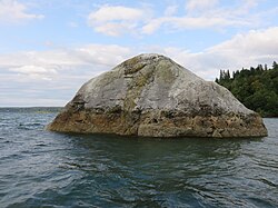
Oyster Bay erratic on the shore of Oyster Bay in Thurston County

47°6′15.5″N123°4′3.0″W / 47.104306°N 123.067500°W / 47.104306; -123.067500 (Oyster Bay erratic)

12 feet (3.7 m)Thurston Oyster Bay erratic 1.jpg
The Skystone in Bonney Lake, an andesite erratic that may have astronomical significance to the Puyallup tribe of Native Americans. It was called by an archaeastronomer "the new world Stonehenge". Height and width 4.5 by 12 feet (1.4 m × 3.7 m).

47°09′14″N122°11′41″W / 47.153807°N 122.194685°W / 47.153807; -122.194685 (Skystone)

4.5 feet (1.4 m)Pierce Skystone.jpg
Waterman Rock in Saratoga Woods Preserve near Langley [20] [32] [33]

48°03′38″N122°27′47″W / 48.06056°N 122.46306°W / 48.06056; -122.46306 (Waterman Rock)

38 feet (12 m)Island Waterman Rock east side with yardstick.JPG
Wedgwood Rock is a glacial erratic (and known to geologists as the "Wedgwood Erratic") near the neighborhood of Wedgwood in Seattle, Washington. It is 80 feet (24 m) in circumference and 19 feet (5.8 m) or 26 feet (8 m) [34] in height. Since 1970 it has been an offense punishable by a $100 fine to climb the rock. [35]

47°40′51″N122°17′50″W / 47.68084°N 122.2973°W / 47.68084; -122.2973 (Wedgwood Rock)

26 feet (8 m)King Wedgwood Rock, yardstick.JPG
White Rock, metasandstone turned white from bird guano, in the intertidal zone at the head of Hood Canal [36] [37]

47°53.593′N122°38.579′W / 47.893217°N 122.642983°W / 47.893217; -122.642983 (White Rock)

24 feet (7.3 m)Jefferson

Related Research Articles

<span class="mw-page-title-main">Puget Sound</span> Deep water sound of the Salish Sea in northwestern Washington, United States

Puget Sound is a sound of the Pacific Northwest, an inlet of the Pacific Ocean, and part of the Salish Sea. It is located along the northwestern coast of the U.S. state of Washington. It is a complex estuarine system of interconnected marine waterways and basins, with one major and two minor connections to the open Pacific Ocean via the Strait of Juan de Fuca—Admiralty Inlet being the major connection and Deception Pass and Swinomish Channel being the minor.

Chief Seattle Council is the local council governing the scouting activities of the Boy Scouts of America in a large part of the Puget Sound and Seattle area, including almost all of the Olympic Peninsula.

<span class="mw-page-title-main">Seattle metropolitan area</span> Metropolitan statistical area in Washington, United States

The Seattle metropolitan area is an urban conglomeration in the U.S. state of Washington that comprises Seattle, its surrounding satellites and suburbs. It contains the three most populous counties in the state—King, Pierce, and Snohomish — and is considered part of the greater Puget Sound region. The United States Census Bureau defines the metropolitan area as the Seattle–Tacoma–Bellevue, WA metropolitan statistical area. With an estimated population of 4,102,400 as of 2022, it is the 15th largest metropolitan statistical area (MSA) in the United States and is home to over half of Washington's population.

<span class="mw-page-title-main">Glacial erratic</span> Piece of rock that has been moved by a glacier

A glacial erratic is glacially deposited rock differing from the type of rock native to the area in which it rests. Erratics, which take their name from the Latin word errare, are carried by glacial ice, often over distances of hundreds of kilometres. Erratics can range in size from pebbles to large boulders such as Big Rock in Alberta.

<span class="mw-page-title-main">Seattle Fault</span> Zone of multiple thrust faults that passes through Seattle

The Seattle Fault is a zone of multiple shallow east–west thrust faults that cross the Puget Sound Lowland and through Seattle in the vicinity of Interstate Highway 90. The Seattle Fault was first recognized as a significant seismic hazard in 1992, when a set of reports showed that about 1,100 years ago it was the scene of a major earthquake of about magnitude 7 – an event that entered Native American oral legend. Extensive research has since shown the Seattle Fault to be part of a regional system of faults.

<span class="mw-page-title-main">Wedgwood Rock</span> Large rock in North Seattle

Wedgwood Rock is a glacial erratic near the neighborhood of Wedgwood in Seattle, Washington. Its mineral composition matches that of Mount Erie, on Fidalgo Island in Skagit County, Washington, 55 mi (89 km) north. Prior to the establishment of the Wedgwood neighborhood, the erratic was known first as Lone Rock and later simply as Big Rock. Transported to its site by the Puget Lobe of the Cordilleran Ice Sheet during the Vashon Glaciation more than 14,000 years ago, it was a landmark for Native Americans in what was once a dense forest. Today, the rock sits in a residential neighborhood on 28th Avenue NE, near NE 72nd Street, still surrounded by trees and brush, and kept clear by local residents.

The term seven hills of Seattle refers unofficially to the hills the U.S. city was built on and around, though there is no consensus on exactly which hills it refers to. The term has been used to refer to several other cities, most notably Rome and Constantinople.

<span class="mw-page-title-main">Double Bluff Beach</span>

Double Bluff Beach is a beach and headland on Whidbey Island in the U.S. state of Washington. The beach tidelands themselves comprise Double Bluff State Park. The uplands and access areas are operated by Island County, Washington as Double Bluff County Park and Beach Access.

<span class="mw-page-title-main">Withrow Moraine and Jameson Lake Drumlin Field</span>

The Withrow Moraine and Jameson Lake Drumlin Field is a National Park Service–designated privately owned National Natural Landmark located in Douglas County, Washington state, United States. Withrow Moraine is the only Ice Age terminal moraine on the Waterville Plateau section of the Columbia Plateau. The drumlin field includes excellent examples of glacially-formed elongated hills.

<span class="mw-page-title-main">Boulder Park</span>

Boulder Park National Natural Landmark, of Douglas County, Washington, along with the nearby McNeil Canyon Haystack Rocks and Sims Corner Eskers and Kames natural landmarks, illustrate well-preserved examples of classic Pleistocene ice stagnation landforms that are found in Washington. These landforms include numerous glacial erratics and haystack rocks that occur near and on the Withrow Moraine, which is the terminal moraine of the Okanogan ice lobe.

<span class="mw-page-title-main">Puget Sound region</span> Region around Puget Sound in Washington

The Puget Sound region is a coastal area of the Pacific Northwest in the U.S. state of Washington, including Puget Sound, the Puget Sound lowlands, and the surrounding region roughly west of the Cascade Range and east of the Olympic Mountains. It is characterized by a complex array of saltwater bays, islands, and peninsulas carved out by prehistoric glaciers.

<span class="mw-page-title-main">Puget Sound faults</span> Seismic faults in Washington State

The Puget Sound faults under the heavily populated Puget Sound region of Washington state form a regional complex of interrelated seismogenic (earthquake-causing) geologic faults. These include the:

<span class="mw-page-title-main">Glacial erratic boulders of King County, Washington</span> List article

Glacial erratic boulders of King County are large glacial erratic boulders of rock which were moved into King County, Washington by glacial action during previous ice ages.

Glacial erratic boulders of Snohomish County are large glacial erratic boulders of rock which were moved to Snohomish County, Washington by glacial action during previous ice ages.

<span class="mw-page-title-main">Haleets</span> Boulder on Bainbridge Island, Washington

Haleets is a sandstone glacial erratic boulder with inscribed petroglyphs on Bainbridge Island, Washington. The Native American Suquamish Tribe claims the rock, on a public beach at Agate Point on the shore of Agate Passage, as part of their heritage. The exact date the petroglyphs were carved is unknown but is estimated to be around 1000 BCE to 400 or 500 CE, the latest date being when labrets were no longer used by Coast Salish peoples.

<span class="mw-page-title-main">Lake Lawrence erratic</span> Boulder in Thurston County, Washington

The Lawrence Lake erratic is a glacial erratic boulder near Lake Lawrence in Thurston County, Washington. The boulder is about 15 feet (4.6 m) tall. Lake Lawrence itself was formed when the Vashon Glaciation created most of the topography seen in the Puget Sound region. The erratic is one of the southernmost in the Puget Sound region, near the limit of the Yelm lobe of the Vashon Glacier in the Rainier area.

<span class="mw-page-title-main">Glacial erratic boulders of Island County, Washington</span>

Glacial erratic boulders in Island County are a remnant of the Pleistocene glaciation that created Puget Sound and transformed the surfaces of what are now Island County's main landmasses: Whidbey Island and Camano Island. South of Deception Pass, the two islands' surfaces and beaches are completely composed of glacial till. Abundant glacial erratic boulders lie on the islands, their beaches, and under the near-shore waters.

Martha Lake Airport Park is a county park located in Martha Lake, Snohomish County, Washington. It was originally a private-use airport known as the Martha Lake Airport that was closed in the late 1990s and sold to the county in 2000. The 28.76-acre (11.64 ha) park was opened in 2010 and features athletic fields for soccer and softball and a skate park. A large glacial erratic on the property, one of several in the county, is used for bouldering.

<span class="mw-page-title-main">Vashon Glaciation</span>

The Vashon Glaciation, Vashon Stadial or Vashon Stade is a local term for the most recent period of very cold climate in which during its peak, glaciers covered the entire Salish Sea as well as present day Seattle, Tacoma, Olympia and other surrounding areas in the western part of present-day Washington (state) of the United States of America. This occurred during a cold period around the world known as the last glacial period. This was the most recent cold period of the Quaternary glaciation, the time period in which the arctic ice sheets have existed. The Quaternary Glaciation is part of the Late Cenozoic Ice Age, which began 33.9 million years ago and is ongoing. It is the time period in which the Antarctic ice cap has existed.

Hills in the Puget Lowland, between the Cascades and the Olympic Mountains, including the entire Seattle metropolitan area, are generally between 350–450 feet (110–140 m) and rarely more than 500 feet (150 m) above sea level. Hills are often notable geologically and for social reasons, such as the seven hills of Seattle.

References

  1. Troost & Booth 2008, p. 12 "During the period that the Vashon-age ice sheet covered the region, a tremendous volume of pressurized water was carried by subglacial streams and was responsible for carving the deep troughs of the modern Puget Sound."
  2. 1 2 Booth, Troost & Shimel 2008.
  3. 1 2 Geology of Seattle and the Puget Sound on YouTube, narrated by Nick Zentner (Central Washington University Department of Geological Sciences). Uploaded March 2, 2015 by Hugefloods.com (Nick Zentner and Tom Foster: Discover the Ice Age Floods).
  4. Bretz 1913, p. 34.
  5. Goldstein 1994.
  6. Pailthorp, Bellamy, "Mima Mounds continue to mystify scientists", KPLU Wonders, KPLU
  7. Troost & Booth 2008, p. 2.
  8. Troost & Booth 2008, p. 5.
  9. Martha Lake Airport Park, Snohomish County, Washington, retrieved 2015-04-05
  10. David C. McConnell (March 8, 2012), History of Martha Lake Airport Community Park and "Big Rock", Snohomish County Parks Department
  11. Snohomish County Parks e-Newsletter, Snohomish County, Washington, April 2012
  12. Jacob Smith (October 31, 2012). "Airport Boulder". SummitPost.org.
  13. Dave Tucker (April 12, 2011), Dave Tucker (ed.), "Bellingham area glacial erratics: The Arroyo Park erratic", Northwest Geology Field Trips
  14. Hutton, Jane (December 2012), "Distributed Evidence: Mapping Named Erratics", in Ellsworth, Elizabeth; Kruse, Jamie (eds.), Making the Geologic Now;Responses to Material Conditions of Contemporary Life, pp. 99–103, ISBN   978-0-9882340-2-4
  15. Dave Tucker (December 12, 2009), Dave Tucker (ed.), "'Big Rock' (another one) in Duvall, Washington", Northwest Geology Field Trips
  16. Duvall Visitors Guide (PDF), Duvall Chamber of Commerce, 2015
  17. 1 2 Louis T. Corsaletti (March 10, 1998), "Big Rock, Big Trees, Little Park -- New Safeway Being Built Near Tiny Duvall Landmark", The Seattle Times
  18. 1 2 "Washington Rock is County Park", Reading Eagle , Reading, Pennsylvania, p. 42, May 15, 1977
  19. "UW professor puts Big Rock in its geologic place", South Whidbey Record, June 25, 2008, archived from the original on June 9, 2015
  20. 1 2 Burnett, Justin (January 4, 2012), "Big Rock for sale: Giant stone goes with Coupeville apartments", Whidbey News-Times , retrieved June 1, 2015
  21. Whalen, Nathan (January 27, 2012), "Coupeville Town Council unmoved by Big Rock", Whidbey News-Times , retrieved June 1, 2015
  22. McShane, Dan (July 18, 2011), "Conglomerate Erratic and Link to Northwest Geology Field Trips Write Up of a Huge Erratic", Reading the Washington Landscape
  23. "Beach Erratics at Discovery Park, Seattle". 27 January 2012.
  24. Leslie Aickin (January 2008), The Geology of Fort Townsend State Park (PDF), Jefferson Land Trust Geology Group, p. 1
  25. Ray 1891, p. 37.
  26. Puget Sound – Shilshole Bay to Commencement Bay (PDF) (Natucial chart), National Oceanic and Atmospheric Administration National Ocean Service, Office of Coast Survey, 2015, NOAA Chart 18474, archived from the original (PDF) on 2015-04-27, retrieved 2015-05-25
  27. Waterman 1922, p. 188.
  28. U.S. Geological Survey Geographic Names Information System: Fourmile Rock
  29. Timothy J. Walsh; Robert L. Logan (2005), Geologic Map GM-56: Geologic Map of the East Olympia 7.5-minute Quadrangle, Thurston County, Washington (PDF), Washington Department of Natural Resources
  30. Dave Tucker (July 18, 2011), "The Lake Stevens monster- largest erratic in Washington. Largest in the US?", Northwest Geology Field Trips
  31. Measured on Google Maps overhead imagery August 24, 2017.
  32. Tucker, Dave (February 11, 2010), "Whidbey Island Erratics", Northwest Geology Field Trips
  33. Sheets, Bill, "Big boulder in Edmonds one of many left by long-gone glaciers", Everett Herald , archived from the original on June 21, 2015, retrieved June 1, 2015
  34. Troost & Booth 2008.
  35. David Wilma (July 24, 2001), "Seattle Neighborhoods: Wedgwood -- Thumbnail History", HistoryLink , Seattle: History Ink
  36. Dave Tucker (January 21, 2011), Dave Tucker (ed.), "A Really Big Erratic White Rock in Jefferson County", Northwest Geology Field Trips
  37. Dave Tucker (23 April 2011), "White Rock, a large erratic at Hood Head, Hood Canal", Northwest Geology Field Trips

Works cited