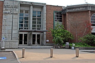
Kitsap County is located in the U.S. state of Washington. As of the 2010 census, its population was 251,133. Its county seat is Port Orchard, and its largest city is Bremerton. The county was formed out of King County and Jefferson County on January 16, 1857, and is named for Chief Kitsap of the Suquamish Tribe. Originally named Slaughter County, it was soon renamed.

Tamborine is a national park in the Gold Coast hinterland and is a part of the Scenic Rim Regional Council of South East Queensland, Australia, 45 km (28 mi) south of Brisbane.
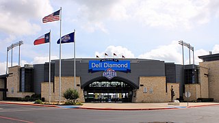
Round Rock is a city in the U.S. state of Texas, in Williamson County, which is a part of the Greater Austin metropolitan area. Its population is 99,887 as of the 2010 census.
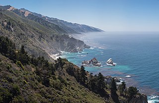
Big Sur is a rugged and mountainous section of the Central Coast of California between Carmel and San Simeon, where the Santa Lucia Mountains rise abruptly from the Pacific Ocean. It is frequently praised for its dramatic scenery. Big Sur has been called the "longest and most scenic stretch of undeveloped coastline in the contiguous United States", a sublime "national treasure that demands extraordinary procedures to protect it from development", and "one of the most beautiful coastlines anywhere in the world, an isolated stretch of road, mythic in reputation". The views, redwood forests, hiking, beaches, and other recreational opportunities have made Big Sur a popular destination for about 7 million people who live within a day's drive and visitors from across the world. It is among the top 35 tourist destinations world-wide. The region receives about the same number of visitors as Yosemite National Park, but offers only limited bus service, few restrooms, and a narrow two-lane highway that for most of its length clings to the steep coastal cliffs. North-bound traffic during the peak summer season and holiday weekends is often backed up for about 20 miles (32 km) from Big Sur Village to Carmel Highlands. Due to the large number of visitors, congestion and slow traffic between Carmel and Posts is becoming the norm.
Little Valley is a town in Cattaraugus County, New York, United States. The population was 1,740 at the 2010 census. The town is named after its local geographical setting, a relative comparison of two tributaries of the Allegheny River.

Poestenkill is a town in Rensselaer County, New York, United States. The population was 4,530 at the 2010 census. The town is southeast of Troy and is centrally located in the county.

The Kitsap Peninsula lies west of Seattle across Puget Sound, in Washington state in the Pacific Northwest. Hood Canal separates the peninsula from the Olympic Peninsula on its west side. The peninsula, a.k.a. "Kitsap", encompasses all of Kitsap County except Bainbridge and Blake Islands, as well as the northeastern part of Mason County and the northwestern part of Pierce County. The highest point on the Kitsap Peninsula is Gold Mountain. The U.S. Navy's Puget Sound Naval Shipyard, and Naval Base Kitsap are on the peninsula. Its main city is Bremerton.

Seabeck is an unincorporated community and census-designated place (CDP) in Kitsap County, Washington, United States. The population was 1,105 at the 2010 census. Seabeck is a former mill town on Hood Canal.

Hansville is an unincorporated community and census-designated place (CDP) in Kitsap County, Washington, United States. Its population was 3,091 as of the 2010 U.S. Census. The coastal community is located at the northern end of the Kitsap Peninsula and is about 16 miles (26 km) northeast of Poulsbo, the nearest city.

The Cacapon River, located in the Appalachian Mountains of West Virginia's Eastern Panhandle region, is an 81.0-mile-long (130.4 km) river known for its fishing, boating, wildlife, and scenery. As part of the Potomac River watershed, it is an American Heritage River.
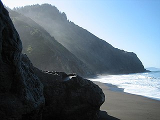
The Lost Coast is a mostly natural and undeveloped area of the California North Coast in Humboldt and Mendocino Counties, which includes the King Range. It was named the "Lost Coast" after the area experienced depopulation in the 1930s. In addition, the steepness and related geotechnical challenges of the coastal mountains made this stretch of coastline too costly for state highway or county road builders to establish routes through the area, leaving it the most undeveloped and remote portion of the California coast. Without any major highways, communities in the Lost Coast region such as Petrolia, Shelter Cove, and Whitethorn are isolated from the rest of California.
Romance is an unincorporated community in west-central White County, Arkansas, United States. The community is located approximately halfway between the town of Rose Bud to the north, and the unincorporated community of El Paso to the south. Alternately, the community is about 16 miles (26 km) northwest of Beebe, and less than 5 miles (8 km) east of Mount Vernon.

Highway 87 is a designation for four north–south state highways in Arkansas. Created during the 1926 Arkansas state highway numbering, the original alignment remains between Bradford and Pleasant Plains, though it has been revised and extended over the years. The three remaining segments are former county roads, connecting rural communities to local points of interest and other state highways. All three were added to the state highway system in 1973 during a period of system expansion. All segments are maintained by the Arkansas Department of Transportation (ArDOT).
Eglon is an unincorporated community in Kitsap County, Washington, United States. The town has a community center, a church, a cemetery, a boat launch, a beach, and a picnic area. Its Fire Protection services are provided by North Kitsap Fire and Rescue.

Hannam Vale is a small village located in a forestry and dairy farming area on the Mid North Coast, about 25 miles (40 km) North-West of Taree in New South Wales, Australia.

Highway 14 is an east–west state highway in Arkansas. The route of 227.35 miles (365.88 km) begins at Boat Dock Road near Table Rock Lake and runs east to Mississippi County Route W1020 (CR W1020) at Golden Lake. Segments of the highway are part of two Arkansas Scenic Byways: Sylamore Scenic Byway in the Ozark National Forest and the Crowley's Ridge Parkway atop Crowley's Ridge.

Anderson Canyon in the Big Sur region of California was named after pioneering homesteaders James and Peter Andersen who were the first European settlers of the area. The canyon, Anderson Creek, and Anderson Peak are south of McWay Falls and within the boundaries of Julia Pfeiffer Burns State Park.

Yakso Falls is a 70-foot (21 m) waterfall on Little River, in the Cascade Range east of Roseburg in the U.S. state of Oregon. The waterfall is about 27 miles (43 km) from the unincorporated community of Glide along Little River Road, which becomes Forest Road 27.

The Blue Hills just west of Bremerton, Washington, also called the Bremerton Hills, Bald Hills, and Wildcat Hills, consist of Gold Mountain, Green Mountain, and several informally named hills. Reaching an elevation of 1761 feet, a thousand feet above the glacial till that fills the Puget Lowland, they form a prominent landmark visible around the region. They are formed of uplifted blocks of marine basalts, the steep-walled canyons between the various summits being the fissures between the blocks. In addition to Gold Mountain and Green Mountain are several other prominent peaks unofficially named according to their elevation :


