
Puget Sound Naval Shipyard, officially Puget Sound Naval Shipyard and Intermediate Maintenance Facility, is a United States Navy shipyard covering 179 acres (0.7 km2) on Puget Sound at Bremerton, Washington in uninterrupted use since its establishment in 1891; it has also been known as Navy Yard Puget Sound, Bremerton Navy Yard, and the Bremerton Naval Complex.
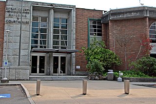
Kitsap County is a county in the U.S. state of Washington. As of the 2020 census, its population was 275,611. Its county seat is Port Orchard; its largest city is Bremerton. The county, formed out of King County and Jefferson County on January 16, 1857, is named for Chief Kitsap of the Suquamish Tribe. Originally named Slaughter County, it was soon renamed.

Bremerton is a city in Kitsap County, Washington. The population was 43,505 at the 2020 census and an estimated 44,122 in 2021, making it the largest city on the Kitsap Peninsula. Bremerton is home to Puget Sound Naval Shipyard and the Bremerton Annex of Naval Base Kitsap.

USS George Washington Carver (SSBN-656), a Benjamin Franklin class fleet ballistic missile submarine, was the second ship of the United States Navy to be named for George Washington Carver (1865–1943), an American researcher and inventor.

Vigor Shipyards is the current entity operating the former Todd Shipyards after its acquisition in 2011. Todd Shipyards was founded in 1916, which owned and operated shipyards on the West Coast of the United States, East Coast of the United States and the Gulf. Todd Shipyards were a major part of the Emergency Shipbuilding Program for World War II.
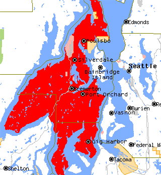
The Kitsap Peninsula lies west of Seattle across Puget Sound, in Washington state in the Pacific Northwest. Hood Canal separates the peninsula from the Olympic Peninsula on its west side. The peninsula, a.k.a. "Kitsap", encompasses all of Kitsap County except Bainbridge and Blake Islands, as well as the northeastern part of Mason County and the northwestern part of Pierce County. The highest point on the Kitsap Peninsula is Gold Mountain. The U.S. Navy's Puget Sound Naval Shipyard, and Naval Base Kitsap are on the peninsula. Its main city is Bremerton.
Naval Base Kitsap is a U.S. Navy base located on the Kitsap Peninsula in Washington state, created in 2004 by merging the former Naval Station Bremerton with Naval Submarine Base Bangor. It is the home base for the Navy’s fleet throughout West Puget Sound, provides base operating services, support for both surface ships and fleet ballistic missile and other nuclear submarines as one of the U.S. Navy's four nuclear shipyards, one of two strategic nuclear weapons facilities, and the only West Coast dry dock capable of handling a Nimitz-class aircraft carrier and the Navy's largest fuel depot. Naval Base Kitsap is the third-largest Navy base in the U.S. The base has a workforce of 15,601 active duty personnel.

USS Seahorse (SSN-669), a Sturgeon-class attack submarine, was the second submarine and third ship of the United States Navy to be named for the seahorse.

Sinclair Inlet is a shallow embayment in the western part of Puget Sound in Kitsap County, Washington, USA. It has a maximum depth of 20 meters. It is the southwestern extension of Port Orchard, and it touches the shores of three of Kitsap County's four incorporated cities: Bremerton, Bainbridge Island, and Port Orchard. It is connected to Dyes Inlet by the Port Washington Narrows and to Puget Sound by Rich Passage. It was named by United States Navy explorer Charles Wilkes for George T. Sinclair, acting master of one of his ship's crews. The Puget Sound Naval Shipyard is located on the north shore of Sinclair Inlet.

Manchester State Park is a 111-acre (45 ha) state park in Kitsap County, Washington, United States. It is situated on the east side of the Kitsap Peninsula with 3,400 feet (1,000 m) of shoreline facing Puget Sound. It was at one time a harbor defense installation for the nearby Bremerton, then a fuel supply depot and U.S. Navy fire-fighting station. The park contains a former torpedo warehouse, a mining casement, and a gun battery. Park activities include picnicking, camping, boating, fishing, hiking on 1.9 miles (3.1 km) of trails, birdwatching, volleyball, wildlife viewing, and horseshoes.

Illahee State Park is an 82-acre (33 ha) Washington state park located in the hamlet of Illahee, just north of East Bremerton, on Port Orchard Bay, part of Puget Sound. The word "Illahee" means earth or country in the Native language Chinuk Wawa. The park was established when Kitsap County donated 13 acres to the state in 1934. The park's old-growth stand is home to one of the nation's oldest Pacific yews, which has been standing for approximately 400 years. Park activities include picnicking, camping, hiking, boating, and shellfish harvesting.
The Manette Peninsula is a headland that is part of the larger Kitsap Peninsula, located on the eastern flank of the Kitsap Peninsula, in western Washington, United States.

State Route 304 (SR 304) is a state highway in Kitsap County, Washington, United States. It connects SR 3, a regional freeway, to the Puget Sound Naval Shipyard and downtown Bremerton. The designation of SR 304 continues onto the Seattle–Bremerton ferry operated by Washington State Ferries to Colman Dock in Downtown Seattle, terminating at SR 519 on Alaskan Way.

State Route 303 (SR 303) is a 9.27-mile (14.92 km) state highway in Kitsap County, located in the U.S. state of Washington. The highway connects SR 304 in Bremerton to an interchange with SR 3 in Silverdale. SR 303 crosses the Port Washington Narrows on the Warren Avenue Bridge in Bremerton and becomes a grade-separated freeway bypass of Silverdale. The route has existed as unpaved roads since the 1930s and was signed as Secondary State Highway 21B (SSH 21B) in 1937. SSH 21B connected Bremerton to Keyport and had a branch to Illahee State Park added in 1961. After the 1964 highway renumbering, SSH 21B became SR 303 from Bremerton to Keyport and SR 306 from Bremerton to Illahee State Park. SR 303 was shortened in 1971, to include SR 308, and in 1991, re-routing the highway onto the new Silverdale freeway. SR 303 also had a spur route in Bremerton that served the Manette Bridge until 1991.

The Puget Sound region is a coastal area of the Pacific Northwest in the U.S. state of Washington, including Puget Sound, the Puget Sound lowlands, and the surrounding region roughly west of the Cascade Range and east of the Olympic Mountains. It is characterized by a complex array of saltwater bays, islands, and peninsulas carved out by prehistoric glaciers.

The Seattle–Bainbridge ferry is a ferry route across Puget Sound between Seattle and Bainbridge Island, Washington. The route was called the Seattle–Winslow ferry before the city of Winslow annexed the rest of the island and changed its name. Since 1951 the only ferries employed on the route have belonged to the Washington state ferry system, currently the largest ferry system in the United States.

The U.S. National Oceanic and Atmospheric Administration (NOAA) National Status and Trends (NS&T) Mussel Watch Program is a water contaminant monitoring program that started in 1986..The program was inspired by Dr. Ed Goldberg at Scripps Institute of Oceanography, but was conceived and designed at a workshop sponsored by NOAA, held at Battelle Ocean Sciences in 1984, and led by Dr. Paul D. Boehm. It is the longest running continuous contaminant monitoring program of its kind in the United States. Mussel Watch monitors the concentration of contaminants in bivalves and sediments in the coastal waters of the U.S., including the Great Lakes, to monitor bivalve health and by extension the health of their local and regional environment.

Puget Sound Naval Shipyard is a large military-industrial complex located in Bremerton, Washington along the north shore of Sinclair Inlet, which opens to Puget Sound. This large shipyard is 1.5 miles (2.4 km) in length along the shore and over a half-mile in width at its greatest distance across. The shipyard has nearly 1,000 facilities such as shipfitters shops, repair shops, drydocks, piers, cranes, crane rails, railways, and tunnels. In addition to the industrial facilities, supporting structures include: residences for officers and enlisted personnel, recreation facilities, boiler, electrical substations, fuel tanks, medical facilities, and canteens. The historic district is just over a tenth of the entire shipyard, 189 acres of the shipyard's 1,347 acres. Its greatest significance was during the Second World War when it repaired large warships damaged in the Pacific theater. It was designated a National Historic Landmark District in 1992.

The steamship General Frisbie was a wooden two-deck passenger ship built in 1900, named after John B. Frisbie. She was designed for use as a ferry between Vallejo and San Francisco. The steamer was successful in that role and was the fastest ship on the route when she began service. Improved roads, bridges, and automobiles reduced demand for ferry service in the Bay Area, and newer ships were optimized for transporting cars, so General Frisbie was retired in the late 1920s.
Ostrich Bay is a small bay in Bremerton on the Kitsap Peninsula in the U.S. state of Washington. Approximately 1.2 miles long and 0.5 miles wide, the bay has a maximum depth of 45 feet. It is connected to Oyster Bay to the south, and Dyes Inlet to the north. On the west side of Ostrich Bay is Jackson Park, a naval housing neighborhood built on the former site of Naval Ammunition Depot Puget Sound. On the east shore of the bay is Marine Drive, a long, narrow stretch of land part of Bremerton. Marine Drive separates Ostrich Bay from the shallow, narrow body of water known as Mud Bay between Marine Drive and Rocky Point. Despite being half a mile wide, the passage to Oyster Bay south of Ostrich Bay is much more narrow due to Madrona Point.


