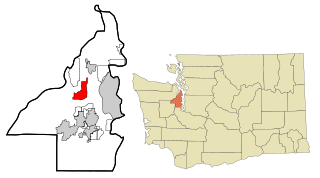
Kitsap County is located in the U.S. state of Washington. As of the 2020 census, its population was 275,611. Its county seat is Port Orchard, and its largest city is Bremerton. The county was formed out of King County and Jefferson County on January 16, 1857, and is named for Chief Kitsap of the Suquamish Tribe. Originally named Slaughter County, it was soon renamed.

Kingston is an unincorporated community and census-designated place (CDP) in Kitsap County, Washington, United States. The population was 2,099 at the 2010 census. Kingston is along the shores of Appletree Cove and Puget Sound, and is home to a major Washington State Ferry terminal linking it to Edmonds.

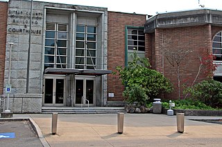
Port Orchard is a city in and the county seat of Kitsap County, Washington, United States. It is located 13 miles (21 km) due west of West Seattle and is connected to Seattle and Vashon Island via the Washington State Ferries run to Southworth. It is named after Port Orchard, the strait that separates Bainbridge Island from the Kitsap Peninsula.
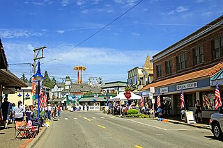
Poulsbo is a city on Liberty Bay in Kitsap County, Washington, United States. It is the smallest of the four cities in Kitsap County. The population was 9,200 at the 2010 census and an estimated 10,927 in 2018.
Silverdale is a census-designated place (CDP) in Kitsap County, Washington, in the United States. The population was 19,204 at the 2010 census. Despite many attempts at incorporation, Silverdale remains an unincorporated community.
Southworth is an unincorporated community and census-designated place (CDP) on Puget Sound in Kitsap County, Washington, United States. It is best known for being the west end of the Fauntleroy-Vashon Island-Southworth Washington State Ferries run. Landmarks include Southworth Grocery, a US Post Office, ferry terminal, clay cliffs and a private beach on the point. Next to the ferry is a popular place to launch kayaks for trips to nearby Blake Island. The population of the Southworth CDP was 2,185 at the 2010 census.

Hansville is an unincorporated community and census-designated place (CDP) in Kitsap County, Washington, United States. Its population was 3,858 as of the 2020 census. The coastal community is located at the northern end of the Kitsap Peninsula and is about 16 miles (26 km) northeast of Poulsbo, the nearest city.

The Colvos Passage is a tidal strait within Puget Sound in the American state of Washington running west of Vashon Island between the island and the Kitsap Peninsula. It lies just north of the Dalco Passage. Colvos Passage has a permanent predominantly northbound current, in contrast to the rest of Puget Sound which varies with the tide. The communities of Fragaria, Olalla, Sunrise Beach, Spring Beach, Maplewood, Lisabeula, Paradise Cove and Sylvan Beach are located on Colvos Passage.

The Kitsap Sun is a daily newspaper published in Bremerton, Washington, United States. It covers general news and serves Kitsap, Jefferson, and Mason counties on the west side of Puget Sound. It has a circulation of about 30,000 while reaching over 100,000 adult readers seven days a week.
Brownsville is an unincorporated community in Kitsap County, Washington, United States. It is located north of Bremerton and due east of Silverdale and on the north side of Burke Bay on the Kitsap Peninsula.
Chico is an unincorporated community and census-designated place (CDP) in Kitsap County, Washington, United States. Named in 1889 for a local Indian, Chico is located on the Dyes Inlet waterfront, southeast of Silverdale. At the 2010 census the community had a population of 2,259.
Retsil is an unincorporated community in Kitsap County, Washington, United States. It is located on the Puget Sound, and is known for its veterans facilities. Retsil is located within the Parkwood Census-designated place (CDP).
Eglon is an unincorporated community in Kitsap County, Washington, United States. The town has a community center, a church, a cemetery, a boat launch, a beach, and a picnic area. Its Fire Protection services are provided by North Kitsap Fire and Rescue.
Glenwood is an unincorporated community in Kitsap County, Washington, United States. Glenwood is 10 miles (16 km) south of Bremerton.
Port Gamble Tribal Community is a census-designated place (CDP) corresponding to the Port Gamble S'Klallam Reservation in Kitsap County, Washington, United States. The population was 916 at the 2010 census.
Lofall is an unincorporated community and census-designated place (CDP) located in Kitsap County, Washington, United States. The population was 2,289 at the 2010 census.
Crosby is an unincorporated community in Kitsap County, in the U.S. state of Washington.
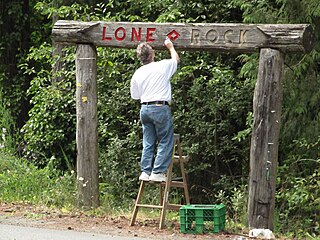
Lone Rock is an unincorporated community on the coast of the Hood Canal in Kitsap County, Washington.
Erlands Point is an unincorporated community and census-designated place (CDP) in Kitsap County, Washington, United States. As of the 2020 census, it had a population of 916. Prior to 2020, it was part of the Erlands Point-Kitsap Lake CDP.
Kitsap Lake is an unincorporated community and census-designated place (CDP) in Kitsap County, Washington, United States. As of the 2020 census, it had a population of 1,997. Prior to 2020, it was part of the Erlands Point-Kitsap Lake CDP.


