Harper, Washington

Last updated

Harper, Washington
USA Washington location map.svg
Red pog.svg
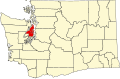
Harper
Location in Washington and the United States
Usa edcp location map.svg
Red pog.svg
Harper
Harper (the United States)
Coordinates: 47°31′14″N122°31′10″W / 47.52056°N 122.51944°W / 47.52056; -122.51944
Country United States
State Washington
County Kitsap
Elevation
16 ft (5 m)
Time zone UTC-8 (Pacific (PST))
  Summer (DST) UTC-7 (PDT)
GNIS feature ID1512273 [1]

Harper is an unincorporated community in Kitsap County, in the U.S. state of Washington. [2] It is part of the Southworth census-designated place.

History

A post office called Harper was established in 1900. [3] The community was named after F. C. Harper, a state legislator. [4]

References

  1. "Harper". Geographic Names Information System . United States Geological Survey, United States Department of the Interior.
  2. U.S. Geological Survey Geographic Names Information System: Harper, Washington
  3. "Post Offices". Jim Forte Postal History. Retrieved August 9, 2016.
  4. Meany, Edmond S. (1923). Origin of Washington geographic names. Seattle: University of Washington Press. p. 108.