Lofall, Washington | |
|---|---|
 Lofall  Lofall | |
| Coordinates: 47°48′41″N122°39′23″W / 47.81139°N 122.65639°W | |
| Country | United States |
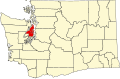
| State | Washington |
| County | Kitsap |
| Area | |
• Total | 2.00 sq mi (5.18 km2) |
| • Land | 2.00 sq mi (5.18 km2) |
| • Water | 0.0 sq mi (0.0 km2) |
| Elevation | 344 ft (105 m) |
| Population (2010) | |
• Total | 2,289 |
| • Density | 1,100/sq mi (440/km2) |
| Time zone | Pacific |
| ZIP code | 98370 |
| Area code | 360 |
| FIPS code | 53-39930 |
| GNIS feature ID | 2584998 [1] |
Lofall is an unincorporated community and census-designated place (CDP) located in Kitsap County, Washington, United States. The population was 2,289 at the 2010 census. [2]
Contents
A post office called Lofall was established in 1912, and remained in operation until 1934. [3] The post office was named after H. Lofall, the original owner of the land where the post office was. [4]
To its east lies Breidablick.