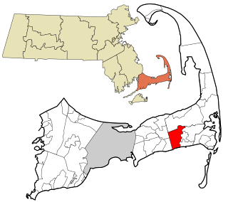
Northwest Harwich is a census-designated place (CDP) in the town of Harwich in Barnstable County, Massachusetts, United States. The population was 3,929 at the 2010 census. The CDP includes the Harwich villages of West Harwich, North Harwich, and Pleasant Lake, as well as a portion of the mailing area for Harwich Port.
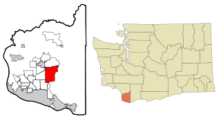
Hockinson is a census-designated place (CDP) in Clark County, Washington, United States. The population was 6,105 at the 2020 census.

Moses Lake North is a census-designated place (CDP) in Grant County, Washington, United States. It is also included in the Moses Lake micropolitan area. The population was 4,050 at the 2020 census.
Hobart is an unincorporated community and census-designated place (CDP) in King County, Washington, United States. The population was 6,767 at the 2020 census.

Lake Morton-Berrydale is a census-designated place (CDP) in King County, Washington, United States. The population was 10,474 at the 2020 census.

Lakeland North is a census-designated place (CDP) in King County, Washington, United States. The population was 13,663 at the 2020 census. Part of the community was annexed into neighboring Auburn in 2008.

Lakeland South is a census-designated place (CDP) in King County, Washington, United States. The population was 13,169 at the 2020 census.

East Port Orchard is a census-designated place (CDP) in Kitsap County, Washington, United States. The population was 5,262 at the 2020 census.

Erlands Point-Kitsap Lake is an unincorporated area and former census-designated place (CDP) in Kitsap County, Washington, United States. The population was 2,935 at the 2010 census. For the 2020 census, the area was split into two CDPs, Erlands Point and Kitsap Lake.

Indianola is a census-designated place (CDP) in Kitsap County, Washington, United States, located on the north shore of Port Madison on the Port Madison Indian Reservation, home of the Suquamish Indian Tribe. The population was 3,664 at the 2020 census. It was originally established as a summer community and was a stop for Mosquito Fleet ferries until the 1950s.

Kingston is an unincorporated community and census-designated place (CDP) in Kitsap County, Washington, United States. The population was 2,515 at the 2020 census. Kingston is along the shores of Appletree Cove and Puget Sound, and is home to a major Washington State Ferry terminal linking it to Edmonds.

Manchester is an unincorporated community and census-designated place (CDP) in Kitsap County, Washington, United States. The population was 5,714 at the 2020 census. Manchester is located on the Puget Sound approximately 10 miles from downtown Seattle, and is adjacent to county seat Port Orchard to its east. Today, Manchester labels itself as a village. It is small in size but is home to a Kitsap Regional Library (KRL) branch, a post office, an elementary school, and a beachfront park to serve its residents.

Navy Yard City is a census-designated place (CDP) in Kitsap County, Washington, United States. The population was 2,759 at the 2020 census.

Parkwood is a census-designated place (CDP) in Kitsap County, Washington, United States. The population was 7,635 at the 2020 census.

Suquamish is a census-designated place (CDP) in Kitsap County, Washington, United States. The population was 4,266 at the 2020 census. Comprising the Port Madison Indian Reservation, it is the burial site of Chief Seattle and was the site of the Suquamish tribe winter longhouse known as the Old Man House.

Tracyton is a census-designated place (CDP) in Kitsap County, Washington, United States. Its population was 5,967 at the 2020 census. It was named for 19th century Secretary of the Navy Benjamin F. Tracy.

Machias is a census-designated place (CDP) in Snohomish County, Washington, United States. The population was 1,264 at the 2020 census.
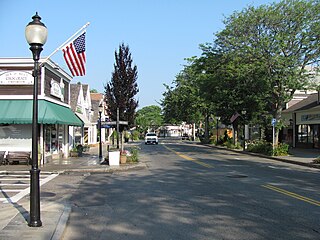
Falmouth is a census-designated place (CDP) consisting of the primary settlement in the town of Falmouth in Barnstable County, Massachusetts, United States. The population of the CDP was 3,799 at the 2010 census, out of 31,532 in the town as a whole. It was named after Falmouth, Cornwall, England.

Great Barrington is a census-designated place (CDP) located in the town of Great Barrington in Berkshire County, Massachusetts, United States. The population was 2,231 at the 2010 census, out of 7,104 in the entire town of Great Barrington.

Hudson is a census-designated place (CDP) comprising the densely developed central part of the town of Hudson in Middlesex County, Massachusetts, United States. The population of the CDP was 15,749 at the 2020 census, out of 20,092 in the entire town.

