Eglon is an unincorporated community in Kitsap County, Washington, United States. The town has a community center, a church, a cemetery, a boat launch, a beach, and a picnic area. Its Fire Protection services are provided by North Kitsap Fire and Rescue.
History
The earliest land deeds in this area were government grants to homesteaders, the first of which was recorded December 1, 1864 for 160 acres to settler Isidro Martyn, for having served in the US Army during the American Civil War. In 1891, another homesteader, Charles R. Silver, was granted 160 acres along the waterfront where a stream ran into Puget Sound, and named it Silver Creek. The surrounding area and its community soon became known as Silver Creek. Silver only held this land until 1894, when it was foreclosed on, and it was purchased by Edward Scannel, the lighthouse keeper at Point-No-Point. At this time, few landowners are believed to have lived in the area year round. Rather, they came to log and fish on their land, and lived in more established communities nearby, such as Kingston, Edmonds, and Seattle.[2]
First Eglon dock, c. 1914
In 1904, Albert Halvorsen, a Norwegian immigrant, purchased over a mile of waterfront from Scannel, including the former Silver property. He brought many of his relatives from Seattle to live on his land, and these settlers represented the first permanent residents of Silver Creek. Settlers had to row to either Edmonds or Point-No-Point for mail and supplies, and so in 1906, with the population beginning to grow, Halvorsen established a general store near the beach, and applied for a post office. Postal officials rejected the name Silver Creek, due to a Silver Creek, Washington already in existence, and so the name Eglon was chosen by the community, after Eglon, a figure in the Hebrew Bible.[3][2] The post office opened October 8, 1906, with Halvorsen's wife Marie Halvorsen as the first postmistress.[2]
Eglon first schoolhouseEglon Community Church
The Eglon school district was formed in 1907, for the nine school-aged children living in Eglon, with classes beginning on Jan 8, 1908. The first schoolhouse was built in 1908.[2]
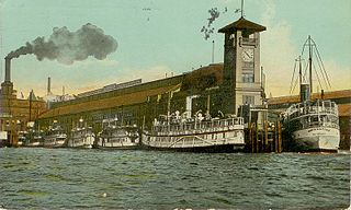
Industry increased in Eglon over the next decade. Cook's Camp, a logging operation was established in 1906 at Sandy Beach, south of Eglon Beach, followed by a sawmill in 1908, and a fish trap in 1916, built between Eglon Beach and Pilot Point. In 1912, a one-way wagon road to Kingston was constructed, providing the first road connection to the rest of the county. A community dock was constructed in 1913, but it was of poor quality, and had to be replaced in 1918. On November 18, 1918, regular ferry service was established by the Puget Sound Navigation Company to Colman Dock in Seattle, on the Mosquito Fleet steamer Puget. In 1919, the Port of Eglon was established, and the dock was sold to the Port for $1. Passengers, freight, mail, daily Seattle newspapers, and produce from the Public Market in Seattle, all came by boat. Other steamers that regularly frequented Eglon were: Dode, Perdita, "Weary Willy", Monticello, Dauntless, and Virginia III.[2]
Between 1918 and 1920, the Eglon Community Church was built, and still stands and holds services today. Many early church services were held in Norwegian or Swedish. In 1921, Camp Cohoe, a girls summer camp was founded. A larger Eglon schoolhouse was built in 1922, and today, is used as a community center.[2]
Logging in the area was increased in the 1920s by the arrival of Puget Mill Company in 1922, which first logged along Hansville Road, hauling logs by train to Gamble Bay, south of Little Boston, where they were then floated to the Port Gamble mill. In 1926, Puget Mill began logging closer to Eglon Beach, where they were floated from a logging dock built north of Eglon Beach. In the summer of 1929, a large forest fire burned much of the logged Puget Mill land. Firefighters were brought in from nearby towns to protect the Eglon dock, and with the help of a favorable wind, they were successful.[2]
Eglon community dock, store, and post office, c. 1950
In 1921, construction began on Hansville Road, which would provide an automobile connection to Eglon for the first time. The first car owners in Eglon would use the old wagon road, but often with the help of horses, and sometimes had to scale the many steep hills in reverse. Hansville Road was opened in sections and was finally complete in 1924, and Highway 104 opened in 1926, providing the final link to Kingston and its ferry connection to Edmonds. However, it was not until improvements were made in 1942 that the road was in good enough condition to be used year-round.[2]
The first telephone connection to Eglon was completed in December 1926, and the first electricity service in 1929.[2]
With the opening of the new road, by 1933, the Mosquito Fleet route to Eglon was so unprofitable that it was discontinued. For a year, Eglon was a flag stop for the passenger steamer Mohawk, passing three times a week, but was discontinued for lack of patronage in 1934.[2] The Eglon post office was closed in 1964.[4]
Related Research Articles
Snohomish County is a county located in the U.S. state of Washington. With an estimated population of 830,393 as of 2020, it is the third-most populous county in Washington, after nearby King and Pierce counties, and the 75th-most populous in the United States. The county seat and largest city is Everett. The county was created out of Island County on January 14, 1861 and is named for the Snohomish tribe.
Kitsap County is located in the U.S. state of Washington. As of the 2010 census, its population was 251,133. Its county seat is Port Orchard, and its largest city is Bremerton. The county was formed out of King County and Jefferson County on January 16, 1857, and is named for Chief Kitsap of the Suquamish Tribe. Originally named Slaughter County, it was soon renamed.
Indianola is a census-designated place (CDP) in Kitsap County, Washington, United States, located on the north shore of Port Madison on the Port Madison Indian Reservation, home of the Suquamish Indian Tribe. The population was 3,500 at the 2010 census. It was originally established as a summer community and was a stop for Mosquito Fleet ferries until the 1950s.
Kingston is an unincorporated community and census-designated place (CDP) in Kitsap County, Washington, United States. The population was 2,099 at the 2010 census. Kingston is along the shores of Appletree Cove and Puget Sound, and is home to a major Washington State Ferry terminal linking it to Edmonds.
Edmonds is a city in Snohomish County, Washington, United States. It is located in the southwest corner of the county, facing Puget Sound and the Olympic Mountains to the west. The city is part of the Seattle metropolitan area and is located 15 miles (24 km) north of Seattle and 18 miles (29 km) southwest of Everett. With a population of 39,709 residents in the 2010 U.S. census, Edmonds is the third most populous city in the county. The estimated population in 2019 was 42,605.
The Kitsap Peninsula lies west of Seattle across Puget Sound, in Washington state in the Pacific Northwest. Hood Canal separates the peninsula from the Olympic Peninsula on its west side. The peninsula, a.k.a. "Kitsap", encompasses all of Kitsap County except Bainbridge and Blake Islands, as well as the northeastern part of Mason County and the northwestern part of Pierce County. The highest point on the Kitsap Peninsula is Gold Mountain. The U.S. Navy's Puget Sound Naval Shipyard, and Naval Base Kitsap are on the peninsula. Its main city is Bremerton.
Seabeck is an unincorporated community and census-designated place (CDP) in Kitsap County, Washington, United States. The population was 1,105 at the 2010 census. Seabeck is a former mill town on Hood Canal.
State Route 104 (SR 104) is a 31.75-mile-long (51.10 km) state highway in the U.S. state of Washington, serving four counties: Jefferson on the Olympic Peninsula, Kitsap on the Kitsap Peninsula, and Snohomish and King in the Puget Sound region. It begins south of Discovery Bay at U.S. Route 101 (US 101) south of Discovery Bay and crosses the Hood Canal Bridge over Hood Canal to the terminus of SR 3 near Port Gamble. SR 104 continues southeast onto the Edmonds–Kingston Ferry to cross the Puget Sound and intersects SR 99 and Interstate 5 (I-5) before ending at SR 522 in Lake Forest Park. SR 104 also has a short spur route that connects the highway to SR 99 at an at-grade signal on the Snohomish–King county line.
Purdy is a small unincorporated community and census-designated place north of the city of Gig Harbor, at the junction of Washington State Routes 16 and 302 on the northern boundary of Pierce County, Washington.
Hansville is an unincorporated community and census-designated place (CDP) in Kitsap County, Washington, United States. Its population was 3,091 as of the 2010 U.S. Census. The coastal community is located at the northern end of the Kitsap Peninsula and is about 16 miles (26 km) northeast of Poulsbo, the nearest city.
Little Boston is a community in Kitsap County, Washington, United States. It is located on the east side of Port Gamble, an inlet or bay of Hood Canal, and is direct across the bay from the unincorporated community of Port Gamble. Little Boston is within the Port Gamble Indian Reservation, which houses the Port Gamble band of the S'Klallam tribe.
Olalla is a small unincorporated community in Kitsap County, Washington, United States. It is located on Colvos Passage on Puget Sound, just north of the Pierce County county line. Olalla used to be as large as Port Orchard, the county seat of Kitsap County. Olalla was settled in its early years by a large number of Norwegian and other Scandinavian immigrants because of its similarities to their native countries. Noted as early as the 1860s Olalla developed a commerce center by way of its good sea water access. The "old town" port located by the Olalla lagoon was made up of many business buildings, most on piers. Shipping and the mosquito fleet was very busy moving materials, goods and people.
Port Gamble is an unincorporated community on the northwestern shore of the Kitsap Peninsula in Kitsap County, Washington, United States. It is also a small, eponymous bay, along which the community lies, near the entrance to Hood Canal. The unincorporated communities of Port Gamble and Little Boston, part of Kitsap County, lie on the west and the east side, respectively, of the mouth of this bay. The Port Gamble Historic District, a U.S. National Historic Landmark, covers one of the nation's best-preserved western lumber towns.
The Puget Sound mosquito fleet was a multitude of private transportation companies running smaller passenger and freight boats on Puget Sound and nearby waterways and rivers. This large group of steamers and sternwheelers plied the waters of Puget Sound, stopping at every waterfront dock. The historical period defining the beginning and end of the mosquito fleet is ambiguous, but the peak of activity occurred between the First and Second World Wars.
The Manette Peninsula is a headland that is part of the larger Kitsap Peninsula, located on the eastern flank of the Kitsap Peninsula, in western Washington (state), USA.
The steamboat Monticello (2) operated in the early 1900s as part of the Puget Sound Mosquito Fleet. The vessel went through several reconstructions and remained in service until 1962, when she was lost in Alaska waters. Her later names were Penaco and Sea Venture. (This Puget Sound steamer should not be confused with the smaller Monticello, which also ran on Puget Sound, but was built in 1895 for Captain Z.J. Hatch of the Monticello Steamship Company.
The Edmonds–Kingston ferry is a ferry route across Puget Sound between Edmonds and Kingston, Washington. Since 1951 the only ferries employed on the route have belonged to the Washington state ferry system, currently the largest ferry system in the United States. The last regularly operated steam ferry on the West Coast of the United States made its final run on this route in 1969.
The Puget Sound region is a coastal area of the Pacific Northwest in the U.S. state of Washington, including Puget Sound, the Puget Sound lowlands, and the surrounding region roughly west of the Cascade Range and east of the Olympic Mountains. It is characterized by a complex array of saltwater bays, islands, and peninsulas carved out by prehistoric glaciers.
Colman Dock, also called Pier 52, is the primary ferry terminal in Seattle, Washington, United States. The original pier is no longer in existence, but the terminal, now used by the Washington State Ferry system, is still called "Colman Dock".
Camano was a steamboat built in 1906 at Coupeville, Washington which operated on Puget Sound from 1906 to 1917. Camano was later known as Tolo. As Tolo the vessel was sunk in 1917 as a result of a collision at sea. Four people died as a result.
This page is based on this Wikipedia article Text is available under the CC BY-SA 4.0 license; additional terms may apply. Images, videos and audio are available under their respective licenses.