Glacial erratic boulders of Kitsap County, Washington

Last updated
Map all coordinates using: OpenStreetMap  
Download coordinates as: KML  ·  GPX

Glacial erratic boulders of Kitsap County are large glacial erratic boulders of rock which were moved into Kitsap County, Washington by glacial action during previous ice ages.

Contents

Kitsap County was so extensively formed by glaciation that according to J Harlen Bretz almost any east-west traverse across the Kitsap Peninsula (shared with two other counties) will describe an ascending and descending profile across till ridges. [1]

List of boulders

Frog Rock , dynamited, moved off the road, and stacked in 20th century

47°41′46″N122°31′24″W / 47.69612°N 122.52347°W / 47.69612; -122.52347 (Frog Rock)

Bainbridge Island Frog Rock.jpg
Haleets , at Agate Point on Bainbridge Island, has petroglyphs said to be from before 400 CE

47°43′07.1″N122°32′40.1″W / 47.718639°N 122.544472°W / 47.718639; -122.544472 (Haleets)

Haleets petroglyph rock.JPG
Illahee Preserve erratic

At Illahee Preserve Almira parking lot [2]

47°36′51″N122°37′21″W / 47.6141°N 122.6225°W / 47.6141; -122.6225 (Illahee Preserve erratic)

No image.png
Illahee Road erratic, an "extremely large erratic of volcanic rock" [3]

47°36′02″N122°36′10″W / 47.60066°N 122.60268°W / 47.60066; -122.60268 (Illahee Road erratic)

No image.png
Lone Rock, the namesake landmark of the unincorporated community of Lone Rock, located on the Hood Canal tidal flat about 400 feet off shore. At least 50 feet (15 m) across. [4]
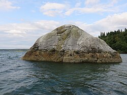
47°39′47″N122°46′12″W / 47.66297°N 122.769916°W / 47.66297; -122.769916 (Lone Rock)

Lone-Rock-Hood-Canal-Washington-18-Aug-2017.jpg

Related Research Articles

Missoula Floods Cataclysmic floods at the end of the last ice age, in eastern Washington state, US

The Missoula Floods refer to the cataclysmic floods that swept periodically across eastern Washington and down the Columbia River Gorge at the end of the last ice age. The glacial flood events have been researched since the 1920s. These glacial lake outburst floods were the result of periodic sudden ruptures of the ice dam on the Clark Fork River that created Glacial Lake Missoula. After each ice dam rupture, the waters of the lake would rush down the Clark Fork and the Columbia River, flooding much of eastern Washington and the Willamette Valley in western Oregon. After the rupture, the ice would reform, creating Glacial Lake Missoula again.

Grand Coulee An ancient river bed in the U.S. state of Washington

The Grand Coulee is an ancient river bed in the U.S. state of Washington. This National Natural Landmark stretches for about 60 miles southwest from Grand Coulee Dam to Soap Lake, being bisected by Dry Falls into the Upper and Lower Grand Coulee.

Glacial erratic piece of rock that differs from the size and type of rock native to the area in which it rests

A glacial erratic is a piece of rock that differs from the size and type of rock native to the area in which it rests. "Erratics" take their name from the Latin word errare, and are carried by glacial ice, often over distances of hundreds of kilometres. Erratics can range in size from pebbles to large boulders such as Big Rock in Alberta.

Channeled Scablands Landscape in eastern Washington, USA scoured by cataclysmic floods during the Pleistocene epoch

The Channeled Scablands at one time were a relatively barren and soil-free region of interconnected relict and dry flood channels, coulees and cataracts eroded into Palouse loess and the typically flat-lying basalt flows that remain after cataclysmic floods within the southeastern part of the U.S. state of Washington. The channeled scablands were scoured by more than 40 cataclysmic floods during the Last Glacial Maximum and innumerable older cataclysmic floods over the last two million years. These cataclysmic floods were repeatedly unleashed when a large glacial lake repeatedly drained and swept across eastern Washington and down the Columbia River Plateau during the Pleistocene epoch. The last of the cataclysmic floods occurred between 18,200 and 14,000 years ago.

J Harlen Bretz geologist

J Harlen Bretz was an American geologist, best known for his research that led to the acceptance of the Missoula Floods and for his work on caves. He was born to Oliver Joseph Bretz and Rhoda Maria Howlett, farmers in Saranac, Michigan, the oldest of five children. He earned a degree in biology from Albion College in 1905, where he also met his wife Fanny Chalis. Thereafter, he became interested in the geology of Eastern Washington state.

Joseph Pardee American geologist

Joseph T. Pardee was a U.S. geologist who worked for the U.S. Geological Survey, and contributed to the understanding of the origin of the Channeled Scablands. He discovered the trail of evidence left by Glacial Lake Missoula, a lake created by an ice dam 23 miles (37 km) wide and 0.5 miles (0.8 km) high during the most recent ice age. He discovered that when the dam broke, the water flowed towards the scablands, supporting J Harlen Bretz's theory of the cataclysmic floods.

Touchet Formation geological formation

The Touchet Formation or Touchet beds consist of large quantities of gravel and fine sediment which overlay almost a thousand meters of volcanic basalt of the Columbia River Basalt Group in south-central Washington and north-central Oregon. The beds consist of between 6 and 40 distinct rhythmites – horizontal layers of sediment, each clearly demarcated from the layer below. These Touchet beds are often covered by windblown loess soils which were deposited later; the number of layers varies with location. The beds vary in depth from 330 ft (100 m) at lower elevations where a number of layers can be found to a few extremely thin layers at the maximum elevation where they are observed.

Boulder Park

Boulder Park National Natural Landmark, of Douglas County, Washington, along with the nearby McNeil Canyon Haystack Rocks and Sims Corner Eskers and Kames natural landmarks, illustrate well-preserved examples of classic Pleistocene ice stagnation landforms that are found in Washington. These landforms include numerous glacial erratics and haystack rocks that occur near and on the Withrow Moraine, which is the terminal moraine of the Okanogan ice lobe.

Illahee, Washington Unincorporated community in Washington, United States

Illahee is an unincorporated community in Kitsap County, Washington, United States, between Bremerton and Silverdale. It is home to Illahee State Park and other local parks. The word "Illahee" means earth or country in the Native language Chinuk Wawa.

Richard Foster Flint was an American geologist.

Blue Hills (Washington)

The Blue Hills just west of Bremerton, Washington, also called the Bremerton Hills, Bald Hills, and Wildcat Hills, consist of Gold Mountain, Green Mountain, and several informally named hills. Reaching an elevation of 1761 feet, a thousand feet above the glacial till that fills the Puget Lowland, they form a prominent landmark visible around the region. They are formed of uplifted blocks of marine basalts, the steep-walled canyons between the various summits being the fissures between the blocks. In addition to Gold Mountain and Green Mountain are several other prominent peaks unofficially named according to their elevation :

Glacial erratic boulders of King County, Washington

Glacial erratic boulders of King County are large glacial erratic boulders of rock which were moved into King County, Washington by glacial action during previous ice ages.

Lake Lawrence erratic

The Lawrence Lake erratic is a glacial erratic boulder near Lake Lawrence in Thurston County, Washington. The boulder is about 15 feet (4.6 m) tall. Lake Lawrence itself was formed when the Vashon Glaciation created most of the topography seen in the Puget Sound region. The erratic is one of the southernmost in the Puget Sound region, near the limit of the Yelm lobe of the Vashon Glacier in the Rainier area.

Many glacial erratic boulders can be found in the Puget Sound region as far south as the Yelm area where the Puget Lobe of the glacier reached its maximum extent.

Glacial erratic boulders of Island County, Washington

Glacial erratic boulders in Island County are a remnant of the Pleistocene glaciation that created Puget Sound and transformed the surfaces of what are now Island County's main landmasses: Whidbey Island and Camano Island. South of Deception Pass, the two islands' surfaces and beaches are completely composed of glacial till. Abundant glacial erratic boulders lie on the islands, their beaches, and under the near-shore waters.

Hills in the Puget Lowland, between the Cascades and the Olympic Mountains, including the entire Seattle metropolitan area, are generally between 350–450 feet (110–140 m) and rarely more than 500 feet (150 m) above sea level. Hills are often notable geologically and for social reasons, such as the seven hills of Seattle.

Glacial Lake Russell glacial lake in what is now Puget Sound

During the Vashon Glaciation a series of lakes formed along the southern margin of the Cordilleran Ice Cap. In the Puget Sound depression, a series of lakes developed, of which Lake Russell was the largest and the longest lasting. Early Lake Russell’s surface was at 160 ft (49 m) above sea level, draining across the divide at Shelton, Washington into early Glacial Lake Russell. When the ice margin receded northward, the lake expanded. When it reached the Clifton channel outlet, the water levels dropped to 120 ft (37 m) above sea level. The new longer and lower level lake is referred to as Lake Hood. The glacier continued to retreat until the northern outlet of the Hood Canal was reached as the water level equalized with Glacial Lake Russell becoming part of that body of water.

Lake Skokomish glacial lake in what is now the Hood Sound

During the Vashon Glaciation a series of lakes formed along the southern margin of the Cordilleran Ice Cap. In the Hood Canal depression, two significant lake stages existed, Lake Skokomish and Lake Hood. Early Lake Skokomish’s surface was at 350 ft (110 m) above sea level, draining across the divide at Shelton, Washington into early Glacial Lake Russell. As the glacier receded northward, this freshwater lake grew in size, until the ice was north of the Clifton channel. With the opening of the Clifton channel, the water dropped to 160 m (520 ft) above sea level. This longer and lower level lake is referred to as Lake Hood. The glacier continued to recede northward until it reached the Poulsbo channel. Here, the water level equalized to Glacial Lake Russell nolonger having a separate identify.

Lake Puyallup developed along the south edge of the Puget Sound Glacier

Lake Puyallup developed along the south edge of the Puget Sound Glacier. The glacier was in retreat northward after having reached its most southerly point. Drainage off the north face of Mount Rainier and the melting ice of the glacier was trapped in the valley of the Puyallup River. As the glacier moved north, the lake grew until it reached its largest capacity with the glacier at the glacial front across the Puyallup valley just south of Commencement Bay at Tacoma and northern bend of the White River at Auburn. When the ice retreated further north, it was reduced in depth and volume and takes on the name of Lake Tacoma.

Lake Tacoma

Lake Tacoma is the name given the freshwater lake in the basin of the Puyallup River and the Green River at the point in time that the Vashon Glacier had receded northward into Commencement Bay. Prior to this, it was referred to as the Lake Puyallup. The bluff on which this city is built is used as the landmark where Lake Puyallup ceased and it became Lake Tacoma.

References

  1. Bretz, J Harlen (1913), Glaciation of the Puget Sound Region (PDF), Washington Geological Survey, p. 220
  2. Illahee Preserve Stewardship Committee (February 23, 2015), Illahee Preserve Stewardship Plan (revised working draft) (PDF), archived from the original (PDF) on March 4, 2016, retrieved April 20, 2015
  3. Sceva, Jack E. (1957), "Geology and Ground-Water Resources of Kitsap County Washington" (PDF), Water-Supply Paper 1413, U.S. Geological Survey, p. 22
  4. Measured on Google Maps overhead imagery August 24, 2017.