Glen Echo Creek

Last updated
Glen Echo Creek
Cemetery Creek
Glen Echo Creek Oakland.jpg
A section of Glen Echo Creek in Oak Glen Park
Location
CountryUnited States
StateCalifornia
County Alameda
City Oakland
Physical characteristics
Source Oakland Hills
Mouth Lake Merritt
  coordinates
37°48′38″N122°15′42″W / 37.81062°N 122.26169°W / 37.81062; -122.26169 Coordinates: 37°48′38″N122°15′42″W / 37.81062°N 122.26169°W / 37.81062; -122.26169
Basin size2.6 square miles (6.7 km2) [1]
Basin features
Tributaries 
  leftRockridge Branch, Broadway Branch

Glen Echo Creek (also known as Cemetery Creek) is a creek that runs from the Oakland Hills to Lake Merritt in Oakland, California. Although most of it is underground, the creek does surface in several locations. [2] It has two branches, the Rockridge Branch and the Broadway Branch. [1]

Contents

Watershed and geography

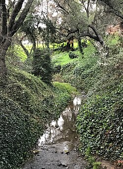
Glen Echo Creek is part of the 2.6-square-mile Glen Echo Creek Watershed and drains parts of Upper Rockridge, Piedmont Avenue, and Piedmont. Both the main creek and its Rockridge Branch start in the Oakland Hills around the Rock Ridge outcroppings. [1] Glen Echo Creek runs past the Mountain View Cemetery, then through the Piedmont Avenue neighborhood, where it surfaces for a stretch that includes the Glen Echo Creek Park pocket park. [3] After continuing underground in a culvert, it again surfaces at Oak Glen Park along Richmond Boulevard between Westfall Avenue and Randwick Avenue. [2] [1] From there, it continues mostly underground to Lake Merritt.

The Rockridge Branch flows from the hills to a pond near Pleasant Valley Avenue and then continues as the Broadway Branch. It surfaces briefly near 38th Street and Manila Avenue before continuing under Mosswood Park and eventually joining the main creek near Lake Merritt. [1]

History

In 1905, inspired by the City Beautiful Movement, developers Frank and Wickham Havers purchased and protected the Oak Glen Park area, which contains a 1,500-feet section of the creek surrounded by live oaks. A stone bridge and pergola were added in 1911, but have fallen into disrepair. [3] [2]

Piedmont Avenue residents first worked to protect Glen Echo Creek in 1976, when the Alameda County Flood Control and Water Conservation District proposed to pave over and redevelop the open-air section of creek that would later become Glen Echo Creek Park. In 1984, the creek was damaged by bulldozers deployed by the flood control district. A woman lay in front of the bulldozers, stopping them, and she was then able to garner support from neighborhood groups to successfully oppose the project. The flood control district then had to repair the damage. The section of creek was stabilized and restored, and replanted with native riparian plants and redwood, maple, and alder trees. By 2001, this section of the creek was again in disrepair, and was again restored by Oakland in 2002. [3]

In 2015, the East Bay Municipal Utility District accidentally spilled 140 cubic yards of cement into the creek in Upper Rockridge. [4] EBMUD was fined by the California Regional Water Quality Control Board but not criminally charged. [5]

See also

Related Research Articles

Rouge River (Ontario) River in Ontario, Canada

The Rouge River is a river in Markham, Pickering, Richmond Hill and Toronto in the Greater Toronto Area of Ontario, Canada. The river flows from the Oak Ridges Moraine to Lake Ontario at the eastern border of Toronto, and is the location of Rouge Park, the only national park in Canada within a municipality. At its southern end, the Rouge River is the boundary between Toronto and southwestern Pickering in the Regional Municipality of Durham.

Lake Merritt

Lake Merritt is a large tidal lagoon in the center of Oakland, California, just east of Downtown. It is surrounded by parkland and city neighborhoods. It is historically significant as the United States' first official wildlife refuge, designated in 1870, and has been listed as a National Historic Landmark since 1963, and on the National Register of Historic Places since 1966. The lake features grassy shores; several artificial islands intended as bird refuges; an interpretive center called the Rotary Nature Center at Lakeside Park; a boating center where sailboats, canoes and rowboats can be rented and classes are held; and a fairy tale themed amusement park called Children's Fairyland. A popular walking and jogging path runs along its perimeter. The circumference of the lake is 3.4 miles (5.5 km) and its area is 155 acres (63 ha).

Piedmont Avenue (Oakland, California) Neighborhood of Oakland in Alameda, California, United States

The Piedmont Avenue neighborhood is a residential and commercial district in the North Oakland region of Oakland, California. It is named for Piedmont Avenue, a commercial street known for dining and retail. The neighborhood is roughly bounded by Temescal and Broadway on the west, Oakland Avenue and the City of Piedmont on the east, the Mountain View Cemetery on the north, and the MacArthur Freeway section of Interstate 580 on the south.

Grand Lake, Oakland, California Neighborhood of Oakland in Alameda, California, United States

Grand Lake, or the Grand Lake District, is a neighborhood in Oakland, California, United States. The neighborhood is located in the northeast corner of Lake Merritt, where Grand Avenue and Lakeshore Avenue pass under Interstate 580. It borders Adams Point to the west, Trestle Glen/Crocker Highlands to the east, and the city of Piedmont to the north. It lies at an elevation of 52 feet.

Buffalo Bayou

Buffalo Bayou is a slow-moving river which flows through Houston in Harris County, Texas. Formed 18,000 years ago, it has its source in the prairie surrounding Katy, Fort Bend County, and flows approximately 53 miles (85 km) east through the Houston Ship Channel into Galveston Bay and the Gulf of Mexico. In addition to drainage water impounded and released by the Addicks and Barker reservoirs, the bayou is fed by natural springs, surface runoff, and several significant tributary bayous, including White Oak Bayou, Greens Bayou, and Brays Bayou. Additionally, Buffalo Bayou is considered a tidal river downstream of a point 440 yards (400 m) west of the Shepherd Drive bridge in west-central Houston.

Montclair, Oakland, California Neighborhood of Oakland in Alameda, California, United States

Montclair is a neighborhood in Oakland, California, United States. Montclair is located along the western slope of the Oakland Hills from a valley formed by the Hayward Fault to the upper ridge of the hills.

Rockridge, Oakland, California Neighborhood of Oakland in Alameda, California, United States

Rockridge is a residential neighborhood and commercial district in Oakland, California. Rockridge is generally defined as the area east of Telegraph Avenue, south of the Berkeley city limits, west of the Oakland hills and north of the intersection of Pleasant Valley Avenue/51st Street and Broadway. Rockridge was listed by Money Magazine in 2002 as one of the "best places to live".

Temescal, Oakland, California Neighborhood of Oakland in Alameda, California, United States

Temescal is one of the oldest neighborhoods in Oakland, California, located in North Oakland, and centered on Telegraph Avenue. The neighborhood derives its name from Temescal Creek, a significant watercourse in the city.

Clear Creek (Atlanta)

Clear Creek is a stream in northeast Atlanta that is a tributary to Peachtree Creek and part of the Chattahoochee River watershed. It has two main branches, one originating east of the high ground along which Boulevard runs and another to the west originating on the northeast side of downtown Atlanta. The easterly branch of Clear Creek begins in several springs and branches in what are now Inman Park and the Old Fourth Ward. Flowing north, the creek was joined by other branches and springs, including Angier Springs near the end of Belgrade Avenue and the so-called Ponce de Leon Springs, which were “discovered” during railroad construction in the 1860s and gave rise to the eponymous park and avenue.

Oakland Public Library

The Oakland Public Library is the public library in Oakland, California. Opened in 1878, the Oakland Public Library currently serves the city of Oakland, along with neighboring smaller cities Emeryville and Piedmont. The Oakland Public Library has the largest collection of any public library in the East Bay, featuring approximately 1.5 million items. It consists of a main library located in downtown Oakland, and 16 branch libraries throughout the city.

Downtown Oakland

Downtown Oakland is the central business district of Oakland, California, United States; roughly bounded by both the Oakland Estuary and Interstate 880 on the southwest, Interstate 980 on the northwest, Grand Avenue on the northeast, and Lake Merritt on the east.

Sausal Creek (Alameda County)

Sausal Creek, 3.1 miles (5.0 km) long, is one of the principal creeks in Oakland, California.

Park River (Connecticut)

The Park River, sometimes called the Hog River, flows through and under the city of Hartford, Connecticut. Between 1940 and the 1980s, the 2.3-mile (3.7 km) river was buried by the Army Corps of Engineers to prevent the spring floods regularly caused by increased surface runoff from urban development.

San Antonio, Oakland, California Neighborhood of Oakland in Alameda, California, United States

San Antonio is a large district in Oakland, California, encompassing the land east of Lake Merritt to Sausal Creek. It is one of the most diverse areas of the city. It takes its name from Rancho San Antonio, the name of the land as granted to Luís María Peralta by the last Spanish governor of California.

Islais Creek

Islais Creek or Islais Creek Channel is a small creek in San Francisco, California. The name of the creek is derived from a Salinan Native American word "slay" or "islay", the name for the Prunus ilicifolia wild cherries. Around the time of the Gold Rush, the area became an industrial hub, and the condition of the creek worsened. After the devastating 1906 San Francisco earthquake, the city decided to reclaim the creek using earthquake debris, reducing the waterbody to its present size. Though much of Islais Creek has been converted to an underground culvert, remnants still exist today at both Glen Canyon Park and Third Street. Several community organizations are dedicated to preserve these remnants, as they are important wildlife habitats.

Oakland Hills, Oakland, California

Oakland Hills is an informal term used to indicate the city neighborhoods lying within the eastern portion of Oakland, California. The northernmost neighborhoods were devastated by the Oakland firestorm of 1991.

Permanente Creek

Permanente Creek is a 13.3-mile-long (21.4 km) stream originating on Black Mountain in Santa Clara County, California, United States. It is the namesake for the Kaiser Permanente health maintenance organization. Named by early Spanish explorers as Arroyo Permanente or Rio Permanente because of its perennial flow, the creek descends the east flank of Black Mountain then courses north through Los Altos and Mountain View culminating in southwest San Francisco Bay historically at the Mountain View Slough but now partly diverted via the Permanente Creek Diversion Channel to Stevens Creek and the Whisman Slough in San Francisco Bay.

Laguna Creek watershed

The Laguna Creek watershed consists of 25.1 square miles (100 km2) of land within northern California's Alameda County. The watershed drains the foothills of the Diablo Range south of Niles Canyon. To the southeast, the area of Mission Peak Regional Preserve around Mission Peak is included. Agua Caliente, Canada del Aliso, Mission, Morrison, Sabercat, Vargas, and Washington creeks drain the area of the watershed. They drain into Laguna Creek and eventually Mud Slough.

References

  1. 1 2 3 4 5 "Glen Echo Creek Watershed | ACFCD" . Retrieved 2019-03-08.
  2. 1 2 3 Mailman, Erika. "Glen Echo Creek's Parks - Oakland Magazine - July-August 2012 - Oakland, California". www.oaklandmagazine.com. Retrieved 2019-03-08.
  3. 1 2 3 Riley, Ann L. (2016-07-12). Restoring Neighborhood Streams: Planning, Design, and Construction. Island Press. pp. 66–80. ISBN   9781610917407.
  4. "Cement spill clogs Glen Echo Creek in Oakland". ABC7 San Francisco. 2015-04-08. Retrieved 2019-03-08.
  5. "State Fines East Bay MUD Over Oakland Cement Spill". KQED. 2016-08-24. Retrieved 2019-03-08.