The West Highland Line
| Preceding station | | Following station | ||
|---|---|---|---|---|
| Crianlarich Line and station open | North British Railway West Highland Railway | Ardlui Line and station open | ||
Glen Falloch Halt | |
|---|---|
| General information | |
| Location | Between Ardlui and Crianlarich, Stirling Scotland |
| Coordinates | 56°20′28″N4°43′27″W / 56.341142°N 4.724205°W |
| Grid reference | NN31711986 |
| Platforms | 1 |
| Other information | |
| Status | Disused |
| History | |
| Original company | London and North Eastern Railway |
| Key dates | |
| 10 April 1946 | Opened [1] [2] |
| Circa 1948 | Closed |
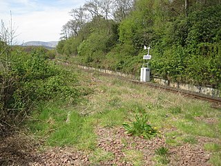
Glen Falloch Halt railway station was a remote rural railway station in Glen Falloch, Stirlingshire, Scotland. Opened in 1946 by the LNER, it was located in Glen Falloch on the Ardlui side of the viaduct, but reported out of use by around 1948. [1]
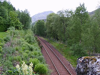
The West Highland Railway opened the line to passengers on 7 August 1894; later it was operated by the North British Railway, until in 1923 it became part of the London and North Eastern Railway. In 1948 the line became part of the Scottish Region of British Railways following nationalisation.
Glen Falloch Halt or Platform had a single platform and was opened by the LNER in 1946, but it closed around 1948. Records show that it was not opened as a standard railway station for the general public and it was not listed in the 1948 British Railways (Scottish Region) timetable. [3] The RCAHMS refer to the halt as being temporary. [4]
Well built 'slab' of concrete construction and a gravel surface, the curved single platform remnants are still present. It had a name board reading 'Glen Falloch', a single lamp for lighting and a small shed was present as a shelter or store. [5] A footpath ran from the halt to the Drovers Inn at Inverarnan.
After World War II many German and Italian ex-prisoners stayed in Scotland, and it is recorded that a small prisoner of war (POW) camp had been located at Glen Falloch, where a lot of forestry work was carried out. German and Italian POWs had been involved in the early stages of the construction of the Sloy Hydro-Electric facility between Loch Sloy and Inveruglas, on the west bank of Loch Lomond. [6]
Construction at the Loch Sloy project began in May 1945, under the auspices of the North of Scotland Hydro-Electric Board, and it was completed in 1949, dates that largely coincide with the known use of Glen Falloch Halt located near the old POW camp.
Glen Falloch Halt may have been used by men building the aqueducts and tunnels that collected water from the Glen Falloch burns and carried it to Loch Sloy. [7] The near by station of Inveruglas was a similar but larger station with sidings, a passing loop, etc and was built in connection with the Loch Sloy hydroelectric scheme.
The prisoners-of-war were carried from Faslane Platform near Faslane Junction and Whistlefield to Inveruglas or Glen Falloch. [8]
| Preceding station | | Following station | ||
|---|---|---|---|---|
| Crianlarich Line and station open | North British Railway West Highland Railway | Ardlui Line and station open | ||

Argyll and Bute is one of 32 unitary council areas in Scotland and a lieutenancy area. The current lord-lieutenant for Argyll and Bute is Jane Margaret MacLeod. The administrative centre for the council area is in Lochgilphead at Kilmory Castle, a 19th-century Gothic Revival building and estate. The current council leader is Councillor Jim Lynch.
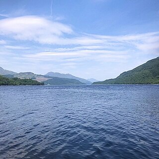
Loch Lomond is a freshwater Scottish loch which crosses the Highland Boundary Fault, often considered the boundary between the lowlands of Central Scotland and the Highlands. Traditionally forming part of the boundary between the counties of Stirlingshire and Dunbartonshire, Loch Lomond is split between the council areas of Stirling, Argyll and Bute and West Dunbartonshire. Its southern shores are about 23 kilometres (14 mi) northwest of the centre of Glasgow, Scotland's largest city. The Loch forms part of the Loch Lomond and The Trossachs National Park which was established in 2002.

The Arrochar Alps are a group of mountains located around the heads of Loch Long, Loch Fyne, and Loch Goil. They are part of the Grampian mountains range, which stretch across Scotland. The villages of Arrochar and Lochgoilhead are the nearest settlements. Many of the mountains are located on the Cowal Peninsula in Argyll and Bute, west of Scotland.

Ardlui is a hamlet in Argyll and Bute, Scottish Highlands. It is located at the head of Loch Lomond. It is on the A82 road between Crianlarich and Glasgow and Ardlui railway station is on the West Highland Line between Glasgow Queen Street and Oban or Fort William.

Arrochar and Tarbet railway station is a railway station on the West Highland Line in Scotland. It stands between the villages of Arrochar and Tarbet. It is sited 19 miles 45 chains (31.5 km) from Craigendoran Junction, near Helensburgh, between Ardlui and Garelochhead. ScotRail manage the station and operate most services, with others provided by Caledonian Sleeper.

Ardlui railway station is a rural railway station, serving Ardlui at the north end of Loch Lomond, in Scotland. The station is located on the West Highland Line, sited 27 miles 43 chains (44.3 km) from Craigendoran Junction, near Helensburgh, between Crianlarich and Arrochar and Tarbet. ScotRail manage the station and operate most services, others provided by Caledonian Sleeper.

The West Highland Railway was a railway company that constructed a railway line from Craigendoran to Fort William and Mallaig. The line was built through remote and difficult terrain in two stages: the section from Craigendoran to Fort William opened in 1894, with a short extension to Banavie on the Caledonian Canal opening in 1895.

Ben Vane is a mountain in the Arrochar Alps of Argyll, in the Southern Highlands of Scotland. It reaches 915 metres (3,002 ft), making it a Munro. It lies between Beinn Ìme and Ben Vorlich.

Portincaple is a hamlet on the shores of Loch Long in Argyll and Bute, Scotland. It was once a fishing village sending its catch to market via the old railway station at Whistlefield.
Rhu is a closed railway station located in the village of Rhu, in Argyll and Bute, Scotland, on the east shore of Gare Loch. It is located towards the southern end of the West Highland Railway.
The Faslane Branch was a standard gauge military railway built during World War II to serve "Military Port No.1" at Faslane, west of Glasgow in Scotland.

Inversnaid is a small rural community on the east bank of Loch Lomond in Scotland, near the north end of the loch. It has a pier and a hotel, and the West Highland Way passes through the area. A small passenger ferry runs from Inversnaid to Inveruglas on the opposite shore of the loch, and also to Tarbet. There is a seasonal ferry that also operates between Ardlui and Ardleish as well, which is a walkable distance from Inversnaid. To reach Inversnaid by road involves a 15-mile (24-kilometre) route from Aberfoyle. Nearby is an alleged hideout of Rob Roy MacGregor known as Rob Roy's Cave. The cave is difficult to access, and is best seen from Loch Lomond, where there is white paint indicating the location of the hideout.

The Loch Sloy Hydro-Electric Scheme is a hydro-electric facility situated between Loch Sloy and Inveruglas on the west bank of Loch Lomond in Scotland. It is also within the Arrochar Alps.
The Inverarnan Canal was a short length of canal terminating at Garbal, close to the hamlet of Inverarnan, Scotland. This waterway once linked the old coaching inn, now the Drovers Inn, at Inverarnan, on the Allt Arnan Burn to the River Falloch and passengers could continue southward to Loch Lomond and finally to Balloch. From Inverarnan stagecoaches ran to various destinations in the north of Scotland.
Fersit Halt railway station named after the nearby hamlet of Fersit, was situated close to Tulloch railway station in Lochaber, Highland council area, Scotland. Fersit was a remote rural temporary private halt at the north end of Loch Treig where workers were housed who worked on the Lochaber hydroelectric scheme. The halt was opened in 1931 by the LNER, it was located near the site of a contractors railway ballast siding.

Glen Douglas Halt railway station was known as Craggan in the line's construction reports, also Glen Douglas Siding, Glen Douglas Platform (Private), Glen Douglas (Private) and finally Glen Douglas Halt. Opened by the North British Railway in 1894 its status has changed several times along with its official name. The form Glendouglas was also sometimes used, such as on the platform name board.
Inveruglas was a remote temporary private railway station near the hamlet of Inveruglas, Argyll and Bute, Scotland. Opened in 1945 by the LNER, it was built in connection with the construction of the Sloy Hydro-Electric facility and was located on the Ardlui side of the Inveruglas Viaduct and recorded to be out of use by around 1948.

Whistlefield, later Whistlefield Halt, was a minor station on the West Highland Line 10.30 miles from Craigendoran Junction railway station near the hamlet of Portincaple on Loch Long, Argyll and Bute, Scotland. Opened in 1896 by the West Highland Railway, it was built on a single track section without a passing loop in between Garelochhead and Glen Douglas and closed by the British Railways Board in 1964.
Faslane Platform railway station or Faslane Junction Platform railway station was a temporary private railway station located near the Stuckendoff PoW camp, Shandon, Argyll and Bute, Scotland. Opened in 1945 by the LNER in connection with the construction of the Loch Sloy Hydro-Electric facility and was located on the Shandon side of the Chapel Burn and recorded to be out of use by around 1949 in the British Railways era.