Glen Vowell

Last updated

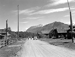
Glen Vowell is an Indian reserve community of the Gitxsan people in the Hazelton area of the Skeena Country of northwestern British Columbia, Canada. It is located on the west side of the Skeena River between Hazelton and Kispiox. Its traditional name is Sik i dak, which has also been spelled Sikadoak and is reflected in the name of the reserve, Sik-e-dahk IR 2. [1] Also nearby is another Indian reserve, Anlaw Indian Reserve No. 4. [2] The band government of the reserve is the Glen Vowell Indian Band, which also goes by the name Sik-e-Dakh. [3]

In Canada, an Indian reserve is specified by the Indian Act as a "tract of land, the legal title to which is vested in Her Majesty, that has been set apart by Her Majesty for the use and benefit of a band."

Gitxsan ethnic group

Gitxsan are an indigenous people of Canada whose home territory comprises most of the area known as the Skeena Country in English. Gitksan territory encompasses approximately 53,000 square kilometres (20,000 sq mi) of land, from the basin of the upper Skeena River from about Legate Creek to the Skeena's headwaters and its surrounding tributaries. Part of the Tsimshianic language group, their culture is considered to be part of the civilization of the Pacific Northwest Coast, although their territory lies in the Interior rather than on the Coast. They were at one time also known as the Interior Tsimshian, a term which also included the Nisga'a, the Gitxsan's neighbours to the north. Their neighbours to the west are the Tsimshian while to the east the Wet'suwet'en, an Athapaskan people, with whom they have a long and deep relationship and shared political and cultural community.

Hazelton, British Columbia Village in British Columbia, Canada

Hazelton is a village located at the junction of the Bulkley and Skeena Rivers in northern British Columbia, Canada. It was founded in 1866 and has a population of 305 (2011). The nearby larger community of New Hazelton is the northernmost point of the Yellowhead Highway, a major interprovincial highway which runs from Prince Rupert, British Columbia to Portage la Prairie, Manitoba.

The site was first identified on official maps in BC Mines Department records from 1910 as ""Glenvowell Salvation Army Mission". By 1922 this was adjusted to "Glen Vowell (Mission)" and as "Glen Vowell (Indian Village & Mission)" in the 1930 BC Gazetteer. [4]

The name is derived from that of Arthur Stewart Vowell, who surveyed the townsite in 1898 during the eponymous Vowell Commission, one of a series of Royal Commissions concerned with allocating Indian Reserves across British Columbia.

Coordinates: 55°18′44″N127°40′24″W / 55.31222°N 127.67333°W / 55.31222; -127.67333

Geographic coordinate system Coordinate system

A geographic coordinate system is a coordinate system that enables every location on Earth to be specified by a set of numbers, letters or symbols. The coordinates are often chosen such that one of the numbers represents a vertical position and two or three of the numbers represent a horizontal position; alternatively, a geographic position may be expressed in a combined three-dimensional Cartesian vector. A common choice of coordinates is latitude, longitude and elevation. To specify a location on a plane requires a map projection.

See also

Ksan Historical Village and living museum in Ksan is near Hazelton at the confluence of the Skeena and Bulkley Rivers.

'Ksan is a historical village and living museum of the Gitxsan Indigenous people in the Skeena Country of Northwestern British Columbia, Canada. 'Ksan is located near Hazelton at the confluence of the Skeena and Bulkley Rivers on Gitxsan territory.

Gitxsan Nation is one of Canada's First Nations and is a name used when referring to the Office of the Hereditary Chiefs of the Gitxsan, which is the formal governing body of the Gitxsan people. Their territories are located in the Skeena Watershed of British Columbia, Canada, covering 35,016 square kilometers of land.

Related Research Articles

Tsimshian ethnic group

The Tsimshian are an indigenous people of the Pacific Northwest Coast. Their communities are mostly in coastal British Columbia and far southern Alaska, around Terrace and Prince Rupert in British Columbia, and Alaska's Annette Islands. The Tsimshian people consist of approximately 10,000 members of seven First Nations. The Tsimshian are one of the largest First Nations peoples in northwest British Columbia. Some Tsimshian migrated to Annette Island, Alaska, where their descendants in the Metlakatla Indian Community number about 1450.

Skeena River river in Canada

The Skeena River is the second-longest river entirely within British Columbia, Canada. Since ancient times, the Skeena has been an important transportation artery, particularly for the Tsimshian and the Gitxsan—whose names mean "inside the Skeena River" and "people of the Skeena River," respectively. The river and its basin sustain a wide variety of fish, wildlife, and vegetation; and communities native to the area depend on the health of the river. The Tsimshian migrated to the Lower Skeena River, and the Gitxsan occupy territory of the Upper Skeena.

Kitwanga Mountain Provincial Park is a provincial park in British Columbia, Canada located on the north side of the Skeena River just west of the Gitxsan community of Kitwanga (Gitwangak).

Bulkley Valley

The Bulkley Valley is located in the northwest Central Interior of British Columbia, Canada.

Ross Lake Provincial Park is a provincial park in British Columbia, Canada, located south of Nine Mile Mountain, just east of Hazelton in the Skeena Country, comprising c. 307 ha.

Gwaʼsala-ʼNakwaxdaʼxw Nations

The Gwa'Sala-Nakwaxda'xw Nations are a union of two Kwakwaka'wakw peoples in a band government based on northern Vancouver Island in British Columbia, Canada, whose main reserve community is near the town of Port Hardy in the Queen Charlotte Strait region of the Central Coast region of British Columbia, Canada. The band government is a member of the Kwakiutl District Council and, for treaty negotiation purposes, the Winalagalis Treaty Group which includes three other members of the Kwakiutl District Council.

Gitsegukla Village

Gitsegukla is a Gitxsan community of about 500 at the confluence of the Kitseguecla and Skeena Rivers, approximately 40 km southwest of Hazelton, British Columbia. The community is on Gitsegukla Indian Reserve No. 1.

Kispiox human settlement in Canada

Kispiox is a Gitxsan village of approximately 550 in the Kispiox Valley, at the confluence of the Kispiox and Skeena Rivers in British Columbia. Located 13 km north of Hazelton, the community is situated within the Kispiox Indian Reserve and is managed by the Kispiox Band Council.

Kitwanga village in British Columbia

Kitwanga or Gitwangak or Gitwangax is located where the Kitwanga River runs into the Skeena River in British Columbia. A long-standing village before contact, the village is within Gitwangak Indian Reserve No. 1.

Gitwangak Battle Hill National Historic Site village in Canada

Gitwangak Battle Hill National Historic Site, formerly known as Kitwanga Fort National Historic Site is a National Historic Site of Canada located at Kitwanga, British Columbia in the Skeena Country of Northwestern British Columbia, Canada. The reserve now called 'Gitwangax'. This is to distinguish it from the adjacent lumber milling town, Kitwanga. 'Battle Hill' was an 18th-century earthwork fortress, located in Kitwanga. The site includes a trail with interpretive signs. The park was developed by George Macdonald, whose archaeological study was of the site, and who was the Director of the National Museum of Civilization until the opening of its current building.

Gitanyow

Gitanyow is an Indian reserve community of the Gitxsan people, located on the Kitwanga River 8 km south of Kitwancool Lake, at the confluence of Kitwancool Creek. The community is located on Gitanyow Indian Reserve No. 1.

Actaeon Sound is a sound in the Queen Charlotte Strait region of the Central Coast of British Columbia, branching off northeasterly from the north side of Drury Inlet near its head on the mainland of British Columbia to the north of the town of Port McNeill, on the opposite side of Queen Charlotte Strait. On the south side of the sound is the Bond Peninsula at 50°56′50″N127°06′55″W, which is formed by a sidewater, Bond Lagoon at 50°56′34″N127°06′34″W, both presumably named in 1865 by Captain Pender, in association with other Admiralty and HMS Actaeon-related names.

The Gitxsan Treaty Society handles Treaty negotiations in the BC Treaty Process for a number of First Nations in northwestern British Columbia

The Gitanmaax Band is a band government of the Gitxsan people, based near the meeting of the Skeena and Bulkley Rivers, adjacent to the village of Hazelton and 5 km west of New Hazelton, in northwestern British Columbia, Canada.

Vowell is a surname. Notable people with the surname include:

The Kispiox River is a river in the Skeena Country of British Columbia, Canada. It is a tributary of the Skeena River, flowing southeast to meet that river above its confluence with the Bulkley near Hazelton. It forms the eastern boundary of the Kispiox Range subdivision of the Hazelton Mountains.

Drury inlet is an inlet in the Queen Charlotte Strait region of the Central Coast of British Columbia, Canada, extending west from Wells Passage to the northwest of North Broughton Island, northwest of the town of Port Hardy. Branching off to the northeast from the north side of the head of the inlet is Actaeon Sound.

References