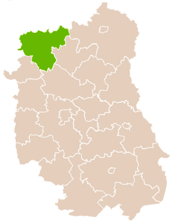
Gmina Stanin is a rural gmina in Łuków County, Lublin Voivodeship, in eastern Poland. Its seat is the village of Stanin, which lies approximately 14 kilometres (9 mi) south-west of Łuków and 74 km (46 mi) north of the regional capital Lublin.

Dwornia is a village in the administrative district of Gmina Wola Mysłowska, within Łuków County, Lublin Voivodeship, in eastern Poland. It lies approximately 3 kilometres (2 mi) south-east of Wola Mysłowska, 31 km (19 mi) west of Łuków, and 78 km (48 mi) north-west of the regional capital Lublin.

Grudź is a village in the administrative district of Gmina Wola Mysłowska, within Łuków County, Lublin Voivodeship, in eastern Poland. It lies approximately 8 kilometres (5 mi) north-east of Wola Mysłowska, 24 km (15 mi) west of Łuków, and 80 km (50 mi) north-west of the regional capital Lublin.

Jarczew is a village in the administrative district of Gmina Wola Mysłowska, within Łuków County, Lublin Voivodeship, in eastern Poland. It lies approximately 4 kilometres (2 mi) south of Wola Mysłowska, 31 km (19 mi) west of Łuków, and 76 km (47 mi) north-west of the regional capital Lublin.

Kamień is a village in the administrative district of Gmina Wola Mysłowska, within Łuków County, Lublin Voivodeship, in eastern Poland. It lies approximately 6 kilometres (4 mi) east of Wola Mysłowska, 26 km (16 mi) west of Łuków, and 77 km (48 mi) north-west of the regional capital Lublin.

Ksawerynówek is a village in the administrative district of Gmina Wola Mysłowska, within Łuków County, Lublin Voivodeship, in eastern Poland. It lies approximately 5 kilometres (3 mi) east of Wola Mysłowska, 27 km (17 mi) west of Łuków, and 77 km (48 mi) north-west of the regional capital Lublin.

Mysłów is a village in the administrative district of Gmina Wola Mysłowska, within Łuków County, Lublin Voivodeship, in eastern Poland. It lies approximately 3 kilometres (2 mi) south-east of Wola Mysłowska, 30 km (19 mi) west of Łuków, and 78 km (48 mi) north-west of the regional capital Lublin.

Nowy Świat is a village in the administrative district of Gmina Wola Mysłowska, within Łuków County, Lublin Voivodeship, in eastern Poland. It lies approximately 6 kilometres (4 mi) south-east of Wola Mysłowska, 29 km (18 mi) south-west of Łuków, and 75 km (47 mi) north-west of the regional capital Lublin.

Osiny is a village in the administrative district of Gmina Wola Mysłowska, within Łuków County, Lublin Voivodeship, in eastern Poland. It lies approximately 10 kilometres (6 mi) east of Wola Mysłowska, 21 km (13 mi) west of Łuków, and 77 km (48 mi) north-west of the regional capital Lublin.

Powały is a village in the administrative district of Gmina Wola Mysłowska, within Łuków County, Lublin Voivodeship, in eastern Poland. It lies approximately 6 kilometres (4 mi) north of Wola Mysłowska, 28 km (17 mi) west of Łuków, and 84 km (52 mi) north-west of the regional capital Lublin.

Stara Huta is a village in the administrative district of Gmina Wola Mysłowska, within Łuków County, Lublin Voivodeship, in eastern Poland. It lies approximately 7 kilometres (4 mi) south-east of Wola Mysłowska, 30 km (19 mi) south-west of Łuków, and 73 km (45 mi) north-west of the regional capital Lublin.

Świder is a village in the administrative district of Gmina Wola Mysłowska, within Łuków County, Lublin Voivodeship, in eastern Poland. It lies approximately 6 kilometres (4 mi) north of Wola Mysłowska, 31 km (19 mi) west of Łuków, and 85 km (53 mi) north-west of the regional capital Lublin.

Wandów is a village in the administrative district of Gmina Wola Mysłowska, within Łuków County, Lublin Voivodeship, in eastern Poland. It lies approximately 7 kilometres (4 mi) east of Wola Mysłowska, 25 km (16 mi) west of Łuków, and 76 km (47 mi) north-west of the regional capital Lublin.

Wilczyska is a village in the administrative district of Gmina Wola Mysłowska, within Łuków County, Lublin Voivodeship, in eastern Poland. It lies approximately 4 kilometres (2 mi) west of Wola Mysłowska, 34 km (21 mi) west of Łuków, and 82 km (51 mi) north-west of the regional capital Lublin.

Wola Mysłowska is a village in Łuków County, Lublin Voivodeship, in eastern Poland. It is the seat of the gmina called Gmina Wola Mysłowska. It lies approximately 31 kilometres (19 mi) west of Łuków and 80 km (50 mi) north-west of the regional capital Lublin.

Wólka Ciechomska is a village in the administrative district of Gmina Wola Mysłowska, within Łuków County, Lublin Voivodeship, in eastern Poland. It lies approximately 3 kilometres (2 mi) north-west of Wola Mysłowska, 32 km (20 mi) west of Łuków, and 82 km (51 mi) north-west of the regional capital Lublin.


