
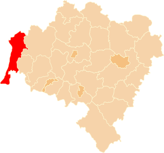
Zgorzelec is a town in southwestern Poland with 30,374 inhabitants (2019). It lies in Lower Silesian Voivodeship. It is the seat of Zgorzelec County and of Gmina Zgorzelec. Zgorzelec is located on the Lusatian Neisse river, on the Polish-German border adjoining the German town of Görlitz, of which it constituted the eastern part up to 1945.
Bolesławiec County is a unit of territorial administration and local government (powiat) in Lower Silesian Voivodeship, southwestern Poland. It came into being on January 1, 1999, as a result of the Polish local government reforms passed in 1998. Its administrative seat is the town of Bolesławiec, famed for its pottery, and its only other town is Nowogrodziec. The county covers an area of 1,303.3 square kilometres (503.2 sq mi).

Lubań County is a unit of territorial administration and local government (powiat) in Lower Silesian Voivodeship, south-western Poland. It came into being on January 1, 1999, as a result of the Polish local government reforms passed in 1998. The county covers an area of 428.2 square kilometres (165.3 sq mi). Its administrative seat and largest town is Lubań. The county also contains the towns of Olszyna, Leśna and Świeradów-Zdrój.
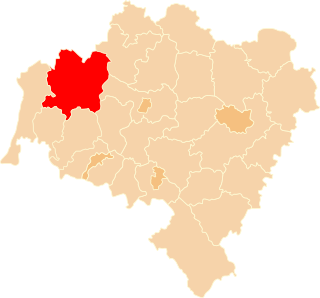
Zgorzelec County is a unit of territorial administration and local government (powiat) in Lower Silesian Voivodeship, Poland. It came into being on January 1, 1999, as a result of the Polish local government reforms passed in 1998. It is situated in the extreme south-west of Poland, bordering both Germany and the Czech Republic. The county covers an area of 838.1 square kilometres (323.6 sq mi). Its administrative seat is Zgorzelec, on the German border; the other towns in the county are Bogatynia, Pieńsk, Zawidów and Węgliniec.

Żary County is a unit of territorial administration and local government (powiat) in Lubusz Voivodeship, western Poland, on the German border. It came into being on January 1, 1999, as a result of the Polish local government reforms passed in 1998. Its administrative seat and largest town is Żary, which lies 43 km (27 mi) south-west of Zielona Góra and 123 km (76 mi) south of Gorzów Wielkopolski. The county contains three other towns: Lubsko, lying 21 km (13 mi) north-west of Żary, Jasień, lying 16 km (10 mi) north-west of Żary, and Łęknica, 30 km (19 mi) west of Żary.

Żagań County is a unit of territorial administration and local government (powiat) in Lubusz Voivodeship, western Poland. It came into being on January 1, 1999, as a result of the Polish local government reforms passed in 1998. Its administrative seat and largest town is Żagań, which lies 39 km (24 mi) south of Zielona Góra and 124 km (77 mi) south of Gorzów Wielkopolski. The county contains four other towns: Szprotawa, lying 14 km (9 mi) south-east of Żagań, Iłowa, lying 15 km (9 mi) south-west of Żagań, Małomice, lying 12 km (7 mi) south-east of Żagań, and Gozdnica, 25 km (16 mi) south-west of Żagań.
Gmina Siekierczyn is a rural gmina in Lubań County, Lower Silesian Voivodeship, in south-western Poland. Its seat is the village of Siekierczyn, which lies approximately 9 kilometres (6 mi) west of Lubań, and 130 kilometres (81 mi) west of the regional capital Wrocław.

Zawidów is a town in Zgorzelec County, Lower Silesian Voivodeship, in south-western Poland, at the Czech border.

Gryfów Śląski, simplified to Gryfów, is a historic town in Lwówek Śląski County, Lower Silesian Voivodeship, in south-western Poland. It is the seat of the administrative district (gmina) called Gmina Gryfów Śląski. As of 2019, the town has a population of 6,636. The town is located between Zgorzelec and Jelenia Góra, on the Kwisa river. It lies approximately 16 kilometres (10 mi) south-west of Lwówek Śląski, and 114 kilometres (71 mi) west of the regional capital Wrocław.

Pieńsk is a town in Zgorzelec County, Lower Silesian Voivodeship, in south-western Poland. It is the seat of the administrative district (gmina) called Gmina Pieńsk, and stands on the east bank of the Lusatian Neisse river, which forms the border between Poland and Germany.

Bogatynia is a town in Zgorzelec County, Lower Silesian Voivodeship, in south-western Poland.

Węgliniec is a town in Zgorzelec County, Lower Silesian Voivodeship, in south-western Poland, close to the border with Germany. It is the seat of the administrative district (gmina) called Gmina Węgliniec.
Gmina Stronie Śląskie is an urban-rural gmina in Kłodzko County, Lower Silesian Voivodeship, in south-western Poland, on the Czech border. Its seat is the town of Stronie Śląskie, which lies approximately 23 kilometres (14 mi) south-east of Kłodzko, and 93 kilometres (58 mi) south of the regional capital Wrocław.
Gmina Szczytna is an urban-rural gmina in Kłodzko County, Lower Silesian Voivodeship, in south-western Poland. Its seat is the town of Szczytna, which lies approximately 16 kilometres (10 mi) west of Kłodzko, and 90 kilometres (56 mi) south-west of the regional capital Wrocław.
Gmina Leśna is an urban-rural gmina in Lubań County, Lower Silesian Voivodeship, in south-western Poland. Its seat is the town of Leśna, which lies approximately 11 kilometres (7 mi) south of Lubań, and 125 kilometres (78 mi) west of the regional capital Wrocław.
Gmina Lubań is a rural gmina in Lubań County, Lower Silesian Voivodeship, in south-western Poland. Its seat is the town of Lubań, although the town is not part of the territory of the gmina.
Gmina Bogatynia is an urban-rural gmina in Zgorzelec County, Lower Silesian Voivodeship, in south-western Poland, bordering both the Czech Republic and Germany. Its seat is the town of Bogatynia, which lies approximately 27 kilometres (17 mi) south of Zgorzelec, and 147 kilometres (91 mi) west of the regional capital Wrocław.
Gmina Pieńsk is an urban-rural gmina in Zgorzelec County, Lower Silesian Voivodeship, in south-western Poland, on the German border. Its seat is the town of Pieńsk, which lies approximately 11 kilometres (7 mi) north of Zgorzelec, and 140 kilometres (87 mi) west of the regional capital Wrocław.

Gmina Sulików is a rural gmina in Zgorzelec County, Lower Silesian Voivodeship, in south-western Poland, on the Czech border. Its seat is the village of Sulików, which lies approximately 10 kilometres (6 mi) south-east of Zgorzelec, and 138 kilometres (86 mi) west of the regional capital Wrocław.
Gmina Węgliniec is an urban-rural gmina in Zgorzelec County, Lower Silesian Voivodeship, in south-western Poland. Its seat is the town of Węgliniec, which lies approximately 22 kilometres (14 mi) north-east of Zgorzelec, and 128 kilometres (80 mi) west of the regional capital Wrocław.


