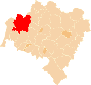
Bolesławiec County is a unit of territorial administration and local government (powiat) in Lower Silesian Voivodeship, southwestern Poland. It came into being on January 1, 1999, as a result of the Polish local government reforms passed in 1998. Its administrative seat is the town of Bolesławiec, famed for its pottery, and its only other town is Nowogrodziec. The county covers an area of 1,303.3 square kilometres (503.2 sq mi).

Legnica County is a unit of territorial administration and local government (powiat) in Lower Silesian Voivodeship, south-western Poland. It came into being on January 1, 1999, as a result of the Polish local government reforms passed in 1998. The county covers an area of 744.6 square kilometres (287.5 sq mi). Its administrative seat is the city of Legnica, although this city is not part of the county. The only towns in Legnica County are Chojnów and Prochowice.

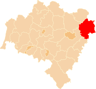
Kłodzko County is a unit of territorial administration and local government (powiat) in Lower Silesian Voivodeship, south-western Poland. It came into being on 1 January 1999 as a result of the Polish local government reforms passed in 1998.

Kamienna Góra County is a unit of territorial administration and local government (powiat) in Lower Silesian Voivodeship, south-western Poland. It came into being on January 1, 1999, as a result of the Polish local government reforms passed in 1998. The county covers an area of 396.1 square kilometres (152.9 sq mi). Its administrative seat is the town of Kamienna Góra; the only other town in the county is Lubawka.

Karkonosze County is a unit of territorial administration and local government (powiat) in Lower Silesian Voivodeship, south-western Poland. It came into being on January 1, 1999, as a result of the Polish local government reforms passed in 1998.

Lubań County is a unit of territorial administration and local government (powiat) in Lower Silesian Voivodeship, south-western Poland. It came into being on January 1, 1999, as a result of the Polish local government reforms passed in 1998. The county covers an area of 428.2 square kilometres (165.3 sq mi). Its administrative seat and largest town is Lubań. The county also contains the towns of Olszyna, Leśna and Świeradów-Zdrój.

Lubin County is a unit of territorial administration and local government (powiat) in Lower Silesian Voivodeship, south-western Poland. It came into being on January 1, 1999, as a result of the Polish local government reforms passed in 1998. The county covers an area of 712 square kilometres (274.9 sq mi). Its administrative seat and largest town is Lubin, and its only other town is Ścinawa.
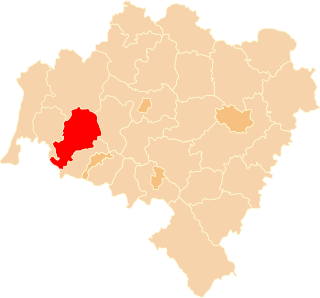
Lwówek County is a unit of territorial administration and local government (powiat) in Lower Silesian Voivodeship, south-western Poland. It came into being on January 1, 1999, as a result of the Polish local government reforms passed in 1998. The county covers an area of 709.9 square kilometres (274.1 sq mi). Its administrative seat is the town of Lwówek Śląski, and it also contains the towns of Gryfów Śląski, Mirsk, Wleń and Lubomierz.
Oleśnica County is a unit of territorial administration and local government (powiat) in Lower Silesian Voivodeship, south-western Poland. It was created on January 1, 1999, as a result of the Polish local government reforms passed in 1998. The county covers an area of 1,049.7 square kilometres (405.3 sq mi). Its administrative seat is the town of Oleśnica, and it also contains the towns of Syców, Twardogóra, Bierutów and Międzybórz.
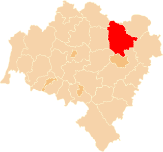
Trzebnica County is a unit of territorial administration and local government (powiat) in Lower Silesian Voivodeship, south-western Poland. It came into being on January 1, 1999, as a result of the Polish local government reforms passed in 1998. The county covers an area of 1,025.5 square kilometres (395.9 sq mi). Its administrative seat is Trzebnica, and it also contains the towns of Oborniki Śląskie, Żmigród and Prusice.

Ząbkowice County is a unit of territorial administration and local government (powiat) in Lower Silesian Voivodeship, south-western Poland. It came into being on January 1, 1999, as a result of the Polish local government reforms passed in 1998. The county covers an area of 801.75 square kilometres (309.6 sq mi). Its administrative seat is Ząbkowice Śląskie, and it also contains the towns of Ziębice, Złoty Stok and Bardo.

Wrocław County is a unit of territorial administration and local government (powiat) in Lower Silesian Voivodeship, south-western Poland. It came into being on January 1, 1999, as a result of the Polish local government reforms passed in 1998. The county covers an area of 1,116 square kilometres (431 sq mi). Its administrative seat is the city of Wrocław, although this city is not part of the county. Wrocław County consists of areas to the east and south of Wrocław, and contains three towns: Sobótka, Kąty Wrocławskie and Siechnice.

Wałbrzych County is a unit of territorial administration and local government (powiat) in Lower Silesian Voivodeship, south-western Poland. It was created on January 1, 1999, as a result of the Polish local government reforms passed in 1998. The county covers an area of 514.2 square kilometres (198.5 sq mi). Its administrative seat is the city of Wałbrzych, which is located outside of the county, and it also contains the towns of Boguszów-Gorce, Głuszyca, Szczawno-Zdrój, Jedlina-Zdrój and Mieroszów.

Żary County is a unit of territorial administration and local government (powiat) in Lubusz Voivodeship, western Poland, on the German border. It came into being on January 1, 1999, as a result of the Polish local government reforms passed in 1998. Its administrative seat and largest town is Żary, which lies 43 km (27 mi) south-west of Zielona Góra and 123 km (76 mi) south of Gorzów Wielkopolski. The county contains three other towns: Lubsko, lying 21 km (13 mi) north-west of Żary, Jasień, lying 16 km (10 mi) north-west of Żary, and Łęknica, 30 km (19 mi) west of Żary.

Żagań County is a unit of territorial administration and local government (powiat) in Lubusz Voivodeship, western Poland. It came into being on January 1, 1999, as a result of the Polish local government reforms passed in 1998. Its administrative seat and largest town is Żagań, which lies 39 km (24 mi) south of Zielona Góra and 124 km (77 mi) south of Gorzów Wielkopolski. The county contains four other towns: Szprotawa, lying 14 km (9 mi) south-east of Żagań, Iłowa, lying 15 km (9 mi) south-west of Żagań, Małomice, lying 12 km (7 mi) south-east of Żagań, and Gozdnica, 25 km (16 mi) south-west of Żagań.

Kościerzyna County is a unit of territorial administration and local government (powiat) in Pomeranian Voivodeship, northern Poland. It came into being on 1 January 1999 as a result of the Polish local government reforms passed in 1998. Its administrative seat and only town is Kościerzyna, which lies 51 kilometres (32 mi) south-west of the regional capital Gdańsk. Its borders equal approximately the borders of the old Marquessate of Berent in the German Empire.

Nysa County is a unit of territorial administration and local government (powiat) in Opole Voivodeship, south-western Poland, on the Czech border. It came into being on January 1, 1999, as a result of the Polish local government reforms passed in 1998. Its administrative seat and largest town is Nysa, which lies 48 kilometres (30 mi) south-west of the regional capital Opole. The county contains four other towns: Głuchołazy, 18 km (11 mi) south of Nysa, Paczków, 24 km (15 mi) west of Nysa, Otmuchów, 12 km (7 mi) west of Nysa, and Korfantów, 20 km (12 mi) east of Nysa.

Prudnik County is a unit of territorial administration and local government (powiat) in Opole Voivodeship, south-western Poland, on the Czech border. It came into being on January 1, 1999, as a result of the Polish local government reforms passed in 1998. Its administrative seat and largest town is Prudnik, which lies 46 kilometres (29 mi) south-west of the regional capital Opole. The county also contains the towns of Głogówek, lying 21 km (13 mi) east of Prudnik, and Biała, 11 km (7 mi) north-east of Prudnik.

Racibórz County is a unit of territorial administration and local government (powiat) in Silesian Voivodeship, southern Poland, on the Czech border. It came into being on January 1, 1999, as a result of the Polish local government reforms passed in 1998. Its administrative seat and largest town is Racibórz, which lies 58 kilometres (36 mi) west of the regional capital Katowice. The county also contains the towns of Kuźnia Raciborska, lying 16 km (10 mi) north of Racibórz, and Krzanowice, 11 km (7 mi) south-west of Racibórz.
Gmina Bogatynia is an urban-rural gmina in Zgorzelec County, Lower Silesian Voivodeship, in south-western Poland, bordering both the Czech Republic and Germany. Its seat is the town of Bogatynia, which lies approximately 27 kilometres (17 mi) south of Zgorzelec, and 147 kilometres (91 mi) west of the regional capital Wrocław.


