
Góra County is a unit of territorial administration and local government (powiat) in Lower Silesian Voivodeship, south-western Poland. It came into being on January 1, 1999, as a result of the Polish local government reforms passed in 1998. The county covers an area of 738.11 square kilometres (285.0 sq mi). Its administrative seat is the town of Góra; the only other town in the county is Wąsosz.

Legnica County is a unit of territorial administration and local government (powiat) in Lower Silesian Voivodeship, south-western Poland. It came into being on January 1, 1999, as a result of the Polish local government reforms passed in 1998. The county covers an area of 744.6 square kilometres (287.5 sq mi). Its administrative seat is the city of Legnica, although this city is not part of the county. The only towns in Legnica County are Chojnów and Prochowice.

Kamienna Góra County is a unit of territorial administration and local government (powiat) in Lower Silesian Voivodeship, south-western Poland. It came into being on January 1, 1999, as a result of the Polish local government reforms passed in 1998. The county covers an area of 396.1 square kilometres (152.9 sq mi). Its administrative seat is the town of Kamienna Góra; the only other town in the county is Lubawka.

Karkonosze County is a unit of territorial administration and local government (powiat) in Lower Silesian Voivodeship, south-western Poland. It came into being on January 1, 1999, as a result of the Polish local government reforms passed in 1998.

Lubin County is a unit of territorial administration and local government (powiat) in Lower Silesian Voivodeship, south-western Poland. It came into being on January 1, 1999, as a result of the Polish local government reforms passed in 1998. The county covers an area of 712 square kilometres (274.9 sq mi). Its administrative seat and largest town is Lubin, and its only other town is Ścinawa.

Świdnica County is a unit of territorial administration and local government (powiat) in Lower Silesian Voivodeship, south-western Poland. It came into being on January 1, 1999, as a result of the Polish local government reforms passed in 1998. The county covers an area of 742.9 square kilometres (286.8 sq mi). Its administrative seat is Świdnica, and it also contains the towns of Świebodzice, Strzegom, Jaworzyna Śląska and Żarów.

Środa County is a unit of territorial administration and local government (powiat) in Lower Silesian Voivodeship, south-western Poland. It came into being on January 1, 1999, as a result of the Polish local government reforms passed in 1998. The county covers an area of 703.7 square kilometres (271.7 sq mi). Its administrative seat and only town is Środa Śląska.

Polkowice County is a unit of territorial administration and local government (powiat) in Lower Silesian Voivodeship, south-western Poland. It came into being on January 1, 1999, as a result of the Polish local government reforms passed in 1998. The county covers an area of 779.9 square kilometres (301.1 sq mi). Its administrative seat is the town of Polkowice, and it also contains the towns of Chocianów and Przemków.
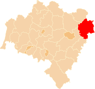
Oleśnica County is a unit of territorial administration and local government (powiat) in Lower Silesian Voivodeship, south-western Poland. It was created on January 1, 1999, as a result of the Polish local government reforms passed in 1998. The county covers an area of 1,049.7 square kilometres (405.3 sq mi). Its administrative seat is the town of Oleśnica, and it also contains the towns of Syców, Twardogóra, Bierutów and Międzybórz.
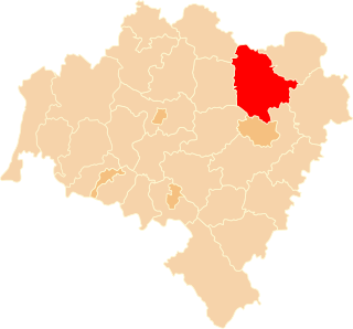
Trzebnica County is a unit of territorial administration and local government (powiat) in Lower Silesian Voivodeship, south-western Poland. It came into being on January 1, 1999, as a result of the Polish local government reforms passed in 1998. The county covers an area of 1,025.5 square kilometres (395.9 sq mi). Its administrative seat is Trzebnica, and it also contains the towns of Oborniki Śląskie, Żmigród and Prusice.

Złotoryja County is a unit of territorial administration and local government (powiat) in Lower Silesian Voivodeship, south-western Poland. It came into being on January 1, 1999, as a result of the Polish local government reforms passed in 1998. The county covers an area of 575.45 square kilometres (222.2 sq mi). Its administrative seat is Złotoryja, and it also contains the towns of Wojcieszów and Świerzawa.

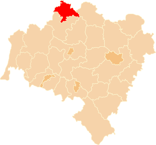
Wołów County is a unit of territorial administration and local government (powiat) in Lower Silesian Voivodeship, south-western Poland. It came into being on January 1, 1999, as a result of the Polish local government reforms passed in 1998. The county covers an area of 675 square kilometres (261 sq mi). Its administrative seat is the town of Wołów, although the county also contains the slightly larger town of Brzeg Dolny.

Wałbrzych County is a unit of territorial administration and local government (powiat) in Lower Silesian Voivodeship, south-western Poland. It was created on January 1, 1999, as a result of the Polish local government reforms passed in 1998. The county covers an area of 514.2 square kilometres (198.5 sq mi). Its administrative seat is the city of Wałbrzych, which is located outside of the county, and it also contains the towns of Boguszów-Gorce, Głuszyca, Szczawno-Zdrój, Jedlina-Zdrój and Mieroszów.

Żary County is a unit of territorial administration and local government (powiat) in Lubusz Voivodeship, western Poland, on the German border. It came into being on January 1, 1999, as a result of the Polish local government reforms passed in 1998. Its administrative seat and largest town is Żary, which lies 43 km (27 mi) south-west of Zielona Góra and 123 km (76 mi) south of Gorzów Wielkopolski. The county contains three other towns: Lubsko, lying 21 km (13 mi) north-west of Żary, Jasień, lying 16 km (10 mi) north-west of Żary, and Łęknica, 30 km (19 mi) west of Żary.

Zielona Góra County is a unit of territorial administration and local government (powiat) in Lubusz Voivodeship, western Poland. It came into being on January 1, 1999, as a result of the Polish local government reforms passed in 1998. Its administrative seat is the city of Zielona Góra, although the city is not part of the county. The county contains five towns: Sulechów, which lies 23 km (14 mi) north-east of Zielona Góra, Nowogród Bobrzański, which lies 25 km (16 mi) south-west of Zielona Góra, Babimost, which lies 40 km (25 mi) north-east of Zielona Góra, Czerwieńsk, which lies 11 km (7 mi) north-west of Zielona Góra, and Kargowa, 40 km (25 mi) north-east of Zielona Góra.

Krosno County is a unit of territorial administration and local government (powiat) in Lubusz Voivodeship, western Poland, on the German border. It came into being on January 1, 1999, as a result of the Polish local government reforms passed in 1998. Its administrative seat is the town of Krosno Odrzańskie, which lies 30 km (19 mi) west of Zielona Góra and 79 km (49 mi) south of Gorzów Wielkopolski. The only other town is Gubin which is the biggest town in the county. It is situated on the German border 28 km (17 mi) west of Krosno Odrzańskie.

Żagań County is a unit of territorial administration and local government (powiat) in Lubusz Voivodeship, western Poland. It came into being on January 1, 1999, as a result of the Polish local government reforms passed in 1998. Its administrative seat and largest town is Żagań, which lies 39 km (24 mi) south of Zielona Góra and 124 km (77 mi) south of Gorzów Wielkopolski. The county contains four other towns: Szprotawa, lying 14 km (9 mi) south-east of Żagań, Iłowa, lying 15 km (9 mi) south-west of Żagań, Małomice, lying 12 km (7 mi) south-east of Żagań, and Gozdnica, 25 km (16 mi) south-west of Żagań.
Nowa Sól County is a unit of territorial administration and local government (powiat) in Lubusz Voivodeship, western Poland. It came into being on January 1, 1999, as a result of the Polish local government reforms passed in 1998. Its administrative seat and largest town is Nowa Sól, which lies 22 km (14 mi) south-east of Zielona Góra and 109 km (68 mi) south of Gorzów Wielkopolski. The county contains three other towns: Kożuchów, lying 10 km (6 mi) south-west of Nowa Sól, Bytom Odrzański, lying 11 km (7 mi) south-east of Nowa Sól, and Nowe Miasteczko, 13 km (8 mi) south of Nowa Sól.
Głogów County is a unit of territorial administration and local government (powiat) in Lower Silesian Voivodeship, south-western Poland. It came into being on January 1, 1999, as a result of the Polish local government reforms passed in 1998. The county covers an area of 443.06 square kilometres (171.1 sq mi). Its administrative seat and only town is Głogów.
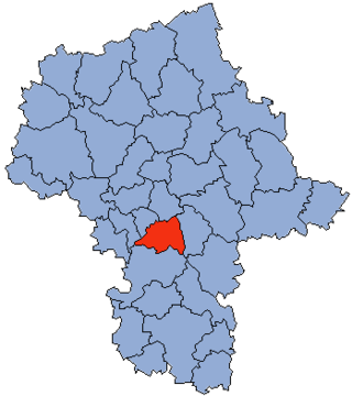
Piaseczno County is a unit of territorial administration and local government (powiat) in Masovian Voivodeship, east-central Poland. It came into being on January 1, 1999, as a result of the Polish local government reforms passed in 1998. Its administrative seat and largest town is Piaseczno, which lies 17 kilometres (11 mi) south of Warsaw. The county contains three other towns: Konstancin-Jeziorna, 8 km (5 mi) east of Piaseczno, Góra Kalwaria, 18 km (11 mi) south-east of Piaseczno, and Tarczyn, 16 km (10 mi) south-west of Piaseczno.


