The prehistory of the County of Norfolk, England is broken into specific time periods, these being Palaeolithic, Mesolithic and Neolithic.

Aadloun, Adloun or Adlun is a coastal municipality in South Lebanon, 17 kilometres (11 mi) south of Sidon famous for its cultivation of watermelons. It is also the site of a Phoenician necropolis and prehistoric caves where four archaeological sites have been discovered and dated to the Stone Age. The evidence of human occupation of Abri Zumoffen has been dated as far back as 71,000 BCE with occupation of Bezez Cave dating back even further into the earlier Middle Paleolithic.

The Vela Spila cave is situated above the town of Vela Luka on the island of Korčula, in Croatia on Pinski Rat hill at an elevation of approximately 130 m (430 ft). The cave consists of an elliptically shaped cavern that measures 40 m (130 ft) in length, 17 m (56 ft) in height, and is approximately 40 m (130 ft) wide. There are, similar to the Brillenhöhle in Germany, two openings in the roof of the cave which were caused by collapse at an as yet undetermined time.
Darra-e Kūr or Bābā Darwīsh, is an archaeological site in Badakhshan province in Afghanistan. It is situated just northeast of Kalafgān near the village of Chinār-i Gunjus Khān 63 km (39.1 mi) east of Taloqan, on the road to Faizabad. The cave is situated atop the side of the valley near the hamlet of Bābā Darwīsh.

Vanguard Cave is a natural sea cave in the British Overseas Territory of Gibraltar which is part of the Gorham's Cave complex. This complex of four caves has been nominated as a UNESCO World Heritage Site status in 2016. The cave complex is one of the last known habitations of the Neanderthals, with a period of inhabitation from 55,000 to 28,000 years ago. It is located on the southeast face of the Rock of Gibraltar.
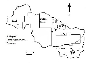
Fontbrégoua Cave is an archaeological site located in Provence, Southeastern France. It was used by humans in the fifth and fourth millennia BCE, in what is now known as the Early and Middle Neolithic. A temporary residential site, it was used by Neolithic agriculturalists as a storage area for their herds of goats and sheep, and also contained a number of bone depositions, containing the remains of domestic species, wild animals, and humans. The inclusion of the latter of these deposits led the archaeological team studying the site to propose that cannibalism had taken place at Fontbrégoua, although other archaeologists have instead suggested that they represent evidence of secondary burial.

Ibex Cave is a limestone cave on the Rock of Gibraltar which has yielded stone artifacts of Mousterian tradition. It was discovered in 1975. It is so named as an ibex skull was found within the cave which would have been hunted by the Neanderthals of Gibraltar thousands of years ago. Ibex Cave was named and excavated by the Gibraltar Museum in 1994. Its first formal description was in 1999. It is protected by the Heritage and Antiquities Act 2018 of the Government of Gibraltar.

Martin's Cave is a cave in the British Overseas Territory of Gibraltar. It opens on the eastern cliffs of the Rock of Gibraltar, below its summit at O'Hara's Battery. It is an ancient sea cave, though it is now located over 700 feet (210 m) above the shore of the Mediterranean Sea. It is only accessible because Martin's Path was constructed.
Bray's Cave is a limestone cave in the British Overseas Territory of Gibraltar. The cave has yielded several significant human remains and artifacts from the Neolithic and Bronze Ages. Three almost complete skulls were discovered, along with other cranial fragments from multiple individuals. This suggests that people repeatedly returned to the site to reuse it as a burial ground.

Cave S or Sewell's Cave is a limestone cave in the British Overseas Territory of Gibraltar. It is located on the eastern side of the Rock of Gibraltar, near Holy Boy's Cave. Prehistoric human remains were found in the cave in 1910, and the cave is listed by the Government of Gibraltar as a Palaeolithic site.

Holy Boy's Cave is a cave in the British Overseas Territory of Gibraltar. It is one of the largest of the many caves in Gibraltar and it is on the eastern side of the Rock, near Cave S. It is believed to be archaeologically important and is listed in the Heritage and Antiquities Act 2018.
Judge's Cave is a cave in the British Overseas Territory of Gibraltar. Human remains dated to the late prehistoric period have been unearthed in the cave. This Neolithic Shelter is protected by the law of Gibraltar.

Pete's Paradise Cave is a cave in the British Overseas Territory of Gibraltar. Explored in the 1960s and 1970s by a team led by George Palao, four skeletons have been unearthed in the cave, two of which were female skeletons with crushed skulls.
Devil's Tower Cave is a cave in the British Overseas Territory of Gibraltar. Archaeologist Dorothy Garrod found a Neanderthal skull in the cave which, together with other evidence found in this cave, shows it was used as a rock shelter by the Neanderthals of Gibraltar.
Part of series of articles upon Archaeology of Kosovo

The Burzahom archaeological site is located in the Srinagar district of the Kashmir Valley of Jammu and Kashmir, India. Evidences of wheat were found. Archaeological excavations have revealed four phases of cultural significance between 3000 BCE and 1000 BCE. Periods I and II represent the Neolithic era; Period III the Megalithic era ; and Period IV relates to the early Historical Period. The findings, recorded in stratified cultural deposits representing prehistoric human activity in Kashmir, are based on detailed investigations that cover all aspects of the physical evidence of the site, including the ancient flora and fauna.
This page is a glossary of archaeology, the study of the human past from material remains.
The Romito cave is a natural limestone cave in the Lao Valley of Pollino National Park, near the town of Papasidero in Calabria, Italy. Stratigraphic record of the first excavation confirmed prolonged paleo-human occupation during the Upper Paleolithic from 17,000 years ago and the Neolithic from 6,400 years ago. A single, but exquisite piece of Upper Paleolithic parietal rock engraving was documented. Several burial sites of varying age were initially discovered. Irregularly recurring sessions have led to additional finds, which suggests future excavation work. Notable is the amount of accumulated data that has revealed deeper understanding of prehistoric daily life, the remarkable quality of the rock carvings and the burial named Romito 2, who exhibits features of pathological skeletal conditions (dwarfism).

The La Garma cave complex is a parietal art-bearing paleoanthropological cave system in Cantabria, Spain. It is located just north of the village of Omoño, part of the municipality of Ribamontán al Monte. The cave complex is noted for one of the best preserved floors from the Paleolithic containing more than 4,000 fossils and more than 500 graphical units. It is part of the Cave of Altamira and Paleolithic Cave Art of Northern Spain World Heritage Site.
The Bockstein Cave, German: Bocksteinhöhle is part of the Bockstein complex – a White Jurassic limestone rock massif. The 15 by 20 m rock shelter, among small peripheral caves is situated around 12 m (39 ft) above the Lone River valley bottom, north of the towns of Rammingen and Öllingen, Heidenheim district in the central Swabian Jura, southern Germany. Several small openings, that are the actual entrances to the site, lead to various cave sections. The large frontal opening is of modern origin, created during the first excavation works in the late 19th century.

