Goat Peak

Last updated
Goat Peak

Goat Peak lookout tower.jpg

Goat Peak lookout tower
Highest point
Elevation 7,001 ft (2,134 m) [1]
Coordinates 48°37′56″N120°24′14″W / 48.632163986°N 120.403987653°W / 48.632163986; -120.403987653 Coordinates: 48°37′56″N120°24′14″W / 48.632163986°N 120.403987653°W / 48.632163986; -120.403987653 [2]
Geography
Location Okanogan County, Washington, U.S.
Parent range North Cascades
Topo map USGS Big Snow Mountain

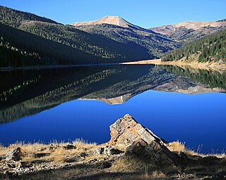
Goat Peak is a 7,001-foot (2,134 m) peak in the North Cascades of Washington, United States. The summit offers broad views of the Methow River valley, as well as many of the other prominent cascade peaks including glaciated Silver Star Mountain. A working US Forest Service fire lookout is located on the summit. The trailhead for Goat Peak is accessible from Forest Road 52, 1 mile (1.6 km) southeast of Mazama, starting at an elevation of 5,600 feet (1,700 m).

Mountain A large landform that rises fairly steeply above the surrounding land over a limited area

A mountain is a large landform that rises above the surrounding land in a limited area, usually in the form of a peak. A mountain is generally steeper than a hill. Mountains are formed through tectonic forces or volcanism. These forces can locally raise the surface of the earth. Mountains erode slowly through the action of rivers, weather conditions, and glaciers. A few mountains are isolated summits, but most occur in huge mountain ranges.

North Cascades mountains in the U.S. and Canada

The North Cascades are a section of the Cascade Range of western North America. They span the border between the Canadian province of British Columbia and the U.S. state of Washington and are officially named in the U.S. and Canada as the Cascade Mountains. The portion in Canada is known to Americans as the Canadian Cascades, a designation that also includes the mountains above the east bank of the Fraser Canyon as far north as the town of Lytton, at the confluence of the Thompson and Fraser Rivers.

United States Federal republic in North America

The United States of America (USA), commonly known as the United States or America, is a country composed of 50 states, a federal district, five major self-governing territories, and various possessions. At 3.8 million square miles, the United States is the world's third or fourth largest country by total area and is slightly smaller than the entire continent of Europe's 3.9 million square miles. With a population of over 327 million people, the U.S. is the third most populous country. The capital is Washington, D.C., and the largest city by population is New York City. Forty-eight states and the capital's federal district are contiguous in North America between Canada and Mexico. The State of Alaska is in the northwest corner of North America, bordered by Canada to the east and across the Bering Strait from Russia to the west. The State of Hawaii is an archipelago in the mid-Pacific Ocean. The U.S. territories are scattered about the Pacific Ocean and the Caribbean Sea, stretching across nine official time zones. The extremely diverse geography, climate, and wildlife of the United States make it one of the world's 17 megadiverse countries.

This Goat Peak is one of three summits with the same name in Washington state. [3]

Related Research Articles

Taum Sauk Mountain mountain

Taum Sauk Mountain in the Saint Francois Mountains is the highest natural point in the U.S. state of Missouri at 1,772 feet . The topography of Taum Sauk is that of an elongated ridge with a NNW-SSE orientation rather than a peak.

Mount Baker Wilderness

Mount Baker Wilderness is a 119,989-acre (48,558 ha) wilderness area within the Mount Baker-Snoqualmie National Forest in the western Cascade Range of northern Washington state. Its eastern border is shared with the boundary of the Stephen Mather Wilderness and North Cascades National Park for a distance of 40 miles. The wilderness extends from State Route 20 north to the Canada–US border. On the west, it is bounded by the foothills of the Puget Sound lowlands.

Maiden Peak (Oregon) mountain in United States of America

Maiden Peak is a steep-sided shield volcano in the Cascade Range of central Oregon. It is the highest point in the 43-mile (69 km) distance between Mount Bachelor and Diamond Peak. Ice Age glaciers carved a large cirque into the northeast flank of the mountain, exposing magma which hardened in the volcano's conduits to form the numerous rock pinnacles now found in the upper part of the cirque.

Union Peak mountain in United States of America

Union Peak is a heavily eroded shield volcano in the Cascade Range of central Oregon, located along the Cascade Crest less than 7 miles (11.3 km) southwest of the rim of Crater Lake. Ice Age glaciers eroded away most of the flanks of the volcano, leaving numerous deep cirques surrounding a central glacial horn. This is the same process that formed the summit horns of Three Fingered Jack, Mount Washington, Howlock Mountain, and Mount Thielsen from other shield volcanoes farther north in the Oregon Cascades.

Granite Mountain (King County, Washington) mountain in Washington, United States of America

Granite Mountain is a tall peak in the Cascade Range in King County, Washington 16 miles (26 km) east of North Bend. A fire lookout on the summit can be reached by trail. The fire lookout was first constructed in 1924 and was then rebuilt 31 years later. It is still maintained by volunteers June through September each year.

Mount Pilchuck State Park

Mount Pilchuck State Park is a public recreation area located seven miles (11 km) east of Granite Falls, Washington, on the western edges of the Cascade Mountains. The state park features 1,903 acres (770 ha) of alpine scenery, recreational activities, and Mount Pilchuck itself. The main point of interest is the 3-mile (4.8 km) trail to the peak and the old fire lookout located on the summit, 5,324 feet (1,623 m) above sea level.

Wyoming Peak mountain in the Wyoming Range in the U.S. state of Wyoming

Wyoming Peak is the tallest mountain in the Wyoming Range in the U.S. state of Wyoming. Situated in Bridger-Teton National Forest, a now collapsed fire lookout is located on the summit. Wyoming Peak is .75 miles (1.21 km) south-southeast of Coffin Peak, the second highest peak in the Wyoming Range.

Devils Head (summit) mountain in Colorado, United States of America

Devils Head is a mountain summit in the Rampart Range of the Rocky Mountains of Colorado. The 9,749-foot (2,971 m) peak is located in Pike National Forest, 14.2 miles (22.9 km) southwest by south of the community of Sedalia in Douglas County, Colorado, United States.

OLeary Peak

O'Leary Peak is an extinct Pleistocene lava dome volcano within the San Francisco volcanic field, north of Flagstaff, Arizona, and to the northwest of Sunset Crater National Monument. A fire lookout tower was built on a subsidiary eastern peak. It has and elevation of 8,919 feet (2,719 m).

Mount Ellinor mountain in United States of America

Mount Ellinor is a peak in the Olympic Mountains of Washington, United States. It is located in an area designated as the Mount Skokomish Wilderness. The mountain is a popular day hike in the summer months, being that the summit is reachable via a steep-but-brief 3.3-mile (5.3 km) trail which gains about 3,200 feet (980 m) in elevation from the lower of two trailheads. Mountain goats are frequently observable along this trail, but it is advisable to keep a safe distance from them. The trailhead is accessible from National Forest Road 24 north of Lake Cushman. This lower trailhead lies at an elevation of 2,600 feet (790 m). A Northwest Forest Pass or appropriate parking permit is required at the upper trailhead, which starts at 3,500 feet.

Lookout Mountain (Idaho) mountain in Custer County, Idaho, United States

Lookout Mountain at 9,954 feet (3,034 m) above sea level is a peak in the White Cloud Mountains of Idaho. The peak is located in Sawtooth National Recreation Area in Custer County 4.72 mi (7.60 km) from Blackmon Peak, its line parent. A maintained trail goes to the summit where an old U.S. Forest Service fire lookout is located. The lookout was built by the Civilian Conservation Corps and was recently refurbished.

Sourdough Mountain (Whatcom County, Washington) mountain in Whatcom County, Washington, United States of America

Sourdough Mountain is in North Cascades National Park in the U.S. state of Washington. The Sourdough Mountain Lookout, is a fire lookout that was built by the Civilian Conservation Corps in 1933 near the summit. The lookout was placed on the National Register of Historic Places in 1989.

Sex Peak is a summit in Sanders County, Montana, in the United States. It is located within the Kootenai National Forest. With an elevation of 5,751 feet (1,753 m), Sex Peak is the 2,052nd highest mountain in Montana.

Hager Mountain mountain in Oregon, United States of America

Hager Mountain is a volcanic peak in Oregon in the northwest corner of the Basin and Range Province in the United States. The mountain is located south of the small unincorporated community of Silver Lake in south-central Oregon, and it is in the Fremont–Winema National Forest. On the summit, there is a fire lookout operated during the summer and fall by the United States Forest Service. There are several hiking trails that lead to the lookout station.

Chinese Peak (Idaho)

Chinese Peak is a summit in Bannock County, Idaho, in the United States. This peak is the highest point in the portion of the Portneuf Range called the Pocatello Range. With an elevation of 6,791 feet (2,070 m), Chinese Peak is the 1069th highest summit in the state of Idaho. The peak is a fire lookout site and a road/bike trail leads to the top.

References

  1. "Goat Peak". ListsOfJohn.com. Retrieved November 14, 2012.
  2. "Goat Peak lookout tower". NGS data sheet. U.S. National Geodetic Survey.
  3. "Goat Peak, Washington". Geographic Names Information System, U.S. Geological Survey . Retrieved November 14, 2012.
Goat Peak, Cascades.jpg
360° panorama on a September afternoon near the summit of Goat Peak in the northern Cascades in Washington State. There are views of the Methow River Valley and the greater Cascade Range including glaciated Silver Star Mountain. Goat Peak Lookout is prominent on the right side. High ice clouds create sun dogs on either side of the sun.