
Buckner Mountain is a tall peak in the North Cascades of Washington state and in the Stephen Mather Wilderness of North Cascades National Park. At 9,114 feet (2,778 m) in elevation it is the highest in Skagit County and one of about ten of Washington's non-volcanic peaks above 9,000 feet high. It is ranked as the 14th highest peak in the state, and the third highest peak in North Cascades National Park.
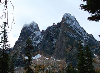
Liberty Bell Mountain is located in the North Cascades, State of Washington, United States, approximately one mile south of Washington Pass on the North Cascades Highway. Liberty Bell is the most northern spire of the Liberty Bell Group, a group of spires that also includes Concord Tower, Lexington Tower, North Early Winters Spire, and South Early Winters Spire.

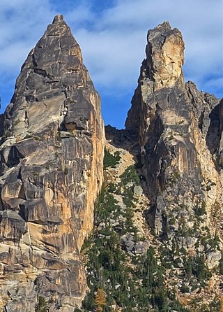
The Early Winters Spires are two rock formations in the Liberty Bell Group of the North Cascade Range, set between Liberty Bell Mountain and Blue Lake Peak in Washington state, United States. The two spires are virtually one granite massif, split by a deep cleft formed by jointing and erosion. The shapes of these spires are attributed to ice wedging, cleaving along master joints by soil acids, and perpetual weathering.

Big Kangaroo is an 8,280+ ft granitic mountain located in Okanogan County, Washington. The mountain is part of the Methow Mountains in the Cascade Range. Big Kangaroo is the high point of Kangaroo Ridge which is about two miles east and within view of Washington Pass. Its nearest higher peak is Snagtooth Ridge, 1.7 mi (2.7 km) to the northeast. Precipitation runoff from the peak drains into Early Winters Creek which is a tributary of the Methow River.

Mount Larrabee is a 7,865-foot (2,397-metre) Skagit Range mountain summit situated 1.4 mile south of the Canada–United States border, in the North Cascades of Washington state. It is located immediately southeast of American Border Peak within the Mount Baker Wilderness, which is part of the Mount Baker-Snoqualmie National Forest, and near North Cascades National Park. It is notable for its reddish coloring caused by oxidation of Iron in the rock. The rock consists of reddish interbedded and interfolded phyllites and greenstone. Originally known as Red Mountain, the name was changed in 1951 to honor Charles F. Larrabee (1895–1950), of the prominent Larrabee family of Bellingham, Washington. The name was officially adopted in 1951 by the U.S. Board on Geographic Names.

Hinkhouse Peak is a 7,560-foot-elevation (2,300-meter) mountain summit located on the shared border of Okanogan County and Chelan County in Washington state. It is part of the Okanogan Range which is a sub-range of the North Cascades Range. Hinkhouse Peak is situated on land administered by the Okanogan–Wenatchee National Forest. The nearest higher neighbor is Liberty Bell Mountain, 1.52 miles (2.45 km) to the south. Hinkhouse Peak is situated north of Washington Pass, at the east end of a high ridge which connects to Cutthroat Peak. A high ridge extending northeast connects it to Constitution Crags. Most precipitation runoff from the peak drains into Early Winters Creek which is a tributary of the Methow River, but the south slope drains into a tributary of the Chelan River. Topographic relief is significant as it rises nearly 3,200 feet above Early Winters Creek in approximately one mile.

Snagtooth Ridge is a jagged granitic ridge located in Okanogan County of Washington state. It is part of the Methow Mountains which is a sub-range of the North Cascades. Snagtooth Ridge is situated between Silver Star Mountain and Kangaroo Ridge on land administered by the Okanogan–Wenatchee National Forest.
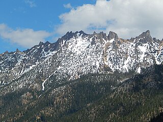
Vasiliki Ridge is a three-mile-long ridge located in Okanogan County of Washington state. It is part of the Methow Mountains which is a sub-range of the North Cascades. Vasiliki Ridge is situated north of Silver Star Mountain on land administered by the Okanogan–Wenatchee National Forest. The name Vasiliki was recommended by climber Fred Beckey who made the first ascent in 1952. Vasiliki Ridge can be seen from Washington Pass and from the North Cascades Highway.

Stiletto Peak is a 7,660 ft summit located in the Methow Mountains, a sub-range of the North Cascades in Washington state. It is situated in the Stephen Mather Wilderness on a ridge which also has Switchblade Peak and Jackknife Peak to its east. Stiletto Peak is also located on the boundary of North Cascades National Park, 2.24 miles (3.60 km) due north of Hock Mountain. Precipitation runoff on the north side of the mountain drains into Bridge Creek via Copper Creek, whereas the south side of the mountain drains into the East Fork Bridge Creek.

Blue Lake Peak is the unofficial name of a 7,800+ ft summit in the North Cascades Range in the U.S. state of Washington. It is located in the Okanogan–Wenatchee National Forest on the shared border of Okanogan County and Chelan County. It is situated south of Early Winters Spires, Liberty Bell Mountain, and Washington Pass. Blue Lake is set below its west slope, and Stiletto Peak is to its south. Blue Lake Peak can be seen from the North Cascades Highway at the Blue Lake Trailhead. Precipitation runoff from Blue Lake Peak drains into tributaries of the Chelan River and Methow River.

Constitution Crags is a 6,978-foot-elevation summit located in Okanogan County of Washington state. It is part of the Okanogan Range which is a sub-range of the North Cascades. Constitution Crags is situated west of Silver Star Mountain on land administered by the Okanogan–Wenatchee National Forest. The nearest higher neighbor is Hinkhouse Peak, 0.62 mile to the southwest. Washington Pass is located over a mile south of Constitution Crags, and the North Cascades Highway traverses below the east face of Constitution Crags. Like many North Cascade peaks, Constitution Crags is more notable for its large, steep rise above local terrain than for its absolute elevation. Precipitation runoff from the peak drains into Early Winters Creek which is a tributary of the Methow River.

Mount Chaval is a craggy 7,127-foot (2,172-metre) mountain summit located in Skagit County of Washington state. Situated within the Glacier Peak Wilderness, Mount Chaval is positioned west of the crest of the North Cascades Range, approximately 15 miles northeast of the town of Darrington. It has two subsidiary peaks, East Peak and Middle Peak, each 7040 ft. Its nearest higher neighbor is Snowking Mountain, 2.51 miles (4.04 km) to the northeast. Precipitation runoff from Mount Chaval drains into tributaries of the Skagit River.
Tricouni Peak is an 8,102-foot (2,469-metre) mountain summit located in Skagit County of Washington state. It is situated in North Cascades National Park, north of the North Klawatti Glacier and southeast of the Borealis Glacier. Its nearest higher peak is Primus Peak, 0.54 mi (0.87 km) to the west. Precipitation runoff from Tricouni drains into Thunder Creek. The peak is named for the tricouni which was used for traction on ice, and the approach to the peak involves traversing a glacier.

Dorado Needle is an 8,440+ ft mountain summit located in North Cascades National Park in Skagit County of Washington state. The peak lies 0.73 miles north of Eldorado Peak and 1.33 mi (2.14 km) southeast of Perdition Peak. It can be seen from the North Cascades Highway west of Marblemount at a road pullout along the Skagit River. The first ascent of the peak was made in July 1940 by Lloyd Anderson, Karl Boyer, and Tom Gorton via the Northwest Ridge. Precipitation runoff and glacier meltwater from the mountain drains into tributaries of the Skagit River.
Early Morning Spire is an 8,200-foot (2,500-metre) mountain summit located in North Cascades National Park, in Skagit County of Washington state. The peak lies 0.29 mi (0.47 km) west-northwest of Dorado Needle, 1.05 mi (1.69 km) north-northwest of Eldorado Peak and 1.08 mi (1.74 km) southeast of Perdition Peak. It can be seen from the North Cascades Highway, west of Marblemount at a road pullout alongside the Skagit River. The first ascent of the peak was made in 1971 by Richard Emerson and Tom Hornbein via the Southwest Face. They made a chilly bivouac near the summit, which is how the peak's name came to be. Precipitation runoff from the mountain drains into Marble Creek, a tributary of the Cascade River.

Castle Peak is a prominent 8,306-foot (2,532-metre) mountain summit located in the Hozameen Range of the North Cascades, on the shared border between Okanogan County and Whatcom County of Washington state. The mountain is situated 1 mile (1.6 km) south of the Canada–United States border, on the Cascade crest, in the Pasayten Wilderness, on land managed by the Okanogan–Wenatchee National Forest. The nearest higher peak is Jack Mountain, 14.8 miles (23.8 km) to the south-southwest. Castle Peak is the second highest summit of the Hozameen Range following Jack Mountain. Castle Peak is the fifth-most prominent mountain in the Pasaten Wilderness. Precipitation runoff from the mountain drains east into Castle Creek, a tributary of the Similkameen River, or west into tributaries of the Skagit River.

Wallaby Peak is a 7,995-foot (2,437-metre) mountain summit located on the boundary line of the Lake Chelan-Sawtooth Wilderness, in Okanogan County, Washington. The mountain is part of the Methow Mountains, which are a subset of the Cascade Range. Wallaby Peak is situated on Kangaroo Ridge which is approximately two miles east and within view of Washington Pass. The nearest higher peak is Big Kangaroo, 0.86 mi (1.38 km) to the north. Precipitation runoff from the peak drains into Early Winters Creek, Cedar Creek, and North Fork Twisp River, all of which are tributaries of the Methow River.

Half Moon is a 7,960+ ft summit located in Okanogan–Wenatchee National Forest, in Okanogan County, of Washington state. The mountain is part of the Methow Mountains, which are a subset of the Cascade Range. Half Moon is situated on Kangaroo Ridge which is approximately two miles east and within view of the North Cascades Highway at Washington Pass. Its nearest higher peak is Wallaby Peak, 0.23 mi (0.37 km) to the south. Precipitation runoff from the peak drains into Early Winters Creek, and Cedar Creek, both of which are tributaries of the Methow River.

White Goat Mountain is a 7,800+ ft mountain summit located in the Glacier Peak Wilderness of the North Cascades in Washington state. The mountain is situated in Chelan County, on land managed by Wenatchee National Forest. Its nearest higher neighbor is Tupshin Peak, 0.7 mi (1.1 km) to the northeast, and Devore Peak is 1.02 mi (1.64 km) to the south. Precipitation runoff from the peak drains to nearby Lake Chelan via Company and Devore Creeks. The first ascent was made September 10, 1940, by Everett and Ida Zacher Darr, Joe Leuthold, and Eldon Metzger. A herd of mountain goats beneath the peak was their inspiration for so naming this geographical feature.
Lexington Tower is a 7,560-foot-elevation (2,300-meter) granite pinnacle located in the North Cascades, approximately one mile south of Washington Pass along the North Cascades Highway. It is set within the Okanogan–Wenatchee National Forest, on the shared border of Okanogan County and Chelan County in the state of Washington. Lexington Tower is part of the iconic Liberty Bell Group, a group of spires which also includes Liberty Bell Mountain, Concord Tower, and the Early Winters Spires. Precipitation runoff from Lexington Tower drains west into State Creek and east into Early Winters Creek. Topographic relief is significant as the summit rises 2,500 feet above Early Winters Creek in approximately one-half mile.


