Gobabis is a town in eastern Namibia. It is the regional capital of the Omaheke Region, and the district capital of the Gobabis electoral constituency. Gobabis is situated 200 km (120 mi) down the B6 motorway from Windhoek to Botswana. The town is 113 km (70 mi) from the Buitepos border post with Botswana, and serves as an important link to South Africa on the tarred Trans-Kalahari Highway. Gobabis is in the heart of the cattle farming area. In fact Gobabis is so proud of its cattle farming that a statue of a large Brahman bull with the inscription "Cattle Country" greets visitors to the town. Gobabis also has its own local airport.

Keetmanshoop is a town in the ǁKaras Region of southern Namibia, lying on the Trans-Namib Railway from Windhoek to Upington in South Africa. It is named after Johann Keetman, a German industrialist and benefactor of the city.

Omaruru is a town in the Erongo Region of central Namibia. The town has 14,000 inhabitants and encompasses 352 square kilometres (136 sq mi) of land. It is situated near Mount Erongo, on the usually dry Omaruru River. It is located on the main paved road from Swakopmund to Otjiwarongo. The name in the Otjiherero language means 'bitter milk', as Herero cattle herds used to graze on the local bush that turned their milk bitter.

Keetmanshoop Urban is a constituency in the ǁKaras Region of Namibia. It comprises the city of Keetmanshoop, except the Krönlein suburb. It had a population of 19,447 in 2011, up from 15,777 in 2001. As of 2020 the constituency had 12,569 registered voters, up from 11,534 in 2019.

Khomasdal Constituency is a constituency in Windhoek in the Khomas Region of Namibia. As of December 2019 it had 25,550 registered voters. The constituency consists of parts of the suburbs Khomasdal, Katutura, and Otjomuise. It had a population of 43,921 in 2011, up from 27,950 in 2001.

Elections in Namibia determine who holds public political offices in the country. Namibia is a semi-presidential representative democratic republic. It runs direct elections every five years for the position of the president and seats in the National Assembly, and every six years for the Regional Councils and the distribution of seats in local authorities. The National Council is elected indirectly by the constituency councillors of Namibia's 14 regions.
Okahandja is a city of 45,159 inhabitants in Otjozondjupa Region, central Namibia, and the district capital of the Okahandja electoral constituency. It is known as the Garden Town of Namibia. It is located 70 km north of Windhoek on the B1 road. It was founded around 1800, by two local groups, the Herero and the Nama.

Henties Bay is a coastal town in the Erongo Region of western Namibia. It is located 72 kilometres (45 mi) north of Swakopmund and is a holiday and retirement settlement, with angling a popular activity. It also serves as a gateway to the seal colony of Cape Cross, which lies 46 kilometres (29 mi) to the north of the town. The town had 4,720 inhabitants in 2011, an increase from 3,285 in 2001. The mayor of Henties Bay is Lewies Vermaak.

Karasburg is a town with 4,000 inhabitants in the ǁKaras Region of southern Namibia and the district capital of the Karasburg electoral constituency. It lies at the heart of the southern Namibian sheep farming industry.

Omuthiyagwiipundi is the capital of Oshikoto Region in northern Namibia, situated approximately 10 kilometres (6.2 mi) from Etosha National Park. It has about 7,500 residents. Prior to Omuthiya, Tsumeb was the regional capital. The town has been proclaimed in October 2007 and the Omuthiya Town Council established in September 2008.

Aroab is a village with a population of approximately 5,000 in the ǁKaras Region of southern Namibia. It is situated about 170 kilometres (110 mi) south-east of Keetmanshoop on the edge of the Kalahari desert; the average annual rainfall is about 150–200 mm. Aroab is the district centre of the Keetmanshoop Rural electoral constituency.
Oniipa is a town in the Oshikoto Region of northern Namibia and the district capital of the Oniipa electoral constituency. It lies just outside Ondangwa.

Kalahari Constituency is an electoral constituency in the Omaheke Region of eastern central Namibia. It had 9,234 inhabitants in 2004 and 5,294 registered voters in 2020. The constituency covers the rural area east of Gobabis as well as Gobabis' Nossobville suburb. The constituency office has been inaugurated in 2009 and is located at the Ben-Hur settlement. Kalahari constituency forms part of the border between Namibia and Botswana.
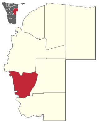
Gobabis Constituency is an electoral constituency in the Omaheke Region of Namibia. As of December 2019 it had 13,457 registered voters. The constituency covers the rural area southeast of Gobabis and the town itself, except its Nossobville suburb. Gobabis is also the administrative centre of the constituency.

Aranos is a town in the Hardap Region of central Namibia, situated in the Nossob River basin in the Kalahari Desert.

Otjinene is a village in the Omaheke Region of Namibia. It is the district capital of the Otjinene Constituency. Otjinene is connected via a 157 kilometres (98 mi) tarred road to the regional capital Gobabis, and via a 227 kilometres (141 mi) road which was tarred in 2017, to Grootfontein.

Witvlei is a village in the Okarukambe Constituency in the Omaheke Region of central-eastern Namibia. It is situated on the B6 150 kilometres (93 mi) from Windhoek on the way to Gobabis. It is known for producing high quality meat.

Walvis Bay Urban is a constituency in the Erongo Region of Namibia, comprising most of the city of Walvis Bay. It had a population of 35,828 in 2011, up from 27,941 in 2001. As of 2020 the constituency had 25,311 registered voters.

Leonardville is a village in eastern Namibia, situated on the Nossob River in the south-western corner of the Omaheke Region. It belongs to the Aminuis electoral constituency.